PAGASA: Helen exits PAR, heads for Japan

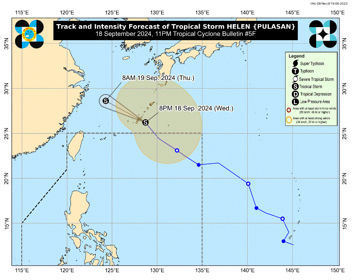
Tropical storm Helen has exited the Philippine Area of Responsibility (PAR) and is now moving at 40 kilometers per hour (km/h) towards Japan, PAGASA said in its 11 p.m. cyclone bulletin.
Helen was last seen at 915 northeast of extreme Northern Luzon, with maximum sustained winds of 85 km/h and gustiness of up to 105 km/h.
The effects of Helen and the Southwest Monsoon (Habagat), enhanced by recently exited typhoon Gener, will cause rainfall over the following areas within the next few days:
- Wednesday to Thursday evening: Zambales and Bataan (100 to 200 mm), Pangasinan, Occidental Mindoro, and Calamian Islands (50 to 100 mm)
- Thursday evening to Friday evening: Ilocos Region, Zambales, and Bataan (50 to 100 mm)
- Friday evening to Saturday evening: Batanes, Babuyan Islands, and Ilocos Norte (50 to 100 mm)
PAGASA warned that flooding and landslides are likely to occur over the following areas and advised concerned offices to remain vigilant.
Habagat and Helen will also bring strong to gale-force winds over the following areas:
- Wednesday and Thursday: Ilocos Region, Isabela, Aurora, Zambales, Bataan, Metro Manila, CALABARZON, MIMAROPA, Bicol Region, Western Visayas, Negros Island Region, and Zamboanga Peninsula
- Friday: Batanes, Babuyan Islands Ilocos Region, Abra, Benguet, Aurora, Zambales, Bataan, Cavite, Batangas, Quezon, Occidental Mindoro, Marinduque, Romblon, and Kalayaan Islands
- Saturday: Batanes, Babuyan Islands Ilocos Region, Abra, Benguet, and Zambales
A gale warning has been placed in effect over the western seaboard of Central Luzon, the seaboard of Occidental Mindoro, and the western seaboard of Palawan including Kalayaan Islands.
According to PAGASA, after making landfall in Kunigami, Okinawa, Japan at 10:20 pm Wednesday, Helen will continue its fast northwestward or west northwestward movement over East China until it makes landfall over mainland China Thursday afternoon or evening as a tropical storm.—LDF, GMA Integrated News


