

Helen now over north PH Sea, enhances Habagat as heavy rains hit Luzon
Tropical Storm Helen moved over the northern section of the Philippine Sea as it enhanced the Southwest Monsoon or Habagat, with intense rains over some areas in Luzon on Wednesday, state weather bureau PAGASA said.
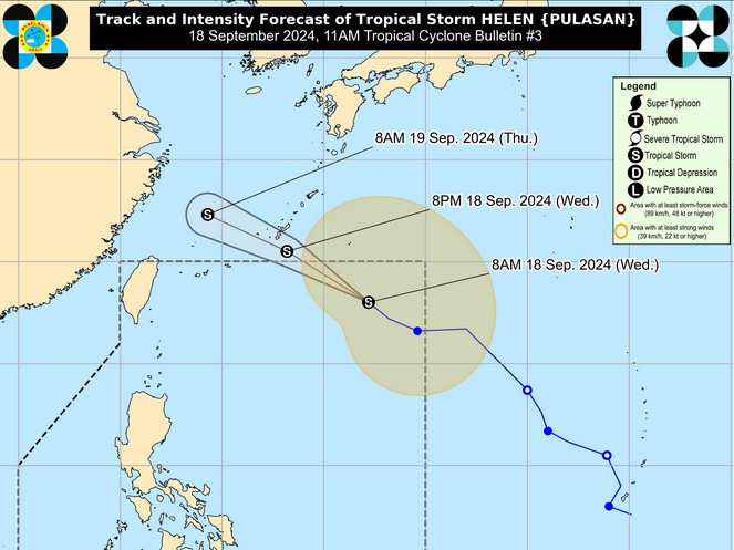
In its 11 a.m. bulletin, PAGASA said Helen was spotted 1,060 kms east northeast of extreme northern Luzon, packing maximum sustained winds of 85 kph and gustiness of up to 105 kph.
The tropical storm was moving northwestward at 25 kph.
Enhanced by tropical cyclones Helen and Gener, which is already outside the Philippine Area of Responsibility (PAR), Habagat will bring poor weather conditions in the following areas in the next 24 hours:
Heavy to intense rains
- Palawan
- Occidental Mindoro
- Zambales
- Bataan
Moderate to heavy rains
- Metro Manila
- Pangasinan
- Batangas
- Cavite
- the rest of MIMAROPA
PAGASA said "forecast rainfall are generally higher in elevated or mountainous areas."
"Under these conditions, flooding and rain-induced landslides are expected especially in areas that are highly or very highly susceptible to these hazards as identified in hazard maps and in localities that experienced considerable amounts of rainfall for the past several days," PAGASA warned.
Helen is expected to move northwestward for the entire forecast period and exit the PAR on Wednesday afternoon or evening, according to PAGASA.
"Throughout the forecast period, HELEN will remain far from the Philippine landmass and will not directly affect any part of the country," PAGASA said.
"HELEN is forecast to remain as a tropical storm and may gradually weaken over the East China Sea," it added. — VDV, GMA Integrated News
