

Gener now outside PAR but will continue to enhance Habagat with Helen
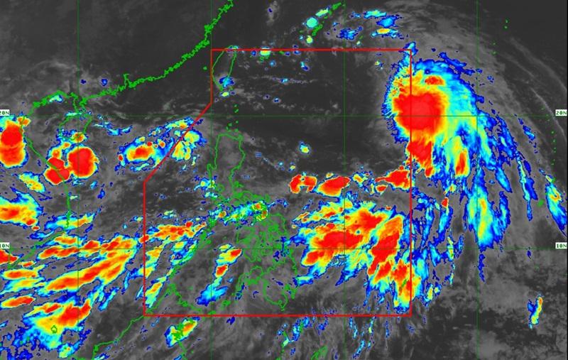
Tropical Storm Helen continues to move west northwestward over the Philippine Sea as Tropical Depression Gener exited the Philippine Area of Responsibility (PAR), PAGASA said in its latest bulletin on Wednesday morning.
As of 4 a.m., Helen was estimated at 1,150 kilometers east northeast of extreme Northern Luzon packing maximum sustained winds of 85 kilometers per hour near the center, gustiness of up to 105 kph, and central pressure of 992 hPa.
Helen is moving west northwestward at the speed of 25 kph with strong to gale-force winds extend outwards up to 650 km from the center.
The center of Gener, meanwhile, was estimated at 410 kilometers west of Bacnotan, La Union packing maximum sustained winds of 55 kph near the center, gustiness of up to 70 km/h, and central pressure of 996 hPa, and moving westward at 15 kph with strong winds extend outwards up to 360 km from the center.
No tropical cyclone wind signal is currently in effect.
Rainfall
Palawan, Occidental Mindoro, and Antique will experience rains due to the southwest monsoon with flashfloods or landslides possibly occurring due to heavy to intense rains.
The rest of MIMAROPA, the rest of Western Visayas, Batangas, Zambales, Bataan, and Pangasinan will have occasional rains due to the southwest monsoon with the possibility that flash floods or landslides will occur due to moderate to heavy rains.
Metro Manila, Zamboanga Peninsula, BARMM, Caraga, Northern Mindanao, Cordillera Administrative Region, Bicol Region, and the rest of Visayas, CALABARZON, Central Luzon, and Ilocos Region will have cloudy skies with scattered rains and thunderstorms due to the southwest monsoon with the possibility that flash floods or landslides will occur due to moderate to at times heavy rains.
The rest of the country will have partly cloudy to cloudy skies with isolated rain showers or thunderstorms due to the southwest monsoon with the possibility that flash floods or landslides will occur during severe thunderstorms.
Severe Winds
The Southwest Monsoon enhanced by Gener and Helen will also bring strong to gale-force gusts over the following areas (especially in coastal and upland areas exposed to winds): Zambales, Bataan, Pampanga, Bulacan, Metro Manila, CALABARZON, MIMAROPA, Bicol Region, Visayas, Zamboanga Peninsula, Northern Mindanao, Caraga, and Davao Region.
The western section of Southern Luzon and Visayas will experience strong wind speed moving southwestward while coastal waters will be rough.
The rest of Luzon and Visayas will experience moderate to strong wind speed moving in the southwest to south direction with moderate to rough coastal waters.
Mindanao residents will experience moderate to strong wind speed moving in the south to southwest direction with moderate to rough coastal waters.
24-Hour Sea Condition Outlook
A Gale Warning is in effect over several coastal waters in the western seaboard of Central Luzon, Southern Luzon, and Visayas, PAGASA also reported. Sea travel in these waters is risky for small seacrafts, including all types of motorbancas.
Track and Intensity Outlook
The weather bureau reported that Helen is forecast to move generally west northwestward for the entire forecast period and may exit the PAR region by Wednesday afternoon or evening.
"Throughout the forecast period, Helen will remain far from the Philippine landmass and will not directly affect any part of the country," PAGASA said, adding that Helen is forecast to remain as a tropical storm and may gradually weaken over the East China Sea. — BAP, GMA Integrated News
