

Signal No. 1 up in 18 areas in Luzon due to Gener
At least 18 areas in Luzon remain under storm signal No. 1 due to Tropical Depression Gener.
In its 11 a.m. bulletin, PAGASA said storm signal number 1 is hoisted over the following areas:
- Cagayan including Babuyan Islands
- Isabela
- Quirino
- Nueva Vizcaya
- Apayao
- Kalinga
- Abra
- Ifugao
- Mountain Province
- Benguet
- Ilocos Norte
- Ilocos Sur
- La Union
- Pangasinan
- Zambales
- Tarlac
- Nueva Ecija
- Pampanga
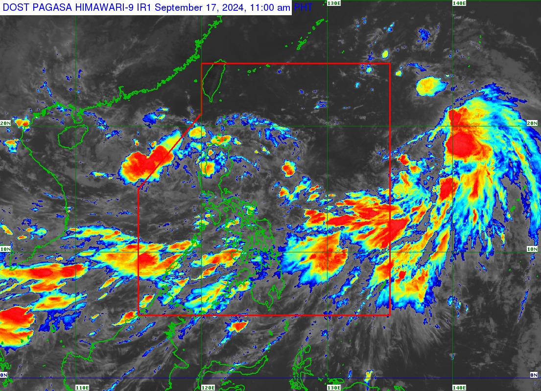
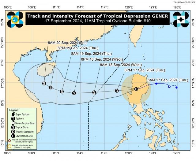
The center of the eye of the tropical cyclone was last seen in the vicinity of Kibungan, Benguet. It is moving westward at 15 km/h while 45 km/h near the center, gustiness of up to 55 km/h, and central pressure of 998 hPa.
Heavy rainfall
Meanwhile, an accumulated rainfall of 100-200 mililiters is expected over Cagayan, Apayao, Kalinga, Mountain Province, Ifugao, Ilocos Norte, and Abra from Tuesday to Wednesday, September 18 due to the effects of Gener and the Southwest monsoon, enhanced by Gener and Tropical Storm Pulasan.
At least 50-100 mm of rains are forecast over the rest of Cordillera Administrative Region (CAR), the rest of Cagayan Valley, the rest of Ilocos Region, Nueva Ecija, Bulacan, Quezon, Rizal, and Aurora province.
“Under these conditions, flooding and rain-induced landslides are possible especially in areas that are highly or very highly susceptible to these hazards as identified in official hazard maps and in localities that experienced considerable amounts of rainfall for the past several days,” said PAGASA.
Severe winds
Meanwhile, PAGASA warned of minimal to minor impacts from strong winds are possible within any of the areas under signal no. 1.
The enhanced Southwest Monsoon will likewise bring strong to gale-force gusts over Batanes, MIMAROPA, Bicol Region, Visayas, and Mindanao on Tuesday and over Zambales, Bataan, Pampanga, Bulacan, Metro Manila, CALABARZON, MIMAROPA, Bicol Region, Visayas, and Mindanao on Wednesday.
Marine gale warning
A marine gale warning will remain in effect over the coastal waters of northern seaboard of Northern Luzon, the western and southern seaboards of Southern Luzon, the seaboards of Visayas, and the western, northern, and eastern seaboards of Mindanao.
The weather bureau warned mariners of small seacrafts, including all types of motorbancas to refrain from venturing to the sea under the conditions.
Forecast track
On the forecast track, Gener is seen to emerge over the WPS before exiting the Philippine Area of Responsibility by Tuesday evening or Wednesday morning.
Outside the PAR region, the tropical cyclne will continue westward until tomorrow before turning west northwestward on Thursday. It is forecast to have limited intensification within the forecast period, although it may reach tropical storm category by Wednesday morning. —VAL, GMA Integrated News
