

Signal No. 1 still up over 24 areas as Gener traverses Luzon
Tropical Cyclone Wind Signal No. 1 remained hoisted over 24 areas on Tuesday morning as Tropical Depression Gener slightly weakened while it passed through the Cordilleras, state weather bureau PAGASA said.
As of 8 a.m., PAGASA said TCWS No. 1 was raised over the following areas:
- Cagayan including Babuyan Islands,
- Isabela,
- Quirino,
- Nueva Vizcaya,
- Apayao,
- Kalinga,
- Abra,
- Ifugao,
- Mountain Province,
- Benguet,
- Ilocos Norte,
- Ilocos Sur,
- La Union,
- Pangasinan,
- Zambales,
- Tarlac,
- Nueva Ecija,
- Pampanga,
- Bulacan,
- the northern and central portions of Bataan (Dinalupihan, Orani, Hermosa),
- Aurora,
- the northern portion of Quezon (General Nakar, Infanta) including Polillo Islands,
- the northern portions of Rizal (Rodriguez, San Mateo), and
- the northern portion of Metro Manila (Quezon City, Caloocan City, City of Valenzuela, City of Malabon, City of Navotas, City of Marikina, City of Manila, City of San Juan, City of Mandaluyong).
Strong winds from 39 to 61 km/h may be expected in these areas within the next 36 hours. Wind impacts may result in minimal to minor threat to life and property.
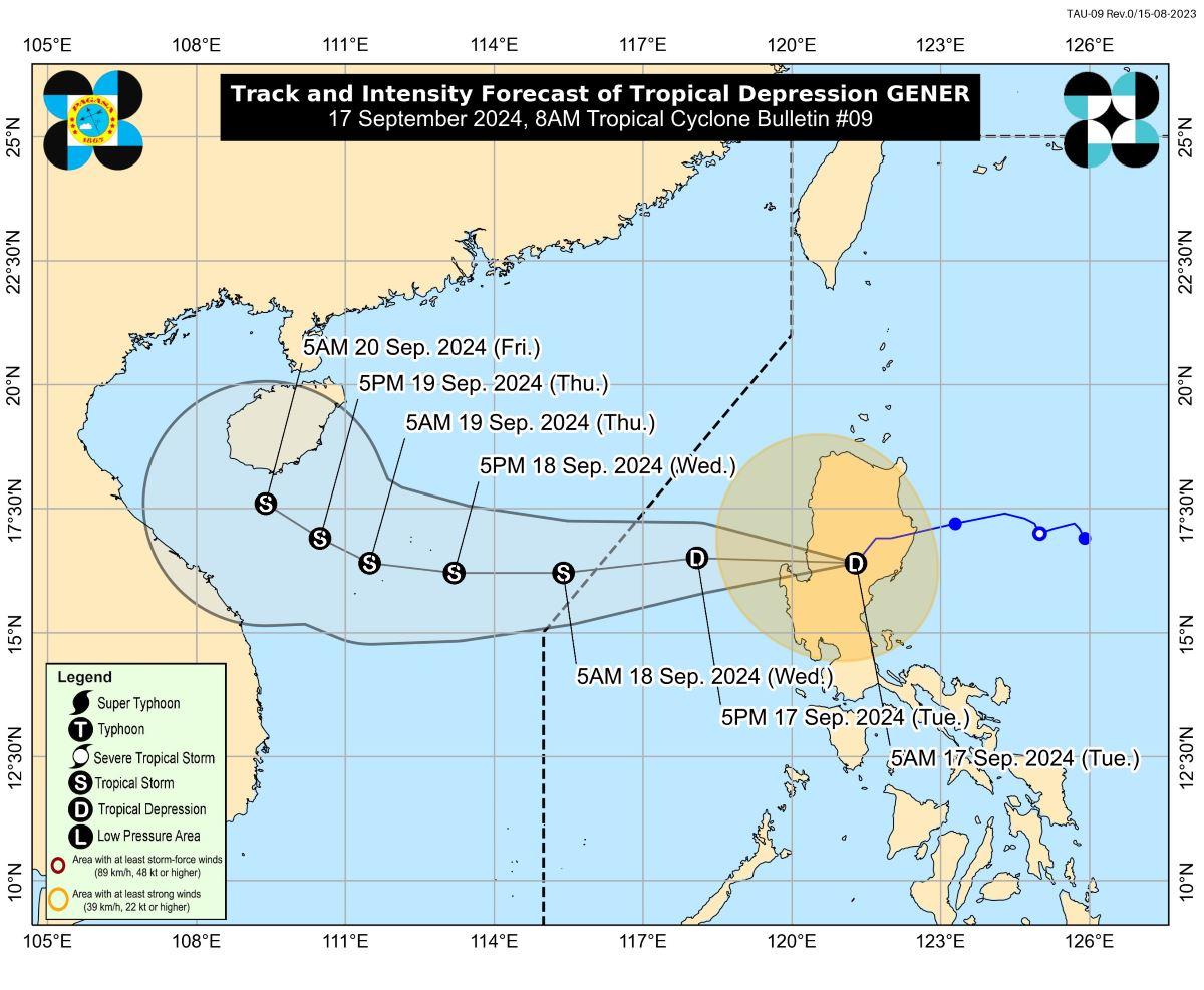
PAGASA said the center of the eye of Gener was last spotted in the vicinity of Ambaguio, Nueva Vizcaya.
It has a maximum sustained winds of 55 km/h near the center, gustiness of up to 70 km/h, and central pressure of 998 hPa.
It was moving southwestward at 15 km/h, and has strong winds which extended outwards up to 330 km from the center.
Winds, coastal waters
According to PAGASA, the Southwest Monsoon (Habagat) enhanced by Gener and Tropical Storm Pulasan will bring strong to gale-force gusts over Batanes, Mimaropa, Bicol Region, Visayas, and Mindanao within the day.
A gale warning is also in effect over several coastal waters in the northern seaboard of Northern Luzon, the western and southern seaboards of Southern Luzon, the seaboards of Visayas, and the western, northern, and eastern seaboards of Mindanao.
Up to rough seas (1.5 to 3.0 meters) may be expected over the following coastal waters:
- the eastern seaboard of Bicol Region
- the seaboard of Visayas outside Gale Warning areas, and
- the eastern seaboards of Caraga Region and Davao Region.
Meanwhile, the remaining seaboards of the country outside gale warning areas may experience up to moderate seas (up to 2.5 meters).
Track, intensity
Gener is seen to emerge over the coastal waters of Ilocos Sur or La Union on Tuesday, and will then move generally westward over the West Philippine Sea until Thursday before turning west northwestward as it heads towards southern China.
The tropical cyclone may exit the Philippine Area of Responsibility (PAR) between Tuesday night and Wednesday morning, said PAGASA.
It may also weaken into a Low Pressure Area in the next 12 hours as it continues to interact with the rugged terrain of Northern Luzon.
However, as it emerges over the coastal waters of Ilocos Sur or La Union, it may reach tropical storm category on early Wednesday morning and may further intensify over the West Philippine Sea.
Walang pasok
Classes for Tuesday, September 17, 2024 have been suspended in some areas due to the effects of Gener and the enhanced Southwest Monsoon or Habagat. —Giselle Ombay/KG, GMA Integrated News
