

PAGASA: Gener keeps strength; Signal No. 1 in 21 areas
A total of 21 areas are under Signal No. 1 as Tropical Depression Gener approaches Northern Luzon while maintaining its strength, PAGASA said.
According to the state weather bureau's 11 p.m. bulletin, Signal No. 1 is hoisted over these areas:
- Cagayan including Babuyan Islands
- Isabela
- Quirino
- Nueva Vizcaya
- Apayao
- Kalinga
- Abra
- Ifugao
- Mountain Province
- Benguet
- Ilocos Norte
- Ilocos Sur
- La Union
- Pangasinan
- Zambales
- Tarlac
- Nueva Ecija
- The northern portion of Bulacan (Doña Remedios Trinidad, San Miguel, San Ildefonso, Baliuag, San Rafael)
- The northern portion of Pampanga (Porac, Angeles City, Magalang, Arayat, Mabalacat City, Floridablanca, Santa Rita, Guagua, Bacolor, City of San Fernando, Mexico, Santa Ana, Candaba, San Luis, San Simon, Santo Tomas, Apalit, Minalin)
- Aurora
- The northern portion of Quezon (General Nakar, Infanta, Real) including Polillo Islands
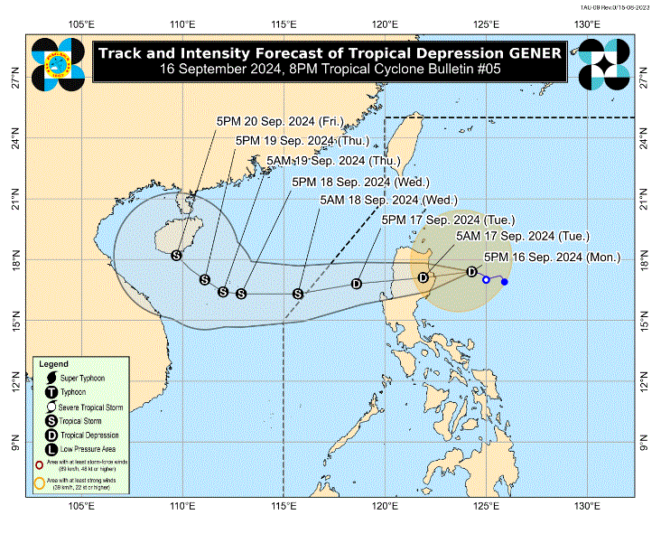
PAGASA said that Gener was moving westward at 25 kilometers per hour, with maximum sustained winds of 55 kph near the center and gustiness of up to 70 kph.
The tropical depression is forecast to make landfall in the vicinity of Isabela or Aurora on Monday evening, or early morning of Tuesday, and may likely emerge over the coastal waters of Ilocos Sur, La Union, or Pangasinan.
“Gener will likely cross the landmass of mainland Luzon as a tropical depression, although the possibility of reaching tropical storm category or slight weakening prior to landfall is not ruled out. Over the West Philippine Sea, GENER may reach tropical storm category tomorrow evening or on Wednesday morning,” state meteorologists said.
Gener may exit the Philippine Area of Responsibility between Tuesday evening and Wednesday morning, PAGASA added.
Meanwhile, Tropical Storm Pulasan, which remains far from the Philippine landmass, will remain a tropical storm throughout the forecast. But PAGASA said that it is not yet ruling out the possibility of it intensifying into a severe tropical storm.
Further, Pulasan may enter PAR on Tuesday evening as it moves generally northwestward at a fast speed. —LDF, GMA Integrated News
