

Signal No. 1 up over 19 areas as Gener slightly intensifies
Tropical Cyclone Wind Signal (TCWS) No. 1 was raised over 19 areas in Luzon as Tropical Depression Gener slightly intensified on Monday morning, state weather bureau PAGASA said.
In its 11 a.m. bulletin, PAGASA said the following areas are under TCWS No. 1:
- Cagayan including Babuyan Islands
- Isabela
- Quirino
- Nueva Vizcaya
- Apayao
- Kalinga
- Abra
- Ifugao
- Mountain Province
- Benguet
- Ilocos Norte
- Ilocos Sur
- La Union
- Pangasinan
- Zambales
- Tarlac
- Nueva Ecija
- Aurora
- the northern portion of Quezon (General Nakar, Infanta, Real) including Polillo Islands
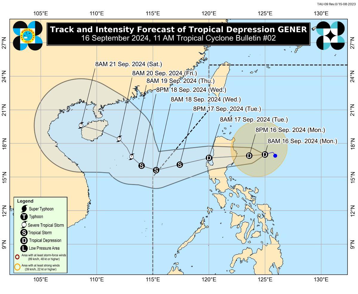
PAGASA said Gener was located 325 kilometers east northeast of Casiguran, Aurora, packing maximum sustained winds of 55 km per hour near the center and gustiness of up to 70 kph.
The tropical cyclone was moving west southwestward slowly, according to PAGASA.
Gener is expected to make landfall in the vicinity of Isabela or Aurora within the next 24 hours and may likely emerge over the coastal waters of La Union or Pangasinan on Tuesday morning.
“GENER will likely cross the landmass of mainland Luzon as a tropical depression, although the possibility of reaching tropical storm category prior to landfall is not ruled out,” PAGASA said.
“Over the West Philippine Sea, GENER may reach tropical storm category by tomorrow evening or on Wednesday,” it added.
Gener may exit the Philippine area of responsibility between late Tuesday evening and Wednesday morning, PAGASA said.
Rains
Due to Gener, heavy to intense rains are expected over Cagayan, Isabela, Quirino, and Aurora in the next 24 hours.
Moderate to heavy rains may be encountered over the rest of Cagayan Valley, the rest of Cordillera Administrative Region, Ilocos Norte, Nueva Ecija, and Bulacan.
Due to the Southwest Monsoon or Habagat, heavy to intense may be experienced in Palawan, Occidental Mindoro, Aklan, Antique, and Negros Occidental.
Meanwhile, moderate to heavy rains may prevail over the rest of MIMAROPA, the rest of Western Visayas, the rest of Negros Island Region (NIR), Quezon, Camarines Norte, and Camarines Sur.
Minimal to minor impacts from strong winds are possible within areas under TCWS No. 1, PAGASA said.
Due to Habagat enhanced by Gener and Pulasan, which is outside the PAR, strong to gale-force gusts may be experienced over MIMAROPA, Bicol, the Visayas, Zamboanga Peninsula, Northern Mindanao, Caraga, and Davao Region.
Gale Warning is in effect over the western and southern seaboards of Southern Luzon, the seaboards of Visayas, and the western, northern, and eastern seaboards of Mindanao, PAGASA said.
“Sea travel is risky for small seacrafts, including all types of motorbancas. For more information, refer to Gale Warning No. 4 issued at 5:00 AM this morning,” it added.
Moderate to rough seas of up to 3.5 meters are expected over the seaboards of Northern Luzon, Central Luzon, and the eastern seaboards of Southern Luzon.
“Mariners of small seacrafts, including all types of motorbancas, are advised not to venture out to sea under these conditions, especially if inexperienced or operating ill-equipped vessels,” PAGASA said.
Moderate seas of up to 2.5 meters may be encountered over the remaining seaboards of the country outside Gale Warning areas.
“Mariners of motorbancas and similarly-sized vessels are advised to take precautionary measures while venturing out to sea and, if possible, avoid navigation under these conditions,” PAGASA
Pulasan now a storm
In a separate 11 a.m. bulletin, PAGASA said Tropical Cyclone Pulasan, which is outside the PAR, intensified into a storm.
Pulasan was located 2,215 kilometers east of southeastern Luzon, packing maximum sustained winds of 65 km per hour near the center and gustiness of up to 80 kph.
The tropical storm was moving north northeastward at 20 km/h.
“PULASAN is forecast to enter the PAR around tomorrow evening (17 September) and may exit PAR around Wednesday morning...The possibility of further intensification is not ruled out, considering that the weather disturbance is still over the Pacific Ocean," PAGASA said.
"Having a similar track to that of BEBINCA (formerly “FERDIE”), current track scenario shows that the PULASAN will not directly affect any part of the country throughout the forecast period,” it added.—Joviland Rita/KG/AOL, GMA Integrated News
