

Habagat, LPA east of Cagayan to bring rains; storm to enter PAR Tuesday
The Southwest Monsoon or Habagat and a Low Pressure Area (LPA) located east of Cagayan will bring rains over several areas on Monday, PAGASA said. A storm meanwhile is forecast to enter the Philippine Area of Responsibility (PAR) on Tuesday.
The northern portion of Palawan, Occidental Mindoro, Aklan, Antique, and Negros Occidental will have monsoon rains due to the Southwest Monsoon affecting Southern Luzon, Visayas and Mindanao. Heavy to intense rains may possibly lead to flash floods or landslides.
The rest of MIMAROPA, Western Visayas, and Negros Island Region will experience occasional rains due to the monsoon. Moderate to heavy rains may possibly result in flash floods or landslides.
Ilocos Region, Cordillera Administrative Region, Cagayan Valley, and Aurora will have cloudy skies with scattered rains and thunderstorms due to the LPA. Flash floods or landslides may possibly result due to moderate to at times heavy rains.
Metro Manila, Zamboanga Peninsula, BARMM, SOCCSKSARGEN, Caraga, Northern Mindanao, and the rest of Luzon and Visayas may experience cloudy skies with scattered rains and thunderstorms due to the Southwest Monsoon. Moderate to at times heavy rains may possibly result in flash floods or landslides.
The rest of Mindanao on the other hand will have partly cloudy to cloudy skies with isolated rainshowers or thunderstorms due to the monsoon. During severe thunderstorms, flash floods or landslides may result.
At 3 a.m. on Monday, the LPA was estimated to be located at 375 km east northeast of Casiguran, Aurora or 400 km east of Tuguegarao City, Cagayan.
Coastal waters will be rough in Visayas, the western section of Southern Luzon, and the western, northern, and eastern sections of Mindanao, and moderate to rough in the rest of Southern Luzon and Mindanao.
The rest of Luzon will have slight to moderate coastal waters.
Sunrise was at 5:45 a.m. while sunset will be at 5:57 p.m.
Storm Pulasan
PAGASA said the tropical depression located outside the PAR intensified into a tropical storm with international name "Pulasan".
At 4 a.m., the center of Pulasan was estimated to be located at 2,215 km east of Southeastern Luzon.
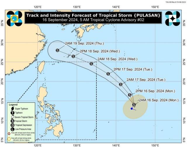
Pulasan has maximum sustained winds of 65 km/h near the center, gustiness of up to 80 km/h, and central pressure of 998 hPa.
It is moving north northeastward at 20 km/h, following the similar track of Bebinca, which was known as Ferdie when it was inside PAR.
Pulasan's forecast track shows it will not directly affect any part of the country.
From Pulasan's center, strong to gale-force winds are extending outwards up to 380 km.
PAGASA said Pulasan is expected to enter PAR on Tuesday evening and exit PAR on Wednesday morning.
The weather bureau advised the public and disaster risk reduction and management offices concerned to continue monitoring its updates related to Pulasan.
The next advisory will be issued at 11 a.m. —KG, GMA Integrated News
