

Ferdie exits PAR but Habagat, Bebinca trough to bring rains
Tropical Storm Ferdie (international name: Bebinca) exited the Philippine Area of Responsibility (PAR) but its trough or extension and the Southwest Monsoon (Habagat) will bring rains on Saturday, PAGASA said.
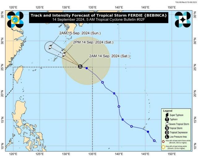
Ferdie left PAR at 2 a.m. on Saturday and at 4 a.m., its center was estimated to be located at 1,210 km east northeast of Extreme Northern Luzon.
It has maximum sustained winds of 85 km/h near the center, gustiness of up to 105 km/h, and central pressure of 992 hPa.
The storm was moving west northwestward at 20 km/h and is expected to move towards Okinawa, Japan then west northwestward over the East China Sea.
From its center though, strong to gale-force winds are extending outwards up to 680 km.
"Kahit na nasa labas na ito ng ating PAR, makikita dito sa ating latest satellite images ang makakapal na kaulapan na umiiral sa malaking bahagi ng ating bansa. [Ito] ay ang patuloy na epekto ng Southwest Monsoon o Habagat na hinahatak ng bagyo," PAGASA weather specialist Daniel James Villamil said in a press briefing.
(Even if it is already outside PAR, we can see in our latest satellite images the thick clouds prevailing in a big part of our country, the effect of the Southwest Monsoon or Habagat being enhanced by the storm.)
Mimaropa, Western Visayas, and Negros Occidental will have monsoon rains, with the possibility of flash floods or landslides due to heavy to intense rains.
Bicol Region and the rest of Negros Island Region may expect occasional rains due to the monsoon. Moderate to heavy rains may possibly lead to flash floods or landslides.
Metro Manila, the rest of Visayas, Zamboanga Peninsula, BARMM, SOCCSKSARGEN, Caraga, Northern Mindanao, CALABARZON, Zambales, and Bataan will experience cloudy skies with scattered rains and thunderstorms due to the Southwest Monsoon. Flash floods or landslides may result from moderate to at times heavy rains.
The rest of Mindanao will have partly cloudy to cloudy skies with isolated rain showers or thunderstorms also due to the monsoon. During severe thunderstorms, flash floods or landslides may result.
Meanwhile, the rest of Luzon is being affected by the trough or extension of Bebinca. These areas will have partly cloudy to cloudy skies with isolated rain showers or thunderstorms, with flash floods or landslides possibly occurring during severe thunderstorms.
Winds
Strong to gale-force gusts will be felt today in the following areas, but especially in coastal and upland areas exposed to winds, due to the Southwest Monsoon: Batangas, MIMAROPA, Bicol Region, Visayas, Caraga Region, Northern Mindanao, Zamboanga Peninsula, BARMM, and Davao Region, PAGASA said.
On Sunday, Batangas, MIMAROPA, Bicol Region, Visayas, Caraga Region, Northern Mindanao, Zamboanga Peninsula, BARMM, and Davao Region will also have strong to gale-force gusts.
On Monday, strong to gale-force gusts are also forecast for MIMAROPA, Bicol Region, Visayas, Caraga Region, Northern Mindanao, Zamboanga Peninsula, and Davao Region.
Seas
Coastal waters will be moderate to rough in:
- the western seaboards of Palawan and Occidental Mindoro;
- the western seaboard of Western Visayas, the western and southern seaboards of Negros Island Region, the southern seaboard of Central Visayas, the southern seaboard of Eastern Visayas, the seaboard of Caraga Region, the seaboard of Northern Mindanao, the northern and western seaboards of Zamboanga Peninsula, the eastern seaboard of Davao Region, and the remaining seaboards of Palawan;
- the eastern seaboard of Eastern Visayas; and
- the northern seaboard of Ilocos Region, the northern seaboard of Cagayan Valley, the southern seaboard of Quezon, the seaboards of Bicol Region, and the remaining seaboards of MIMAROPA, Visayas, Davao Region, and Zamboanga Peninsula.
"Mariners of small seacrafts, including all types of motorbancas, are advised not to venture out to sea under these conditions, especially if inexperienced or operating ill-equipped vessels," PAGASA said.
Meanwhile, moderate seas will be experienced in the remaining seaboards of the country.
"Mariners of motorbancas and similarly-sized vessels are advised to take precautionary measures while venturing out to sea and, if possible, avoid navigation under these conditions," the weather bureau said.
Sunrise was at 5:45 a.m. while sunset will be at 5:58 p.m.
Classes were suspended on Saturday in several areas due to the inclement weather.
Bad weather caused by the enhanced Southwest Monsoon led to flooding as well as mudslide and landslide in some towns in Palawan on Friday. Pre-emptive evacuation was implemented in a coastal area.
PAGASA advised the public and disaster risk reduction and management offices concerned to take the necessary measures to protect life and property. —KG, GMA Integrated News
