

Enteng accelerates, now over West Philippine Sea; Signal No. 2 remains over 7 areas
Tropical Storm Enteng (international name: Yagi) accelerated over Northern Luzon and is now over the West Philippine Sea, as Tropical Cyclone Wind Signal (TCWS) No. 2 remains over seven areas, PAGASA said early Tuesday morning.
TCWS No. 2 was hoisted at 5 a.m. over the following areas:
- Ilocos Norte;
- the northern portion of Ilocos Sur (Sinait, Cabugao, San Juan, Magsingal, Santo Domingo, San Ildefonso, San Vicente, Santa Catalina, City of Vigan, Bantay, Santa, Caoayan);
- Apayao;
- Abra;
- Kalinga;
- the western portion of Mainland Cagayan (Piat, Santo Nino, Camalaniugan, Tuao, Pamplona, Alcala, Amulung, Buguey, Solana, Rizal, Claveria, Iguig, Lasam, Aparri, Ballesteros, Abulug, Allacapan, Sanchez-Mira, Santa Praxedes); and
- Babuyan Islands (Calayan Is., Dalupiri Is., and Fuga Is.).
Minor to moderate impacts from strong winds are possible within any of the localities where TCWS No. 2 is hoisted, PAGASA said.
TCWS No. 1 meanwhile was raised over:- the rest of Ilocos Sur;
- the northern portion of La Union (Luna, Santol, San Juan, Bagulin, Bangar, San Gabriel, Bacnotan, Sudipen, Balaoan);
- Mountain Province;
- Ifugao;
- the northern portion of Benguet (Mankayan, Kapangan, Atok, Kabayan, Kibungan, Bakun, Buguias, Tublay);
- Batanes;
- the rest of Mainland Cagayan;
- the rest of Babuyan Islands;
- Isabela;
- the northern portion of Nueva Vizcaya (Bayombong, Ambaguio, Bagabag, Villaverde, Diadi, Quezon, Solano); and
- the northern portion of Quirino (Aglipay, Saguday, Diffun, Cabarroguis).
Minimal to minor impacts from strong winds are possible within any of the areas under TCWS No. 1, the weather bureau said.
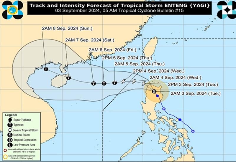
At 4 a.m., the center of Enteng was estimated to be located over the coastal waters of Paoay, Ilocos Norte, packing maximum sustained winds of 75 km/h near the center and with gustiness of up to 125 km/h.
Enteng is moving northwestward at 25 km/h.
Heavy rainfall outlook
Forecast accumulated rainfall is as follows:
- 100-200 mm: Ilocos Region
- 50-100 mm: Cagayan Valley and Cordillera Administrative Region
Enhanced Southwest Monsoon
Meanwhile, Enteng is enhancing the Southwest Monsoon (Habagat) which is forecasted to bring moderate to intense rainfall in other areas of Luzon, especially along the western portions over the next three days.
The monsoon will also bring strong to gale-force gusts over the following areas (especially in coastal and upland areas exposed to winds): Ilocos Region, Nueva Vizcaya, Quirino, Zambales, Bataan, Aurora, Bulacan, Metro Manila, Calabarzon, Mimaropa, Bicol Region, Western Visayas, Negros Island, and Northern Samar.
Minimal to moderate risk of storm surge may occur in the next 48 hours in the low-lying or exposed coastal localities of Cagayan, Isabela, Ilocos Norte, and Ilocos Sur.
Hazards affecting coastal waters
PAGASA reported that Enteng and the enhanced Southwest Monsoon will bring the following conditions over the coastal waters of the country:
- Gale Warning is in effect over the seaboards of Northern Luzon and the eastern seaboard of Central Luzon. Sea travel is risky for small seacraft, including all types of motor bancas.
- Rough seas over the western seaboard of Northern Luzon outside Gale Warning areas (2.5 to 4.0 m). Moderate to rough seas over the western seaboard of Central Luzon (1.5 to 3.0 m), the seaboards of Southern Luzon (2.0 to 3.5 m), and the western seaboard of Visayas (1.5 to 2.5 m). Mariners of small seacraft, including all types of motor bancas, are advised not to venture out to sea under these conditions, especially if inexperienced or operating ill-equipped vessels.
- Slight to moderate seas are expected over the eastern seaboards of Visayas and Mindanao (1.0 to 2.0 m). Mariners of motor bancas and similarly-sized vessels are advised to take precautionary measures while venturing out to sea and, if possible, avoid navigation under these conditions.
Track and intensity outlook
Enteng is forecast to continue moving generally west northwestward over the next 24 hours and is expected to turn westward over the West Philippine Sea starting Wednesday until it reaches Hainan, China on Saturday (7 September), PAGASA said.
On the track forecast, Enteng may exit the Philippine Area of Responsibility by Wednesday morning.
Effects
Government work and classes in private and public schools in the National Capital Region and Region IV-A were suspended on Tuesday, September 3, due to bad weather.
Classes in other areas were also suspended on Tuesday due to the effects of Enteng.
Some flights for Tuesday, September 3, were also canceled due to inclement weather.
Meanwhile, the Metropolitan Manila Development Authority suspended the implementation of the expanded number coding scheme on Tuesday, September 3 due to the inclement weather caused by Enteng and the enhanced Southwest Monsoon. —BAP/KG, GMA Integrated News
