

PAGASA sees another tropical cyclone to develop, enter PAR next week
Another tropical cyclone (TC) is seen to develop and enter the Philippine Area of Responsibility (PAR) next week, state weather bureau PAGASA said in a forecast on Monday.
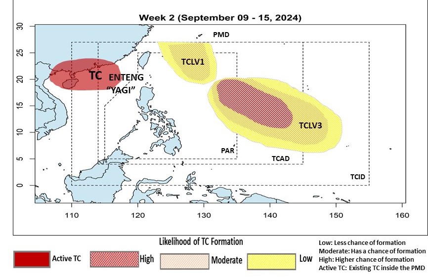
PAGASA said TC-like vortex (LV) 3 may develop over the eastern portion of its monitoring domain, with a “high likelihood” of developing into a tropical cyclone.
PAGASA also spotted two other TCLVs, one of which is inside PAR.
“TCLV1 will develop over the northern section of the PAR with a low chance of TC development,” PAGASA said.
But it is seen to move northward with an increased chance of forming into a TC over the northern portion of PAR, it added.
Meanwhile, TCLV2 will be formed over the northeastern portion of the Tropical Cyclone Advisory Domain (TCAD) with a low to moderate chance of TC formation, the state weather bureau said.
According to PAGASA, tropical cyclones within the TCAD are too far away to have any direct effect on the country but are close enough for monitoring.
Tropical Cyclone Wind Signal (TCWS) No. 2 is still raised over nine areas in Luzon due to Tropical Storm Enteng.
While TCWS No. 1 is hoisted over Metro Manila and 24 other areas in Luzon.—Mariel Celine Serquiña/AOL, GMA Integrated News
