

Signal No. 2 up over 7 Luzon areas as Tropical Storm Enteng brings rains
Tropical Cyclone Wind Signal No. 2 was raised on Monday morning over seven areas in Luzon as Tropical Storm Enteng (international name: Yagi) was forecast to bring rains and gale-force winds, PAGASA said.
The areas under TCWS No. 2 are:
- the northeastern portion of Camarines Norte (Vinzons, San Lorenzo Ruiz, Talisay, Daet, Labo, Paracale, Jose Panganiban, San Vicente, Basud, Mercedes);
- the northeastern portion of Camarines Sur (Garchitorena, Caramoan, Presentacion, San Jose, Lagonoy, Tinambac, Siruma);
- the eastern portion of Cagayan (Pe, Gonzaga, Santa Teresita, Buguey, Lal-Lo, Gattaran, Baggao, Santa Ana, Lasam, Santo Nino, Alcala, Amulung, Solana, Iguig, Tuguegarao City, Enrile, Aparri, Ballesteros, Camalaniugan, Allacapan, Piat, Tuao, Rizal, Abulug, Pamplona) including Babuyan Islands;
- the eastern portion of Isabela (Santa Maria, Santo Tomas, Cabagan, Delfin Albano, Quirino, Gamu, Burgos, Luna, Reina Mercedes, City of Cauayan, Alicia, Echague, Jones, San Agustin, Angadanan, San Guillermo, San Pablo, Maconacon, Tumauini, Ilagan City, Palanan, Divilacan, San Mariano, Naguilian, Benito Soliven, Dinapigue, Cabatuan, Aurora, San Manuel, Mallig, Quezon, Roxas);
- Polillo Islands;
- the eastern portion of Quirino (Maddela); and
- the eastern portion of Kalinga (Rizal).
The above-mentioned areas will have gale-force winds ranging from 62 to 88 km/h in 24 hours which may pose minor to moderate threat to life and property.
TCWS No. 1 meanwhile was raised over:
- the southern portion of Batanes (Sabtang, Ivana, Uyugan, Mahatao, Basco);
- the eastern portion of Ilocos Norte (Nueva Era, Carasi, Vintar, Adams, Dumalneg, Pagudpud, Bangui);
- the eastern portion of Abra (Tineg, Lacub, Malibcong);
- Apayao;
- the rest of Kalinga (Tanudan, City of Tabuk, Balbalan, Pinukpuk, Rizal, Lubuagan);
- the eastern portion of Mountain Province (Barlig, Natonin, Paracelis);
- the eastern portion of Ifugao (Banaue, Hingyon, Lagawe, Lamut, Mayoyao, Alfonso Lista, Aguinaldo);
- the rest of Cagayan;
- the rest of Isabela;
- the rest of Quirino;
- the eastern portion of Nueva Vizcaya (Alfonso Castaneda, Kasibu, Dupax del Norte, Bagabag, Diadi, Quezon, Villaverde, Solano, Bayombong, Ambaguio, Aritao, Bambang, Dupax del Sur);
- the rest of Aurora;
- the eastern portion of Nueva Ecija (General Tinio, Gabaldon, Palayan City, General Mamerto Natividad, Llanera, San Jose City, Carranglan, Pantabangan, Bongabon, Rizal, Laur);
- the eastern portion of Bulacan (Do, Norzagaray);
- the eastern portion of Rizal (Jala-Jala, Pililla, Tanay, Baras, City of Antipolo, Rodriguez, Teresa, Morong);
- the eastern portion of Laguna (Luisiana, Majayjay, Magdalena, Pagsanjan, Santa Cruz, Lumban, Cavinti, Kalayaan, Paete, Siniloan, Santa Maria, Famy, Pangil, Mabitac, Pakil);
- the northern and southern portions of Quezon (Tagkawayan, Guinayangan, Buenavista, San Narciso, Mulanay, San Andres, San Francisco, Lopez, Calauag, Catanauan, Gumaca, Macalelon, General Luna, Quezon, Alabat, Perez, General Nakar, Infanta, Real, Mauban, Unisan, Pitogo, Padre Burgos, Atimonan, Agdangan, Plaridel, Lucban, Sampaloc, City of Tayabas, Lucena City, Pagbilao);
- Marinduque;
- the rest of Camarines Norte;
- the rest of Camarines Sur;
- Albay;
- Sorsogon;
- Catanduanes; and
- the northern portion of Masbate (City of Masbate, Aroroy, Baleno) incuding Ticao and Burias Islands.
Areas under TCWS No. 1 will have strong winds ranging from 39 to 61 km/h in 36 hours which may pose minimal to minor threat to life and property.
"The highest possible Wind Signal that may be hoisted during the passage of ENTENG is Wind Signal No. 3," PAGASA said.
Location
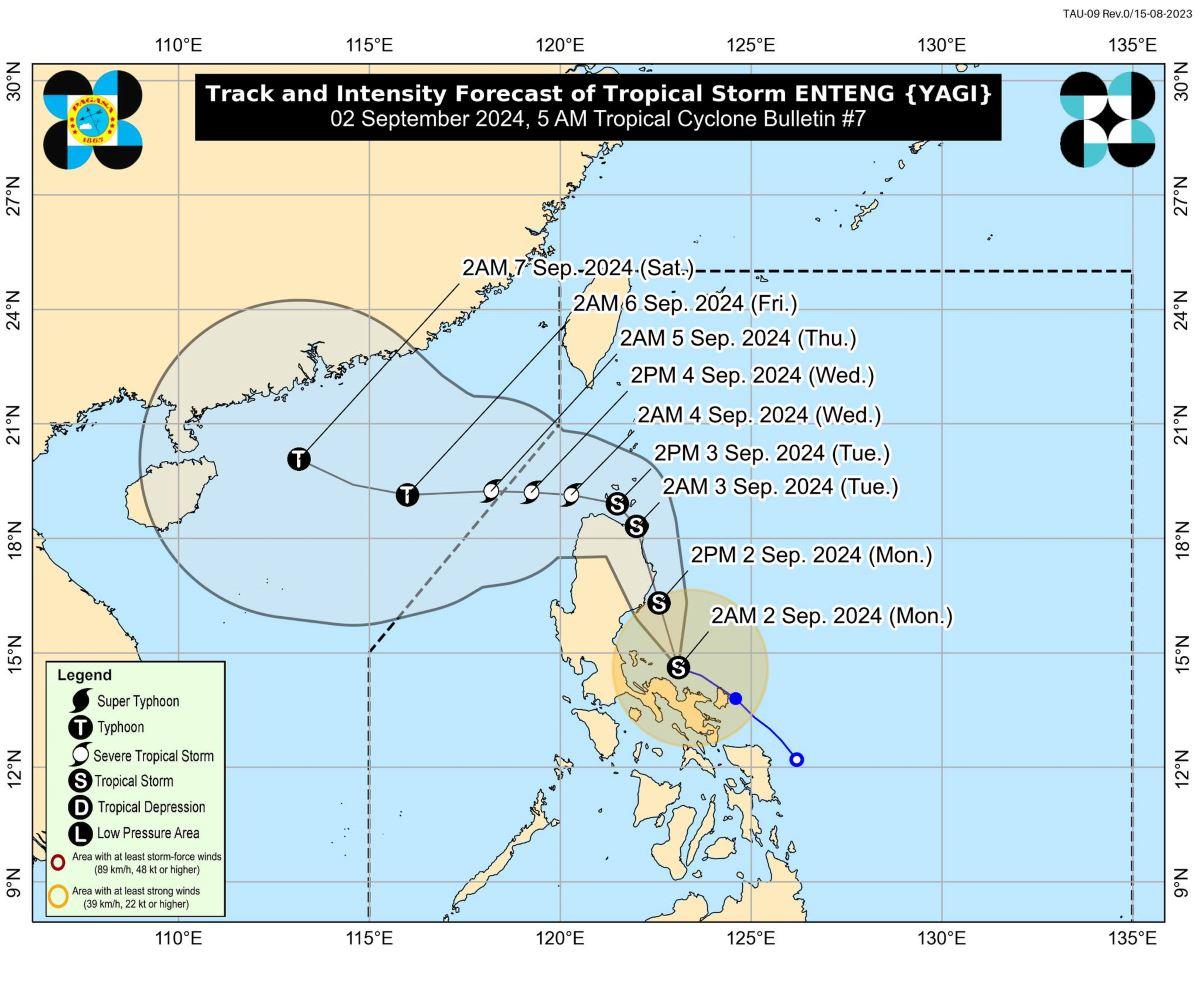
At 4 a.m. on Monday, the center of Enteng was estimated to be located over the coastal waters of Vinzons, Camarines Norte.
It slightly intensified as it decelerated while over the coastal waters.
Enteng was packing maximum sustained winds of 75 km/h near the center, gustiness of up to 90 km/h, and central pressure of 998 hPa.
The tropical storm is moving west northwest at 10 km/h.
From Enteng's center, strong to gale-force winds are extending outwards up to 250 km.
Rainfall, winds
On Monday, more than 200 mm of rain are expected to pour over Camarines Norte, Camarines Sur, Albay, Polillo Island, and the southern portion of mainland Quezon.
Aurora, the rest of Quezon, Catanduanes, Masbate, and Sorsogon will have 100 to 200 mm of rain, while Isabela, Quirino, Bulacan, Metro Manila, the rest of CALABARZON, Marinduque, and Romblon may expect 50 to 100 mm of rainfall.
On Tuesday, accumulated rainfall forecast is as follows:
• 100-200 mm: Isabela, Cagayan, Abra, Apayao, and Ilocos Norte
• 50-100 mm: Aurora and the rest of Ilocos Region, the rest Cordillera Administrative Region, and mainland Cagayan Valley
On Wednesday, below is the rainfall forecast:
• 100-200 mm: Babuyan Islands, Apayao, Abra, Ilocos Norte, and Ilocos Sur
• 50-100 mm: Batanes, mainland Cagayan, and the rest of Cordillera Administrative Region and Ilocos Region.
"Forecast rainfall are generally higher in elevated or mountainous areas. Under these conditions, flooding and rain-induced landslides are expected especially in areas that are highly or very highly susceptible to these hazards as identified in official hazard maps and in localities that experienced considerable amounts of rainfall for the past several days," PAGASA said.
The weather bureau said Enteng is enhancing the Southwest Monsoon (Habagat) which will bring moderate to intense rainfall in other areas in Luzon and Visayas, especially in the western portions.
Strong to gale-force gusts are expected over the following areas due to the enhanced Habagat:
• Today: Ilocos Region, Zambales, Bataan, Pampanga, Aurora, Bulacan, Metro Manila, CALABARZON, MIMAROPA, Bicol Region, and Visayas
• Tomorrow (3 September): Zambales, Bataan, Aurora, Bulacan, Metro Manila, CALABARZON, MIMAROPA, Bicol Region, and Visayas.
• Wednesday (4 September): Zambales, Bataan, Aurora, Bulacan, Metro Manila, CALABARZON, MIMAROPA, Bicol Region, and Western Visayas.
Coastal areas
A gale warning is in effect on Monday over the eastern seaboard of Luzon and the southern seaboard of Southern Luzon.
"Sea travel is risky for small seacrafts, including all types of motorbancas," PAGASA said.
The northern seaboard of Northern Luzon and the western seaboard of Central Luzon, the western seaboard of Southern Luzon and the seaboards of Western Visayas will have moderate to rough seas.
"Mariners of small seacrafts, including all types of motorbancas, are advised not to venture out to sea under these conditions, especially if inexperienced or operating ill-equipped vessels," PAGASA said.
The rest of the country meanwhile will have slight to moderate seas.
Track, intensity outlook
In the next 24 hours, Enteng is expected to move generally northwestward.
The tropical storm may possibly make landfall over Isabela or Cagayan on Monday afternoon or evening.
However, if Enteng shifts its track, landfall over the northern portion of Aurora may be possible.
Starting Tuesday early morning, Enteng will generally turn west northwestward.
"Possible landfall over Babuyan Islands is also not ruled out," PAGASA said.
Over Luzon Strait, Enteng may possibly decelerate on Tuesday to Wednesday.
It will then move west northwestward while accelerating.
Enteng may intensify into a severe tropical storm by Wednesday, then reach typhoon category by Thursday or Friday.
Enteng is expected to exit the Philippine Area of Responsibility by Wednesday evening to Thursday early morning.
PAGASA advised the public and disaster risk reduction and management offices concerned to take all necessary measures to protect life and property.
The weather bureau will issue the next bulletin at 8 a.m.
Effects
On Monday, classes were suspended in some areas and some flights were canceled due to the bad weather caused by Enteng and the enhanced Southwest Monsoon.
Malacañang also canceled Monday classes in all levels in public and private schools in the National Capital Region. —KG, GMA Integrated News
