

Carina crossing Taiwan; Signal No. 1 raised over Batanes
Typhoon Carina is crossing Taiwan and near the northern boundary of the Philippine Area of Responsibility (PAR) as Signal No. 1 remains over Batanes, according to the latest Typhoon Bulletin posted by PAGASA.
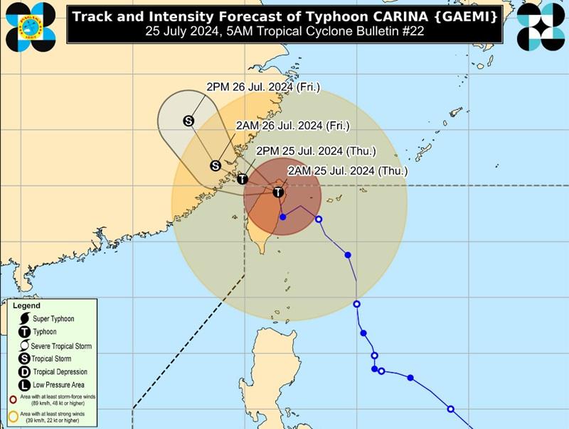
The center of the eye of Typhoon Carina was estimated at 465 kilometers north of Itbayat, Batanes or in the vicinity of Hsinchu County, Taiwan packing maximum sustained winds of 150 kilometers near the center, gustiness of up to 250 km/h, and central pressure of 960 hPa.
Carina is moving Northward at 20 km/h with strong to typhoon-force winds extend outwards up to 660 km from the center.
Tropical Cyclone Wind Signal No. 1 is hoisted over Batanes.
Typhoon Carina will bring rains with gusty winds over Batanes with the possibility that flash floods and landslides will occur due to moderate to heavy rains.
The weather bureau warned that minimal to minor threat to lives and properties is expected due to strong winds.
Heavy Rainfall Outlook
Typhoon Carina is now less likely to directly bring heavy rainfall over any portion of the country, PAGASA said.
However, the Southwest Monsoon enhanced by Carina will bring moderate to intense rainfall over various localities in the western portion of Luzon from Thursday through Saturday.
Metro Manila, Ilocos Region, Abra, Apayao, Benguet, Zambales, Bataan, Pampanga, Bulacan, and Occidental Mindoro will have monsoon rains due to the southwest monsoon with possible flooding or landslides due to heavy to intense rains with at times torrential rains.
The rest of Cordillera Administrative Region, the rest of CALABARZON, Tarlac, and Nueva Ecija will have occasional rains due to the southwest monsoon with flash floods or landslides possibly occurring due to moderate to intense rains.
Western Visayas and the rest of Luzon will have cloudy skies with scattered rains and thunderstorms due to the southwest monsoon with possible flash floods or landslides occurring due to moderate to at times heavy rains.
The rest of the country will have partly cloudy to cloudy skies with isolated rain showers or thunderstorms due to the southwest monsoon with possible flash floods or landslides occurring during severe thunderstorms.
Severe Winds
"Local winds may be slightly stronger/enhanced in coastal and upland/mountainous areas exposed to winds. Winds are less strong in areas sheltered from the prevailing wind direction," the weather bureau reported.
The southwest monsoon enhanced by Carina will also bring strong to gale-force gusts over the following areas (especially in coastal and upland areas exposed to winds) on Thursday and Friday: Batanes, Babuyan Islands, Ilocos Region, Cordillera Administrative Region, Nueva Vizcaya, Quirino, the eastern portion of Isabela, Central Luzon, Metro Manila, CALABARZON, MIMAROPA, Bicol Region, Western Visayas, Negros Occidental, and Northern Samar.
Hazards affecting coastal waters
"Gale Warning is in effect over the coastal waters of Batanes, Babuyan Islands, Ilocos Norte, Ilocos Sur, and northwestern Cagayan. Sea travel is risky for small seacrafts, including all types of motorbancas," said PAGASA.
Mariners of small seacrafts are warned that in the next 24 hours, Carina and the enhanced Southwest Monsoon will bring rough seas over the western seaboard of Central Luzon, moderate to rough seas are also expected over the northern and western seaboards of Northern Luzon outside Gale Warning areas, the western seaboard of Southern Luzon, and the eastern seaboard of Northern Luzon.
Meanwhile, mariners of motorbancas are advised are advised to take precautionary measures as moderate seas are also expected over the eastern seaboards of Central and Southern Luzon, the southern seaboard of Southern Luzon, the western and eastern seaboards of Visayas, and the eastern seaboard of Mindanao.
Track and Intensity Outlook
Typhoon Carina is forecast to exit the PAR region Thursday morning, cross the Taiwan Strait, and make its final landfall over southeastern China in the afternoon or evening and continue to weaken as it further interacts with the mountainous terrain of Taiwan and the landmass of southeastern.
Wind speed forecast
The wind speed forecast for Luzon and Visayas is moderate to strong moving southwestward while coastal waters will be moderate to rough.
Mindanao will experience moderate to strong moving in the south to southwest direction while coasra will be moderate to rough / (1.2 to 2.8 meters)
Sunrise will be at 5:38 a.m., sunset at 6:27 p.m. — BAP, GMA Integrated News
