

PAGASA: Carina now a super typhoon
Tropical cyclone Carina has become even stronger and is now a Super Typhoon, the state weather bureau PAGASA said on Wednesday afternoon.
PAGASA defines a super typhoon as a tropical cyclone with a maximum wind speed of 185 km/h or above.
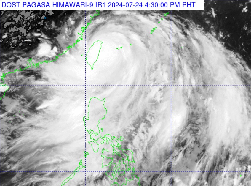
At 4 p.m., the center of the eye of Carina was spotted 380 km north of Itbayat, Batanes, carrying maximum sustained winds of 185 km/h near the center and gustiness of up to 230 km/h.
It was moving northwestward at 20 km/h.
Signal No. 2 was hoisted over Batanes while Signal No. 1 was raised over the following areas:
- Babuyan Islands
- the northern portion of mainland Cagayan (Claveria, Santa Praxedes, Sanchez-Mira, Pamplona, Abulug, Ballesteros, Aparri, Camalaniugan, Buguey, Santa Teresita, Santa Ana, Gonzaga)
- the northern portion of Ilocos Norte (Burgos, Bangui, Pagudpud, Dumalneg, Adams)
Due to the effects of the super typhoon, stormy conditions may be expected in Batanes, while the northern portion of Cagayan including Babuyan Islands and the northern portion of Ilocos Norte will see rains with gusty winds.
“Yung may warning, signals 2 and 1, patuloy pa rin na makakaranas ng masungit na panahon… Samantala, dahil nga sa patuloy na pagkilos nitong si Carina, natrack na very favorable for the continuous enhancement of Habagat,” said PAGASA Assistant Weather Services Chief Chris Perez in an interview on GMA Integrated News Bulletin.
(Areas under storm warning, signals 2 and 1, will continue to experience inclement weather… Meanwhile, because of the continuous movement of Carina, we have tracked that the continuous enhancement of Habagat is very favorable.)
The enhanced Southwest Monsoon will bring monsoon rains over Metro Manila, Abra, Benguet, Zambales, Bataan, Tarlac, Pampanga, Bulacan, Rizal, Occidental Mindoro, and the rest of Ilocos Region, and occasional rains over the rest of Cordillera Administrative Region, Nueva Ecija, and the rest of CALABARZON.
It will also cause cloudy skies with scattered rains and thunderstorms over Western Visayas, Negros Island Region, and the rest of Luzon, and partly cloudy to cloudy skies with isolated rain showers or thunderstorms over the rest of the country.
Flash floods and landslides may occur due to these weather conditions.
Several parts of the country, including Metro Manila, experienced massive flooding on Wednesday due to the Southwest Monsoon and Super Typhoon Carina.
Meanwhile, moderate to strong winds with moderate to rough coastal waters may be felt across the Philippines.
Carina was forecast to make landfall over the northern portion of Taiwan on Wednesday evening.
The super typhoon will then cross the rugged terrain of Taiwan and exit the Philippine Area of Responsibility (PAR) on Thursday morning.
''Carina has reached its peak intensity as Super Typhoon prior to its landfall over Taiwan due to favorable environment. Its landfall over northern Taiwan will trigger a weakening trend for the rest of the forecast period,'' PAGASA said. —NB/VBL, GMA Integrated News
