

Carina further intensifies, Signal No. 2 raised over Batanes
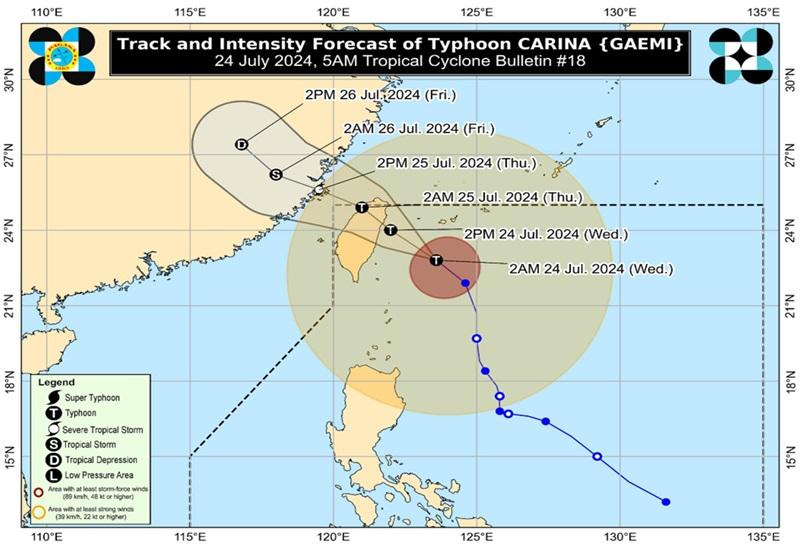
Typhoon Carina has further intensified early Wednesday morning as it continued to move towards Taiwan, according to the 5 a.m. Typhoon Bulletin posted by PAGASA.
The center of the eye of Typhoon Carina was estimated at 290 kilometers northeast of Itbayat, Batanes packing maximum sustained winds of 155 kilometers per hour near the center, gustiness of up to 190 km/h and moving northwestward at 25 km/h.
Tropical Cyclone Wind Signal (TCWS) No. 2 is hoisted over Batanes.
TCWS No. 1 is hoisted over the following areas:
- Babuyan Islands
- the northern portion of mainland Cagayan (Claveria, Santa Praxedes, Sanchez-Mira, Pamplona, Abulug, Ballesteros, Aparri, Camalaniugan, Buguey, Santa Teresita, Santa Ana, Gonzaga)
- the northern portion of Ilocos Norte (Burgos, Bangui, Pagudpud, Dumalneg, Adams)
Heavy Rainfall Outlook
Forecast accumulated rainfall over Batanes and Babuyan Islands is 50-100 mm on Wednesday and generally higher in elevated or mountainous areas.
"Under these conditions, flooding and rain-induced landslides are possible especially in areas that are highly or very highly susceptible to these hazards as identified in official hazard maps and in localities that experienced considerable amounts of rainfall for the past several days," PAGASA said.
The Southwest Monsoon enhanced by Carina will bring moderate to intense rainfall over various areas in the western portion of Luzon on Wednesday through Friday.
Batanes and Babuyan Islands will experience rains and gusty winds due to Typhoon Carina on Wednesday, PAGASA reported.
Flooding and landslides may occur in Batanes due to heavy to intense rains and minor threat to lives and properties due to strong winds.
In the Babuyan Islands, flash floods and landslides may occur doe to moderate to heavy with at times intense rains with minomal to minor threat to lives and properties due to strong winds.
Ilocos Region, Zambales, Bataan, Abra, Benguet, and Occidental Mindoro will have monsoon rains due to the southwest monsoon with possible flooding or landslides occurring due to scattered to widespread rains.
Metro Manila, the rest of Cordillera Administrative Region, Cavite, Batangas, Tarlac, Pampanga, Bulacan, Rizal, and Laguna will have occasional rains due to the southwest monsoon with possible flash floods or landslides occurring due to moderate to intense rains.
Western Visayas, Negros Island Region, and the rest of Luzon will have cloudy skies with scattered rains and thunderstorms due to the southwest monsoon with flash floods or landslides possibly occurring due to moderate to at times heavy rains.
The rest of the country will have partly cloudy to cloudy skies with isolated rain showers or thunderstorms due to the southwest monsoon with flash floods or landslides possibly occurring during severe thunderstorms.
Severe Winds
The wind signals warn the public of the general wind threat over an area due to the tropical cyclone. Local winds may be slightly stronger/enhanced in coastal and upland/mountainous areas exposed to winds. Winds are less strong in areas sheltered from the prevailing wind direction.
The Southwest Monsoon enhanced by CARINA will also bring strong to gale-force gusts over the following areas (especially in coastal and upland areas exposed to winds): Ilocos Region, Cordillera Administrative Region, Nueva Vizcaya, Quirino, the eastern portion of Isabela, Central Luzon, Metro Manila, CALABARZON, MIMAROPA, Bicol Region, Visayas, Zamboanga Peninsula, and Northern Mindanao
Hazards affecting coastal waters
The weather bureau raised the Gale Warning over the coastal waters of Batanes, Babuyan Islands, and the northern portion of Cagayan. Therefore, sea travel is risky for small seacrafts, including all types of motorbancas.
Mariners of small seacrafts, including all types of motorbancas, are warned against venturing out to sea as in the next 24 hours, Carina and the enhanced Southwest Monsoon will bring rough seas over the seaboards of Northern Luzon and the western seaboard of Central Luzon. Moderate to rough seas are also expected over the western seaboard of Southern Luzon and the eastern seaboards of Central and Southern Luzon.
Mariners are advised to take precautionary measures as moderate seas are also expected over the southern seaboard of Southern Luzon, the western and eastern seaboards of Visayas, and the eastern seaboard of Mindanao.
Track and intensity outlook
Carina is forecast to make landfall over the northern portion of Taiwan on Wednesday afternoon or early evening and exit the Philippine Area of Responsibility (PAR) tonight or early Thursday morning.
Wind speed forecast
The wind speed forecast for northern and eastern sections of Northern Luzon is moderate to strong moving in the northwest to southwest direction while coastal waters will be moderate to rough.
Visayas and the rest of Luzon will experience moderate to strong wind speed moving southwestward with moderate to rough coastal waters.
The wind speed forecast for Mindanao is moderate to strong moving in the south to southwest direction while coastal waters will be moderate to rough.
Sunrise will be at 5:37 a.m., sunset at 6:28 p.m.
Work, classes suspended
Due to the inclement weather, Malacañang has suspended government work and classes in the National Capital Region (NCR) for the day.
"In view of the forecasted continuous rainfall brought about by the Southwest Monsoon and Typhoon Carina at 05:00 a.m. today, 24 July 2024, as recommended by the National Disaster Risk Reduction and Management Council," according to an announcement from the Office of the Executive Secretary.
"However, those agencies whose functions involve the delivery of basic and health services, preparedness/response to disasters and calamities, and/or the performance of other vital services shall continue with their operations and render the necessary services."
Many areas outside NCR also suspended classes for Wednesday due to the weather.
Aside from work and class suspensions, several flights were also canceled for the day.
Meanwhile, the local government of Marikina has raised the second alarm in the Marikina River early Wednesday morning after heavy overnight rains caused the water level to swell.
Flooded areas
In NCR, several areas were flooded on Wednesday morning, according to the Metropolitan Manila Development Authority (MMDA). They are:
- As of 4:49 AM at C5 Julia Vargas NB/SB. Knee Deep. Not passable to light vehicles.
- As of 4:51 AM at España Lacson. Tire Deep. Not passable to light vehicles.
- As of 4:51 AM at España Lacson tire Deep. not passable to light vehicles
- As of 4:57 AM at EDSA Balintawak NB. Gutter Deep. Passable to light vehicles.
- As of 5:17 AM at EDSA Main Ave. NB. Knee deep. Not passable to light vehicles.
- As of 5:25 AM at Ortigas Rosario SB Half tire Deep. passable to light vehicles.
- As of 5:32 AM at C5 Eagle St. NB/SB Half tire Deep. passable to light vehicles.
- As of 5:38 AM at Don Manuel Banaue Knee Deep. Not passable to light vehicles
- As of 5:45 AM at Ortigas La Salle WB. Gutter deep. Passable to light vehicles.
- As of 5:48 AM at EDSA Dario NB Bridge. Gutter Deep. Passable to light vehicles.
The MMDA has already suspended the expanded number-coding scheme for the day. — BAP/KBK, GMA Integrated News
