

Batanes still under Signal No. 2 as Carina intensifies
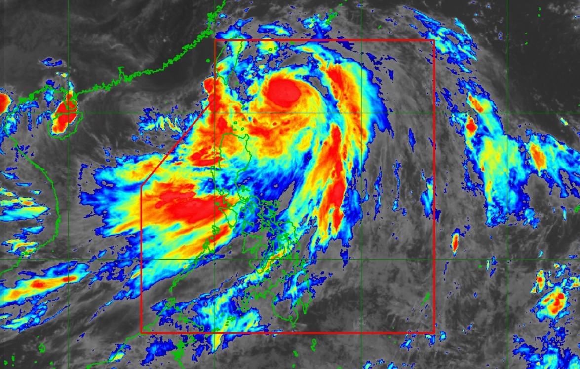
Typhoon Carina continues to intensify as it moves northward at 20 kph at 325 kilometers east northeast of Basco, Batanes.
According to PAGASA’s 5 p.m. cyclone bulletin on Tuesday, Carina has maximum sustained winds of 150 kph, gustiness of up to 185 kph, and central pressure of 960 hPa.
Strong to typhoon-force winds may extend outwards up to 540 kilometers from the center of the storm.
Batanes remains under tropical cyclone wind Signal No. 2 and will experience winds of 62 to 88 kph in at least 24 hours.
Residents in the area may expect gale-force winds and minor to moderate threat to life and property.
Meanwhile, the following areas under Signal No. 1 will be having strong winds of 39 to 61 kph in the next 36 hours:
- Cagayan including Babuyan Islands
- The eastern portion of Isabela (Divilacan, Palanan, Maconacon, Dinapigue, Tumauini, Ilagan City, San Mariano, Cabagan, San Pablo, Santa Maria)
- The northern portion of Apayao (Calanasan, Luna, Pudtol, Flora, Santa Marcela, Kabugao)
- The northern portion of Ilocos Norte (Pagudpud, Bangui, Adams, Dumalneg, Burgos, Vintar, Pasuquin, Bacarra, Carasi)
Said areas may expect minimal to minor threats to life and property.
Carina is also predicted to bring heavy rainfall in the following areas over the next three days.
Tuesday to Wednesday afternoon:
- 100 to 200 mm: Batanes, Babuyan Islands, the northern and eastern portion of Mainland Cagayan, and Ilocos Sur
- 50 to 100 mm: Ilocos Norte, La Union, Abra, Benguet, Apayao, the eastern portion of Isabela, and the rest of Cagayan
Wednesday afternoon to Thursday afternoon:
- 100 to 200 mm: Batanes
- 50 to 100 mm: Babuyan Islands
Enhanced monsoon
The Southwest Monsoon, enhanced by Typhoon Carina, will also bring moderate to intense rainfall over the western portion of Luzon until Thursday, and strong to gale-force gusts over the following areas within the next three days:
Tuesday: Ilocos Region, Abra, Benguet, Nueva Vizcaya, Quirino, Zambales, Bataan, Aurora, Metro Manila, CALABARZON, MIMAROPA, Bicol Region, Visayas, Zamboanga Peninsula, Northern Mindanao, and Davao Region
Wednesday: Babuyan Islands, Ilocos Region, Abra, Benguet, Nueva Vizcaya, Quirino, Central Luzon, Metro Manila, CALABARZON, MIMAROPA, Bicol Region, Visayas, Zamboanga Peninsula, and Northern Mindanao
Thursday: Batanes, Babuyan Islands, Ilocos Region, Cordillera Administrative Region, Nueva Vizcaya, Quirino, Central Luzon, Metro Manila, CALABARZON, MIMAROPA, Bicol Region, Western Visayas, Negros Occidental, and Northern Samar.
A gale warning has been placed over the coastal waters of Batanes, Babuyan Islands, and the northeastern portion of Cagayan, while the northern and eastern seaboards of Northern Luzon and the eastern seaboard of Central Luzon are warned to expect rough seas over the next 24 hours due to the effects of the Monsoon and typhoon.
The eastern seaboards of Southern Luzon, western seaboards of Luzon, the southern seaboards of Southern Luzon, the western and eastern seaboards of Visayas, and the eastern seaboard of Mindanao may also experience moderate to rough seas.
Typhoon Carina is predicted to stay far from the Philippine landmass and make landfall over the northern portion of Taiwan between Wednesday evening and Thursday morning before exiting the Philippine Area of Responsibility.
It may continue to intensify and reach its peak intensity before landfall.
PAGASA warns public and disaster risk reduction and management offices to take all necessary measures to “protect life and property”.
Carina, Habagat bring heavy rains
Due to Typhoon Carina, Batanes will experience stormy conditions, while Cagayan, Apayao, and Ilocos Norte will have rainy skies with gusty winds.
Cloudy skies with scattered rains and thunderstorms may also be expected over Aurora and parts of Cagayan Valley due to the typhoon.
The enhanced Southwest Monsoon may bring Monsoon rains over Metro Manila, Zambales, Bataan, Pampanga, Bulacan, Cavite, Batangas, Rizal, Occidental Mindoro, and the rest of Ilocos Region and Cagayan Valley, and occasional rains in Oriental Mindoro, Romblon, Laguna, Tarlac, Nueva Ecija, Aklan, Antique, and Northern Palawan including Calamian and Cuyo islands.
Negros Island Region, Zamboanga Peninsula, Quezon, Northern Samar, Basilan, Sulu, Tawi-Tawi, and the rest of Bicol Region, MIMAROPA, & Western Visayas will be having Cloudy skies with scattered rains and thunderstorms, as the rest of the country feels partly cloudy to cloudy skies with isolated rain showers or thunderstorms caused by the Southwest Monsoon.
Possible flash floods and landslides may occur in some areas of the country due to said weather conditions.
Moderate to rough winds with moderate to rough waters will be felt over the Philippines.
Sunrise in Metro Manila will be at 5:37 a.m. on Wednesday. —NB, GMA Integrated News
