

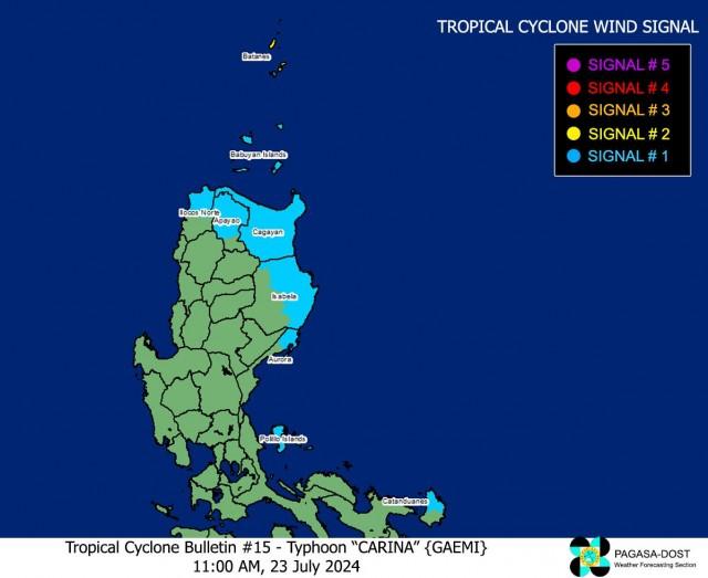
Carina slightly intensifies as Signal No. 2 raised over Batanes
Tropical Cyclone Wind Signal (TCWS) No. 2 was raised over Batanes as Typhoon Carina slightly intensified late Tuesday morning, according to state weather bureau PAGASA.
As of 11 a.m., PAGASA said Batanes (Itbayat, Basco, Mahatao, Uyugan, Ivana) may experience gale-force winds ranging 62 to 88 km/h within the next 24 hours.
Wind impacts may also result in minor to moderate threat to life and property.
Meanwhile, TCWS No. 1 was raised over the following areas:
- The rest of Batanes (Sabtang)
- Cagayan including Babuyan Islands
- Eastern portion of Isabela (Divilacan, Palanan, Maconacon, Dinapigue, Tumauini, Ilagan City, San Mariano, Cabagan, San Pablo, Santa Maria),
- Northern portion of Apayao (Calanasan, Luna, Pudtol, Flora, Santa Marcela),
- Northern portion of Ilocos Norte (Pagudpud, Bangui, Adams, Dumalneg, Burgos, Vintar),
- Northern portion of Aurora (Dilasag, Casiguran),
- Polillo Islands,
- Calaguas Islands
- Northern portion of Catanduanes (Pandan, Bagamanoc, Panganiban, Viga, Gigmoto, Caramoran)
Strong winds from 39 to 61 km/h may be expected in these areas within the next 36 hours. Wind impacts may result in minimal to minor threat to life and property.
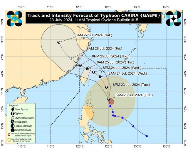
PAGASA said the center of Carina was estimated at 320 km east of Basco, Batanes or 405 km East Northeast of Aparri, Cagayan.
It has a maximum sustained winds of 140 km/h near the center, gustiness of up to 170 km/h, and central pressure of 965 hPa.
It was moving northward at 15 km/h, and it has strong to typhoon-force winds that extend outwards up to 520 km from the center.
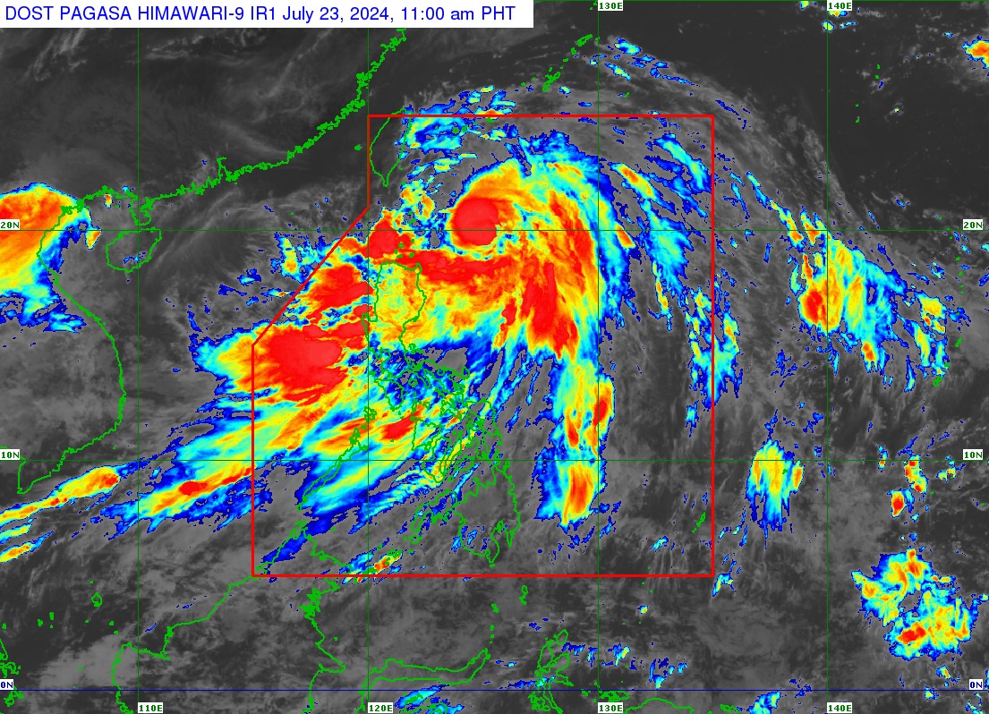
Carina caused severe flooding in parts of Luzon. It also caused cancellation of classes in parts of the country.
Rains, winds
On Tuesday up to Wednesday noon, PAGASA said that Batanes, Babuyan Islands, the northern and eastern portion of Mainland Cagayan, and Ilocos Sur may have 100-200 mm of accumulated rainfall.
Meanwhile, 50-100 mm may pour over Ilocos Norte, La Union, Abra, Benguet, Apayao, the eastern portion of Isabela, and the rest of Cagayan.
The Southwest Monsoon or Habagat being enhanced by Carina will also bring moderate to intense rainfall over various localities in the western portion of Luzon on Tuesday until Thursday.
The state weather bureau also said that the enhanced Habagat will bring strong gale-force gusts over the following areas from Tuesday, especially in coastal and upland areas exposed to winds:
Ilocos Region, Abra, Benguet, Nueva Vizcaya, Quirino, Zambales, Bataan, Aurora, Metro Manila, CALABARZON, MIMAROPA, Bicol Region, Visayas, Zamboanga Peninsula, Northern Mindanao, and Davao Region.
Coastal waters
PAGASA said that a gale warning is already in effect over the coastal waters of Batanes and Babuyan Islands, thus sea travel is risky for small seacrafts, including all types of motorbancas.
In the next 24 hours, Carina and the enhanced Southwest Monsoon will bring rough seas over the northern and eastern seaboards of Northern Luzon and the eastern seaboard of Central Luzon outside gale warning areas (2.5 to 4.0 m), the eastern seaboards of Southern Luzon (2.0 to 3.0 m), and western seaboards of Luzon (2.0 to 3.5 m).
Moderate seas are also expected over the southern seaboards of Southern Luzon (1.5 to 2.5 m), the western and eastern seaboards of Visayas, and the eastern seaboard of Mindanao (1.5 to 2.0 m).
Track, intensity
Over the Philippine Sea, Carina is seen to move generally north northwestward on Tuesday while gradually accelerating before turning northwestward on Wednesday.
It will also remain far from the Philippine landmass, but will make landfall over the northern portion of Taiwan between Tuesday evening and Thursday morning, then exit the Philippine Area of Responsibility (PAR) hours later.
The typhoon is also forecast to steadily intensify and may reach its peak intensity prior to its landfall over Taiwan.
—VAL, GMA Integrated News
