

Carina maintains strength, direction; Signal No. 1 raised over 10 areas
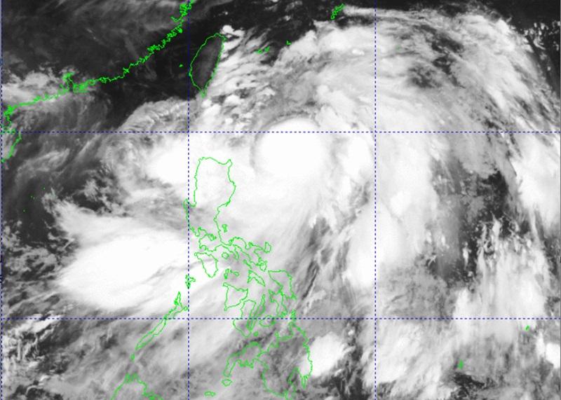
Typhoon Carina (international name: Gaemi) maintained its strength on Tuesday while moving north northwestward as 10 areas were placed under Signal No. 1, according to the 5 a.m. Tropical Cyclone Bulletin posted by PAGASA.
As of 3 a.m., the center of Typhoon Carina was estimated at 380 kilometers east of Aparri, Cagayan with maximum sustained winds of 130 kilometers per hour near the center and gustiness of up to 160 kph. It was moving north northwestward at 10 kph.
Tropical Cyclone Wind Signal (TCWS) No. 1 was hoisted over the following areas:
- Batanes
- Babuyan Islands
- the northern and eastern portions of mainland Cagayan (Santa Ana, Gattaran, Baggao, Peñablanca, Lal-Lo, Gonzaga, Buguey, Santa Teresita, Aparri, Camalaniugan, Ballesteros, Allacapan, Abulug, Pamplona, Claveria, Sanchez-Mira, Santa Praxedes, Lasam, Alcala)
- the eastern portion of Isabela (Divilacan, Palanan, Maconacon, Dinapigue, Tumauini, Ilagan City, San Mariano, Cabagan, San Pablo, Santa Maria)
- the northern portion of Apayao (Calanasan, Luna, Pudtol, Flora, Santa Marcela)
- the northern portion of Ilocos Norte (Pagudpud, Bangui, Adams, Dumalneg, Burgos, Vintar)
- the northern portion of Aurora (Dilasag, Casiguran)
- Polillo Islands
- Calaguas Islands
- the northern portion of Catanduanes (Pandan, Bagamanoc, Panganiban, Viga, Gigmoto, Caramoran)
Heavy rainfall (100-200mm) may be expected over Batanes and Babuyan Islands on Tuesday.
"Forecast rainfall are generally higher in elevated or mountainous areas. Under these conditions, flooding and rain-induced landslides are possible especially in areas that are highly or very highly susceptible to these hazards as identified in official hazard maps and in localities that experienced considerable amounts of rainfall for the past several days," PAGASA also reported.
The Southwest Monsoon enhanced by Carina will bring moderate to intense rainfall over various localities in the western portion of Luzon on Tuesday through Thursday.
The monsoon will also bring cloudy skies and rain showers over the rest of the country.
Ilocos Region, Abra, Benguet, Zambales, Bataan, Cavite, Batangas, Occidental Mindoro, and Northern Palawan including Calamian and Cuyo islands will have monsoon rains due to the Southwest Monsoon with possible flooding or landslides due to scattered to widespread rains.
Metro Manila, Oriental Mindoro, Romblon, Rizal, Laguna, Pampanga, Tarlac, Nueva Ecija, Bulacan, Aklan, Antique, and the rest of Codillera Administrative Region will have occasional rains due to the Southwest Monsoon with flash floods or landslides possibly occurring due to moderate to heavy rains.
Bicol Region, Negros Island Region, Zamboanga Peninsula, Quezon, Northern Samar, Basilan, Sulu, Tawi-Tawi, the rest of MIMAROPA, and the rest of Western Visayas will have cloudy skies with scattered rains and thunderstorms due to the Southwest Monsoon with flash floods or landslides occurring due to moderate to at times heavy rains.
The rest of the country will have partly cloudy to cloudy skies with isolated rain showers or thunderstorms due to the Southwest Monsoon with flash floods or landslides possibly occurring during severe thunderstorms.
The Southwest Monsoon enhanced by Carina will also bring strong to gale-force gusts over the following areas: Ilocos Region, Abra, Benguet, Nueva Vizcaya, Quirino, Zambales, Bataan, Aurora, Metro Manila, CALABARZON, MIMAROPA, Bicol Region, Visayas, Zamboanga Peninsula, Northern Mindanao, and Davao Region.
A gale warning was raised over the coastal waters of Batanes and Babuyan Islands. Sea travel is risky for small seacraft, including all types of motor bancas.
In the next 24 hours, Carina and the enhanced Southwest Monsoon will bring moderate to rough seas over the northern and eastern seaboards of Northern Luzon outside areas with gale warning, the eastern seaboards of Central and Southern Luzon, and western seaboards of Central and Southern Luzon.
Small seacraft, including all types of motor bancas, are advised to avoid venturing out to sea under these conditions, especially if inexperienced or operating ill-equipped vessels.
Moderate seas are also expected over the southern seaboards of Southern Luzon, the western and eastern seaboards of Visayas, and the eastern seaboard of Mindanao and mariners of motor bancas and similarly-sized vessels are advised to take precautionary measures.
Carina will remain far from the Philippine landmass and make landfall over the northern portion of Taiwan between Wednesday evening and Thursday morning, then exit the Philippine Area of Responsibility (PAR) hours later.
Sunrise will be at 5:37 a.m., sunset at 6:28 p.m.
Some local government units have canceled classes for Tuesday, July 23, due to the inclement weather caused by the enhanced Southwest Monsoon (Habagat). — BAP/KG, GMA Integrated News
