

More areas under Signal no. 1 as Typhoon Carina intensifies
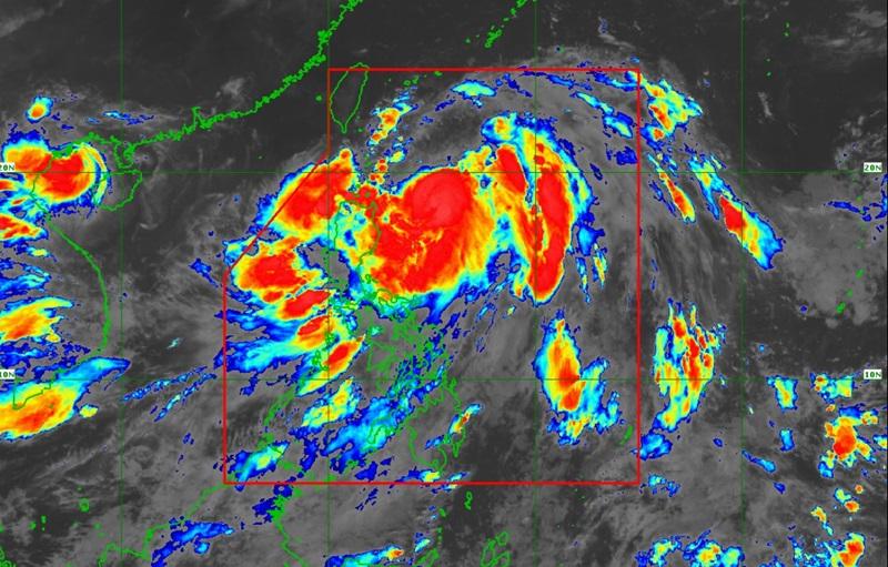
Typhoon Carina continues to intensify as it moves northwestward at 15 kph over the Philippine Sea, according to PAGASA’s 11 p.m. Tropical Cyclone Bulletin.
Carina was last seen 375 kilometers east northeast of Tuguegarao City, Cagayan with maximum sustained winds of 130 kilometers per hour, gustiness of up to kph and central pressure of 975 hPa.
The typhoon is currently moving northwestward at the speed of 15 km/h and with strong to typhoon-force winds extend outwards up to 560 km from the center.
Signal number 1 has now been raised over the following areas:
- Batanes
- Babuyan Islands
- The northern and eastern portions of mainland Cagayan (Santa Ana, Gattaran, Baggao, Peñablanca, Lal-Lo, Gonzaga, Buguey, Santa Teresita, Aparri, Camalaniugan, Ballesteros, Allacapan, Abulug, Pamplona, Claveria, Sanchez-Mira, Santa Praxedes, Lasam, Alcala)
- The eastern portion of Isabela (Divilacan, Palanan, Maconacon, Dinapigue, Tumauini, Ilagan City, San Mariano, Cabagan, San Pablo, Santa Maria)
- The northern portion of Apayao (Calanasan, Luna, Pudtol, Flora, Santa Marcela)
- The northern portion of Ilocos Norte (Pagudpud, Bangui, Adams, Dumalneg, Burgos, Vintar)
- The northern portion of Aurora (Dilasag, Casiguran)
- Polillo Islands
- Calaguas Islands
- The northern portion of Catanduanes (Pandan, Bagamanoc, Panganiban, Viga, Gigmoto, Caramoran)
These areas may experience winds of 39 to 61 kph or intermittent rains within 36 hours, very light or no damage to low risk structures, and light damage to medium to high risk structures.
PAGASA predicts heavy rainfall to affect the following areas on Monday night to Tuesday evening,
100 to 200mm in Batanes, Babuyan Islands; 50 to 100 mm in Ilocos Norte, Ilocos Sur, Abra, the northern and eastern portion of mainland Cagayan, and the eastern portion of Isabela.
"Forecast rainfall are generally higher in elevated or mountainous areas. Under these conditions, flooding and rain-induced landslides are possible especially in areas that are highly or very highly susceptible to these hazards as identified in official hazard maps and in localities that experienced considerable amounts of rainfall for the past several days," the weather bureau reported.
The Southwest Monsoon enhanced by Carina is forecast to bring moderate to intense rainfall over the western portion of Luzon from Monday evening until Thursday.
Severe Winds
It will also bring strong to gale-force gusts in the following areas on Monday night to Tuesday: Ilocos Region, Abra, Benguet, Nueva Vizcaya, Quirino, Zambales, Bataan, Aurora, Metro Manila, CALABARZON, MIMAROPA, Bicol Region, Visayas, Zamboanga Peninsula, Northern Mindanao, and Davao Region.
Hazarads affecting coastal waters
PAGASA reported that moderate seas are also expected over the eastern seaboards of Visayas and Mindanao, so mariners of motorbancas and similarly-sized vessels are advised to take precautionary measures while venturing out to sea and, if possible, avoid navigating under these conditions.
Typhoon Carina may reach its peak intensity as it steadily intensifies over the next two days.
However, the typhoon is predicted to remain far from Philippine landmass and exit the Philippine Area of Responsibility after landfall over the northern portion of Taiwan between Wednesday evening or Thursday morning. — Jiselle Anne Casucian/BAP, GMA Integrated News
