

Carina intensifies into typhoon; Signal no. 1 over three areas
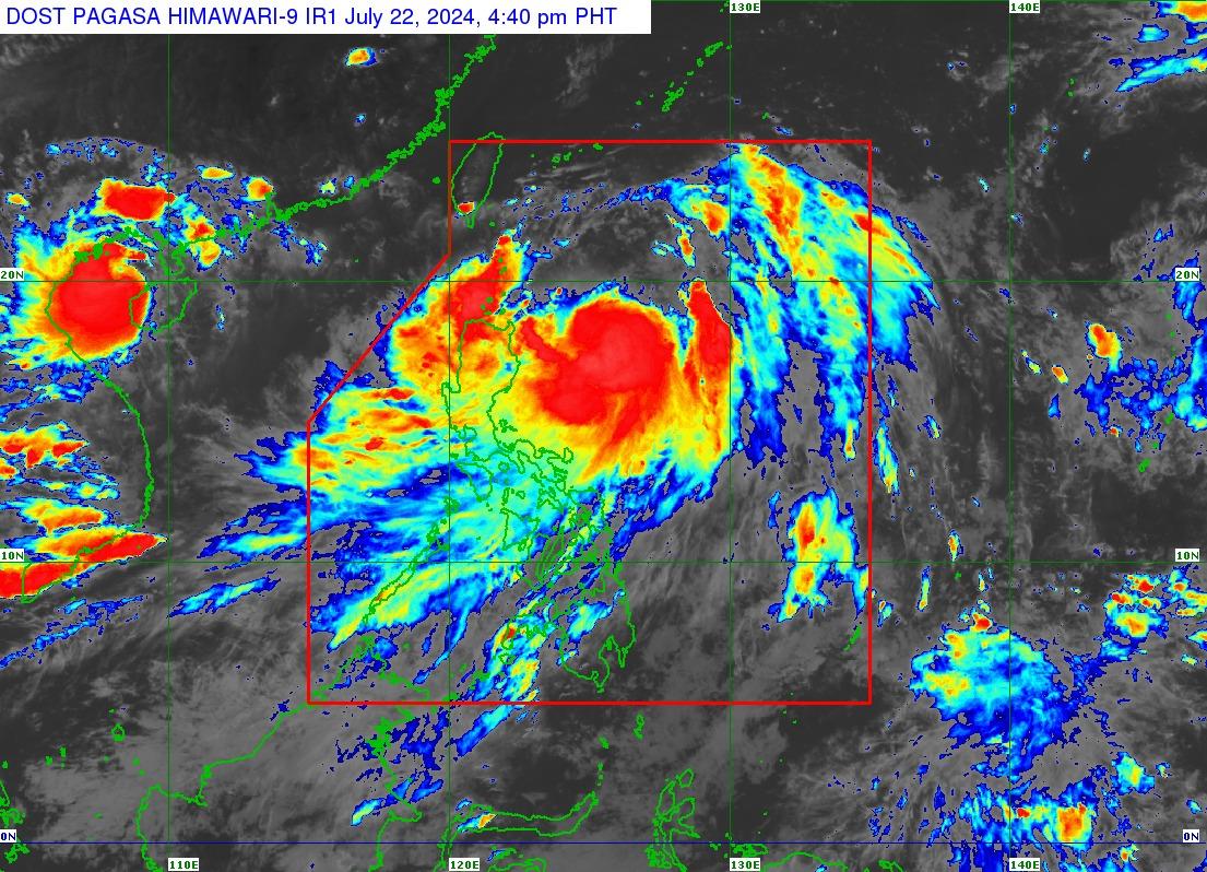
Severe Tropical Storm Carina has intensified into a typhoon with maximum sustained winds of 120 kph and gustiness of up to 150 kph at 420 kilometers east of Tuguegarao City, Cagayan, PAGASA said.
According to the state weather bureau's 5 p.m. cyclone bulletin, Storm Signal No. 1 remains hoisted over the following areas:
- Batanes,
- the eastern portion of mainland Cagayan (Santa Ana, Gattaran, Baggao, Peñablanca, Lal-Lo, Gonzaga) including the eastern portion of Babuyan Islands (Camiguin Is., Babuyan Is.), and
- the northeastern portion of Isabela (Divilacan, Palanan, Maconacon).
These areas may experience winds of 39 to 61 kph or intermittent rains within 36 hours, very light or no damage to low risk structures, and light damage to medium to high risk structures.
From Monday to Tuesday afternoon, Carina is forecast to bring 100 to 200 mm of rain to the extreme northeastern portion of mainland Cagayan and 50 to 100 mm of rain to the Babuyan Islands and the eastern portions of mainland Cagayan and Isabela.
As a result of the typhoon also enhancing the Southwest Monsoon or Habagat, parts of western portion of Luzon may see moderate to intense rainfall.
Both may also bring moderate to rough seas over the northern and eastern seaboards of Luzon and western seaboards of Central and Southern Luzon, and Western Visayas, and moderate seas over the eastern seaboards of Visayas and Mindanao.
Carina is expected to remain far from the Philippine landmass as it gradually accelerates north northwestward until Tuesday, and steadily intensifies over the next four days.
It is anticipated to exit the Philippine Area of Responsibility by Wednesday evening or Thursday early morning.
Habagat brings rain
Meanwhile, PAGASA’s 4 p.m. daily weather forecast on Monday afternoon showed that the majority of the country will be feeling the effects of the enhanced Southwest Monsoon.
Carina will cause cloudy skies with scattered rain showers and thunderstorms in Cagayan Valley and Aurora.
The Southwest Monsoon is forecast to bring monsoon rains over Ilocos Region, Abra, Benguet, Zambales, Bataan, Cavite, Batangas, and Occidental Mindoro, and occasional rains over Metro Manila, Oriental Mindoro, Romblon, Rizal, Laguna, Pampanga, Tarlac, Nueva Ecija, Bulacan, Aklan, Antique, and the rest of Cordillera Administrative Region, Northern Palawan including Calamian and Cuyo islands.
It may also bring cloudy skies with scattered rain showers and thunderstorms over Bicol Region, Negros Island Region, Zamboanga Peninsula, Quezon, Northern Samar, Basilan, Sulu, Tawi-Tawi, the rest of MIMAROPA, and the rest of Western Visayas, and partly cloudy to cloudy skies with isolated rain showers or thunderstorms over the rest of the country.
Possible flash floods and landslides may occur over some parts of the country as a result of said weather conditions.
The Philippines will experience moderate to strong winds with moderate to rough waters.
Sunrise in Metro Manila will be at 5:37 a.m. on Tuesday. — BM, GMA Integrated News
