

Signal No. 1 remains over Cagayan, Isabela as 'Carina' intensifies — PAGASA
Weather service PAGASA on Monday said Tropical Cyclone Wind Signal (TCWS) No. 1 remained over parts of northern Luzon as severe tropical storm Carina (international name: Gaemi) continued to steadily intensify as it moved northwestward over the Philippine Sea.
In its 11 a.m. bulletin, PAGASA said areas under Signal No. 1 are:
- Eastern portion of mainland Cagayan (Santa Ana, Gattaran, Baggao, Peñablanca, Lal-Lo, Gonzaga), including the eastern portion of Babuyan Islands (Camiguin Island, Babuyan Islands)
- Northeastern portion of Isabela (Divilacan, Palanan, Maconacon)
PAGASA warned that these areas would experience winds ranging from 39 kph to 61 kph in at least 36 hours or intermittent rains.
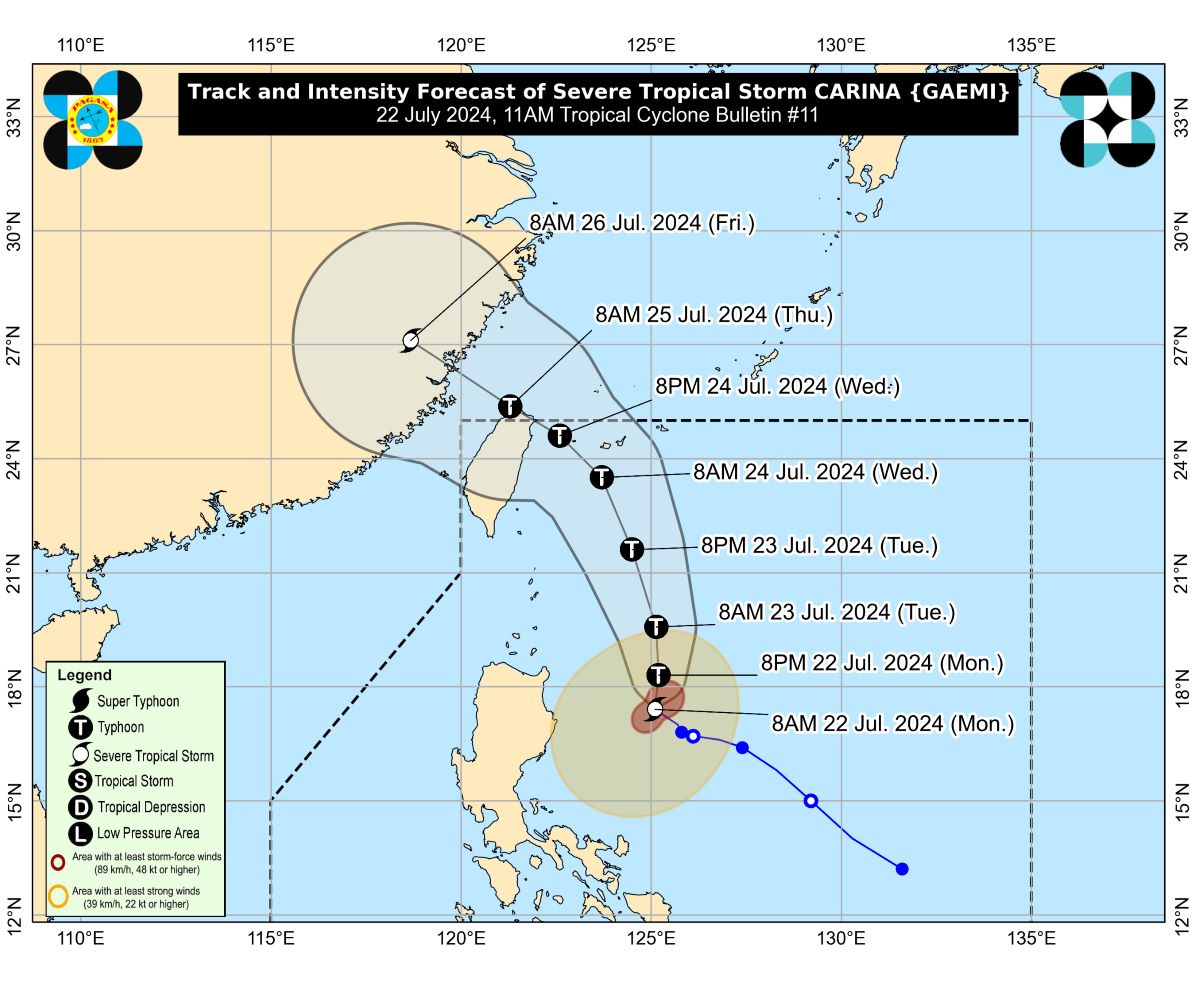
According to the weather bureau, the center of Carina's eye was estimated at 340 kms. east northeast of Casiguran, Aurora.
Carina was moving northwestward at 15 kph with maximum sustained winds of 110 kph near the center and gustiness of up to 135 kph.
Rainfall
Meanwhile, the weather bureau said the extreme northeastern portion of mainland Cagayan was forecast to have an estimated 100 to 200 mm of rainfall from Monday to Tuesday.
The Babuyan Islands and the eastern portions of mainland Cagayan and Isabela may also have 50 to 100 mm of rainfall.
From Tuesday noon to Wednesday noon, PAGASA said Batanes may get 100 to 200 mm of rainfall, while the Babuyan Islands and the northeastern portion of mainland Cagayan may get 50 to 100 mm of rainfall.
"Forecast rainfall are generally higher in elevated or mountainous areas. Under these conditions, flooding and rain-induced landslides are possible especially in areas that are highly or very highly susceptible to these hazards," it said.
Further, the southwest monsoon or Habagat enhanced by Carina may bring moderate to intense rainfall over several areas in the western portion of Luzon from Monday night through Wednesday.
According to PAGASA, the southwest monsoon will also bring strong to gale-force gusts over Zambales, Bataan, Aurora, MIMAROPA, Bicol region, Western Visayas, Northern Samar, and the northern portion of Samar on Monday.
Come Tuesday, it is forecast to bring such conditions in Ilocos Region, Zambales, Bataan, Aurora, Metro Manila, CALABARZON, MIMAROPA, Bicol Region, and Visayas.
Coastal waters
The weather bureau said that Carina and the southwest monsoon would bring moderate to rough seas over the northern and eastern seaboards of Luzon, the western seaboards of Central and Southern Luzon, and Western Visayas in the next 24 hours.
"Mariners of small seacrafts, including all types of motorbancas, are advised not to venture out to sea under these conditions, especially if inexperienced or operating ill-equipped vessels," PAGASA said.
Moderate seas are also expected over the seaboards of Viasyas and Mindanao.
PAGASA advised mariners of motorbancas and similar-sized vessels to take precautionary measures and, if possible, to avoid venturing out to sea in such conditions.
Moving northward
Carina was expected to move generally northward from Monday to Tuesday while gradually accelerating before turning northwestward.
PAGASA said would will remain far from the country's landmass and may exit the Philippine area of responsibility on Wednesday evening or Thursday early morning.
Carina was also forecast to intensify to a typhoon within 12 hours. — VDV, GMA Integrated News
