

Signal No. 1 up over parts of Cagayan, Isabela due to Carina
Tropical Cyclone Wind Signal (TCWS) No. 1 was raised over parts of Cagayan and Isabela on Monday due to the expected effects of Severe Tropical Storm Carina (international name: Gaemi), PAGASA said.
Areas under TCWS No. 1 are:
- the eastern portion of mainland Cagayan (Santa Ana, Gattaran, Baggao, Peñablanca, Lal-Lo, Gonzaga); and
- the northeastern portion of Isabela (Divilacan, Palanan, Maconacon).
These areas will experience strong winds ranging from 39 to 61 km/h within 36 hours, posting minimal to minor threat to life and property.
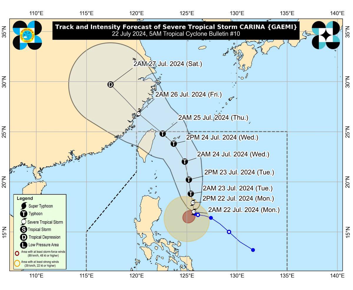
Carina became a severe tropical storm while remaining almost stationary over the Philippine Sea late Saturday night.
At 4 a.m. on Monday, Carina was still almost stationary and its center was estimated to be located at 420 km east of Tuguegarao City, Cagayan.
Carina was packing maximum sustained winds of 100 km/h near the center, gustiness of up to 125 km/h, and central pressure of 990 hPa.
The severe tropical storm was moving north northwestward slowly, with strong to storm-force winds extending outwards up to 360 km from the center.
Rainfall
The extreme northeastern portion of mainland Cagayan will have an estimated 100 to 200 mm amount of rainfall on Monday.
Babuyan Islands and the eastern portions of mainland Cagayan and Isabela meanwhile may have 50 to 100 mm of rainfall.
On Tuesday, Batanes is expected to receive 100 to 200 mm of rainfall while Babuyan Islands and the northeastern portion of mainland Cagayan may have 50 to 100 mm of rainfall.
On Wednesday, Batanes and Babuyan Islands may expect 50 to 100 mm of rainfall.
PAGASA said elevated or mountainous areas may have higher amounts of rainfall.
It also warned that flooding and rain-induced landslides may occur in areas highly or very highly susceptible to such hazards and in areas that had considerable amounts of rainfall in the past few days.
Habagat
Carina will also enhance the Southwest Monsoon (Habagat). The monsoon is forecast to bring moderate to intense rainfall over several areas in the western part of Luzon starting Monday night until Wednesday.
The Southwest Monsoon will also bring gale-force gusts over MIMAROPA, Bicol Region, Western Visayas, Northern Samar, and the northern portion of Samar on Monday, especially in coastal and upland areas exposed to winds.
Zambales, Bataan, Aurora, Metro Manila, CALABARZON, MIMAROPA, Bicol Region, and Visayas will experience gale-force gusts on Tuesday, while Ilocos Region, Abra, Benguet, Nueva Vizcaya, Quirino, Central Luzon, Metro Manila, CALABARZON, MIMAROPA, Bicol Region, and Visayas will do so on Wednesday.
Coastal waters
Moderate to rough seas are expected over the northern and eastern seaboards of Northern Luzon in the next 24 hours.
"Mariners of small seacrafts, including all types of motorbancas, are advised not to venture out to sea under these conditions, especially if inexperienced or operating ill-equipped vessels," PAGASA said.
The seaboards of Central and Southern Luzon and the eastern seaboards of Visayas and Mindanao meanwhile will have moderate seas. PAGASA also advised those with motor bancas and similarly-sized vessels to take precautionary measures, or avoid navigating if possible.
Track, intensity outlook
Carina is still over the Philippine Sea as of posting time and is expected to move generally north northwestward to northward until mid-Wednesday.
It will then gradually accelerate then turn northwestward.
"On the track forecast, CARINA will remain far from the Philippine landmass and exit the Philippine Area of Responsibility [PAR] on Wednesday evening or Thursday early morning (25 July)," PAGASA said.
Carina will pass near or over the Ryukyu archipelago in Japan before leaving PAR. It will then pass close to northern Taiwan after exiting PAR.
Carina is forecast to reach typhoon category within 24 hours.
PAGASA advised the public and disaster risk reduction and management offices concerned to take all necessary measures to protect life and property.
The weather bureau will issue the next bulletin at 11 a.m.
Classes
Due to the expected effects of Carina, classes in several areas on Monday have been canceled. —KG, GMA Integrated News
