

Carina intensifies over Philippine Sea, enhances Habagat
Tropical Storm Carina (international name: gaemi) on Sunday slightly intensified over the Philippine Sea on Sunday morning, and will continue to enhance the Southwest Monsoon or Habagat, according to PAGASA.
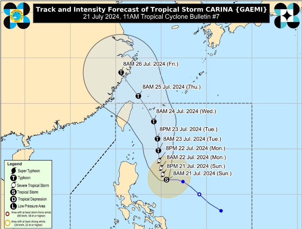
At 11 a.m. the center of Carina was estimated 350 kilometers east of Casiguran, Aurora, while moving westward at 20 kph.
Carina has a maximum sustained winds of 85 km/h near the center, gustiness of up to 115 kph, and central pressure of 996 hPa.
The storm has strong- to gale-force winds which extend outwards up to 320 km from the center.
No Tropical Cyclone Wind Signals (TCWS) are currently in effect as of posting time.
However, Wind Signal No. 1 may be raised over extreme Northern Luzon and the northeastern portion of mainland Cagayan, possibly by Sunday night or Monday.
PAGASA said the Habagat that will be enhanced by Carina and a tropical depression (formerly Butchoy) will bring strong to gale-force gusts over the following areas:
- Sunday to Monday noon: Mimaropa, Bicol Region, and Western Visayas
- From Monday noon to Tuesday noon: Zambales, Bataan, Metro Manila, Calabarzon, Mimaropa, Bicol Region, and Visayas
- From Tuesday noon to Wednesday noon: Ilocos Region, Central Luzon, Metro Manila, Calabarzon, Mimaropa, Bicol Region, and Visayas.
Mainland Cagayan and Babuyan Islands are expected to have 50-100 mm accumulated rainfall from Sunday to Monday afternoon.
The enhanced Habagat will also bring moderate to intense rainfall over various localities in the western portion of Luzon on Monday until Tuesday.
In the next 24 hours, Carina and the enhanced Habagat will also bring moderate seas over the coastal waters along the northern seaboard of Northern Luzon (1.0-2.5 m), the western seaboards of Central and Southern Luzon (1.5-2.5 m), and the eastern seaboard of the country (1.0-2.5 m).
Track, intensity
According to PAGASA, Carina may become a severe tropical storm by Sunday night and reach typhoon category on Monday evening.
"The tropical storm is forecast to steadily intensify over the next four days due to favorable environment. Rapid intensification within the forecast period is also possible.",PAGASA said.
Over the Philippine Sea, Carina is seen to move generally north northwestward to northward from Sunday until Tuesday.
Carina will also remain far from the Philippine landmass and exit the Philippine Area of Responsibility on Wednesday night (July 24) or Thursday early morning (July 25) while moving near the islands in the Ryukyu archipelago. —Giselle Ombay/RF, GMA Integrated News
