

Carina intensifies while over Philippine Sea, will enhance Habagat
Tropical Storm Carina (international name: Gaemi) on Sunday slightly intensified while over the Philippine Sea, and will enhance the Southwest Monsoon (Habagat), PAGASA said.
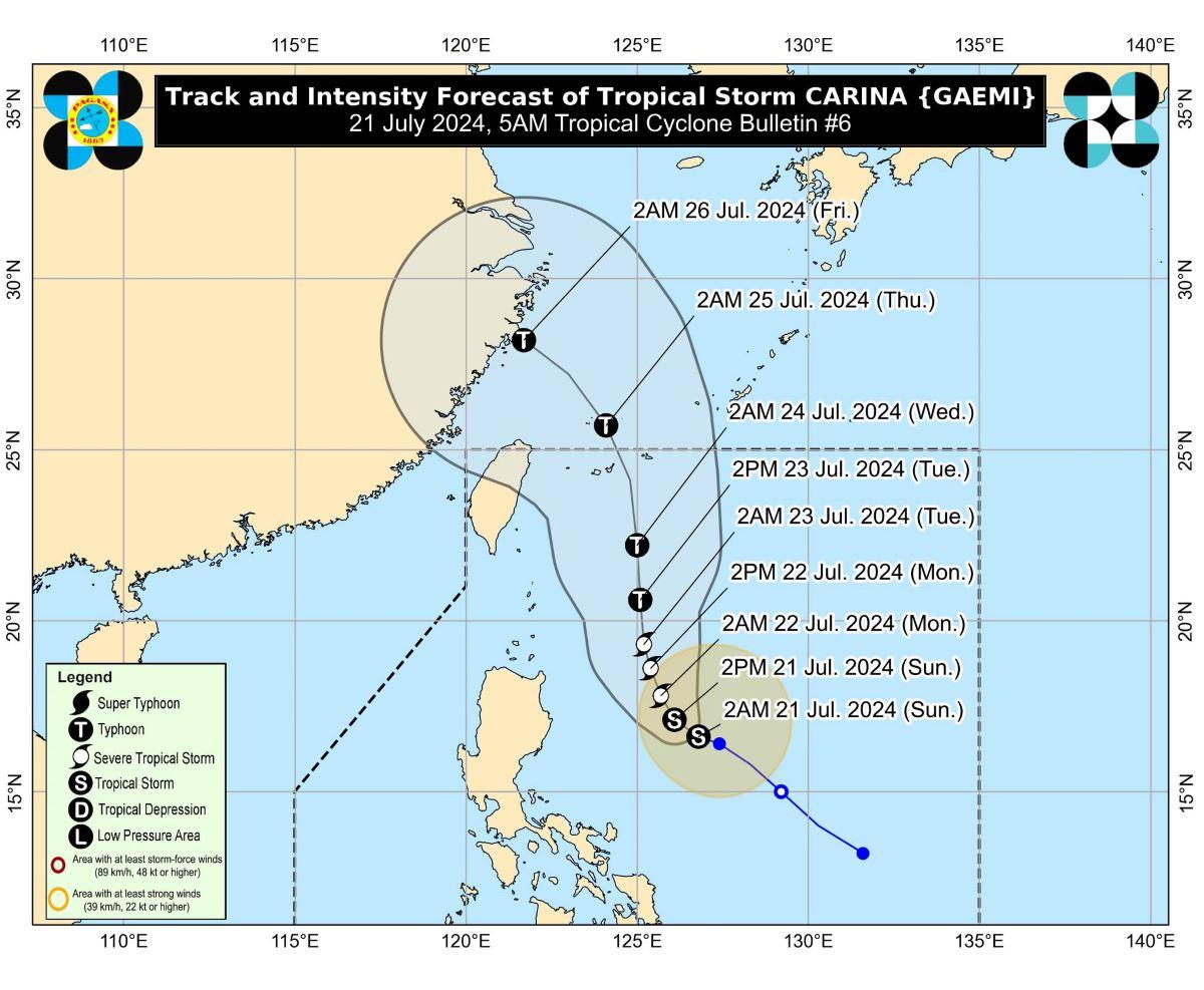
At 4 a.m., the center of Carina was estimated to be located at 490 km east of Casiguran, Aurora.
Carina has maximum sustained winds of 75 km/h near the center, gustiness of up to 90 km/h, and central pressure of 998 hPa.
The storm is moving west northwestward at 10 km/h.
From Carina's center, strong to gale-force winds are extending outwards up to 320 km.
No Tropical Cyclone Wind Signals (TCWS) were raised at this time by PAGASA. However, TCWS No. 1 may be hoisted over Extreme Northern Luzon and the northeastern portion of mainland Cagayan on Sunday night or Monday in anticipation of Carina's strong winds.
The northeastern portion of mainland Cagayan and the eastern portion of Babuyan Islands may expect 50-100 mm of rainfall on Monday.
On Tuesday, rainfall over Batanes is forecast to reach 100 to 200 mm, while that of Babuyan Islands may amount to 50 to 100 mm.
The amount of rainfall is generally higher in elevated or mountainous areas.
"Under these conditions, flooding and rain-induced landslides are possible especially in areas that are highly or very highly susceptible to these hazards as identified in official hazard maps and in localities that experienced considerable amounts of rainfall for the past several days," PAGASA said.
On Monday and Tuesday, the enhanced Southwest Monsoon will also bring moderate to intense rainfall over parts of western Luzon.
Strong to gale-force gusts of wind are to be expected in Kalayaan Islands on Sunday due to the Southwest Monsoon enhanced by Carina and the tropical depression formerly known as Butchoy when it was still inside the Philippine Area of Responsibility (PAR).
Zambales, Bataan, Metro Manila, CALABARZON, MIMAROPA, Bicol Region, Western Visayas will also have strong to gale-force gusts on Monday due to the monsoon.
Ilocos Region, Zambales, Bataan, Aurora, Metro Manila, CALABARZON, MIMAROPA, Bicol Region, and Western Visayas on the other hand will be affected by strong to gale-force gusts on Tuesday due to the Habagat.
Coastal waters will be moderate along the northern seaboard of Northern Luzon (1.0-2.5 m), the western seaboards of Central and Southern Luzon (1.0-2.5 m), and the eastern seaboard of the country (1.0-2.5 m) in the next 24 hours due to Carina and the monsoon.
"Mariners of motorbancas and similarly-sized vessels are advised to take precautionary measures while venturing out to sea and, if possible, avoid navigation under these conditions," PAGASA said.
"Over the Philippine Sea, CARINA is forecast to move generally northwestward today and tomorrow (22 July), then northward on Tuesday (23 July)," the weather bureau added.
Carina is expected to remain far from the Philippine landmass then exit PAR on Wednesday as it moves near the Ryukyu archipelago in Japan.
"Outside the PAR, CARINA will turn generally northwestward on Thursday (25 July) over the East China Sea, passing near or over Senkaku Islands," PAGASA said.
In the next four days, Carina is expecgted to steadily intensify and become a severe tropical storm on Monday. It is expected to reach typhoon category on Tuesday.
PAGASA advised the public and disaster risk reduction and management offices concerned to take the necessary measures to protect life and property.
The weather bureau will issue the next bulletin at 11 a.m. Sunday. —KG, GMA Integrated News
