

Philippines sandwiched between 2 tropical depressions in PAR
The low pressure areas to the west and east of the archipelago have strengthened into tropical depressions which the weather bureau PAGASA named Butchoy and Carina.
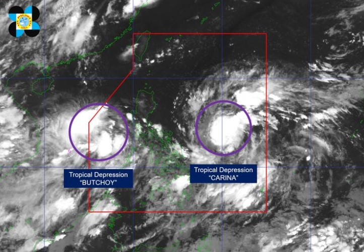
Butchoy was the LPA west of Batangas while Carina was the one to the east of Eastern Visayas. PAGASA said they developed into tropical depressions around 8 p.m.
According to PAGASA’s 11 p.m. tropical cyclone bulletin, the eye of tropical depression Butchoy was located 535 kilometers west of Tanauan City, Batangas.
Carina's center was estimated 780 kilometers east of Virac, Catanduanes
Butchoy moved westward at 25 kph with maximum sustained winds of 55 kph and gustiness of up to 70 kph.
Carina had maximum sustained winds of 45 kph near the center, gustiness of up to 55 kph, and was moving west northwestward at 20 kph.
Heavy rainfall directly caused by Carina remains less likely over next three days but there may be changes in the current forecast scenario in the next bulletins.
The Southwest Monsoon currently enhanced by Butchoy will also be enhanced by Carina starting on Sunday, resulting in moderate to heavy rains over the western portion of Luzon over the next three days.
PAGASA said Butchoy is unlikely to directly affect the country within the next three days, but may enhance the Southwest Monsoon and bring “moderate to heavy rains over the western portion of Luzon” within the next three days.
The combined effects Butchoy and the Southwest Monsoon may cause moderate to rough seas over the northern and western seaboards of Luzon.
Butchoy is anticipated to exit the PAR within the next 12 hours and experience a limited intensification within the next two days before making a landfall in China by Monday.
PAGASA advised the public regarding hazards posed by the enhanced Southwest Monsoon over the next three days.
According to PAGASA’s weather advisory at 11 p.m. on Friday, the Southwest Monsoon may bring moderate to heavy rains over Northern Palawan and Occidental Mindoro on Saturday.
Zambales, Bataan, Occidental Mindoro, and Northern Palawan will also experience moderate to heavy rains on Sunday, while Ilocos Region, Zambales, Bataan, Northern Palawan, and Occidental Mindoro may also experience moderate to heavy rains on Monday.
“Under these conditions, flooding and rain-induced landslides remain possible, especially in areas that are highly or very highly susceptible to these hazards as identified in hazard maps and areas with significant antecedent rainfall,” the advisory read.
The state weather bureau advised local public and disaster risk reduction and management offices to prepare necessary precautions against possible hazards resulting from said weather conditions. —NB, GMA Integrated News
