
20 areas under Signal No. 1; Aghon now over Northern Samar waters
Twenty areas in Luzon and Visayas were placed under Tropical Cyclone Wind Signal (TCWS) No. 1 as Tropical Depression Aghon maintained its strength while traversing the coastal waters of San Vicente, Northern Samar, PAGASA said Saturday.
In its 11 a.m. bulletin, PAGASA said the following areas were under TCWS No. 1:
- the eastern portion of Bulacan (Norzagaray, Doña Remedios Trinidad, City of San Jose del Monte);
- the eastern portion of Nueva Ecija (General Tinio, Gabaldon);
- Aurora;
- the northern and southeastern portion of Quezon (Calauag, Guinayangan, Lopez, Buenavista, Catanauan, Mulanay, San Narciso, San Francisco, San Andres, Tagkawayan, Gumaca, Quezon, Alabat, Perez, Plaridel, Pitogo, Macalelon, General Luna, Atimonan, Unisan, Mauban, Real, Infanta, General Nakar, Padre Burgos, Agdangan, Sampaloc, Lucban, City of Tayabas, Pagbilao, Lucena City) including Pollilo Islands;
- the eastern portion of Laguna (Majayjay, Magdalena, Pagsanjan, Santa Cruz, Luisiana, Cavinti, Lumban, Kalayaan, Paete, Pangil, Siniloan, Mabitac, Santa Maria, Famy, Pakil);
- the eastern portion of Rizal (City of Antipolo, Rodriguez, Tanay, Baras, Jala-Jala, Pililla, Morong, Teresa, San Mateo);
- the eastern portion of Romblon (Cajidiocan, Magdiwang, San Fernando, Romblon, Corcuera, Banton);
- Marinduque;
- Sorsogon;
- Albay;
- Catanduanes;
- Camarines Sur;
- Camarines Norte;
- Masbate including Ticao and Burias Islands;
- Northern Samar;
- Samar;
- Eastern Samar (Can-Avid, Maslog, City of Borongan, San Policarpo, Taft, Llorente, Maydolong, Dolores, Jipapad, Oras, Arteche, Balangkayan, Sulat, San Julian, Lawaan, Balangiga, General Macarthur, Giporlos, Quinapondan, Hernani);
- Biliran;
- the northern portion of Leyte (Tunga, Pastrana, San Miguel, Matag-Ob, Tolosa, Palo, Calubian, Leyte, Carigara, Babatngon, Dagami, Jaro, San Isidro, Santa Fe, Villaba, Palompon, Tabontabon, Tanauan, Merida, Ormoc City, Isabel, Capoocan, Alangalang, Tabango, Tacloban City, Kananga, Barugo); and
- the extreme northern portion of Cebu (San Remigio, Tabogon, City of Bogo, Medellin, Daanbantayan, Borbon) including Bantayan Islands.
Under TCWS No. 1, minimal to minor impacts from strong winds are possible, according to PAGASA.
The highest possible TCWS that could be hoisted during Aghon’s passage is Signal No. 2, the state weather bureau said.
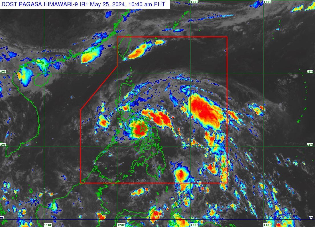
Location of eye/center
The center of Tropical Depression Aghon was estimated based on all available data over the coastal waters of San Vicente, Northern Samar (12.3 °N, 124.0 °E).
It is moving northwestward at 30 km/h, with maximum sustained winds of 55 km/h near the center and gustiness of up to 85 km/h.
Coastal waters
PAGASA said Aghon is expected to bring moderate to rough seas (1.5 to 3.5 m) over the coastal waters along the seaboards of Bicol Region, the southern seaboard of Quezon, the eastern seaboard of Eastern Visayas, the western seaboard of Samar and Northern Samar, and the eastern seaboard of Caraga Region.
Mariners of motor bancas and similarly-sized vessels are thus advised to take precautionary measures while venturing out to sea and avoid navigating, if possible, especially if inexperienced or operating ill-equipped vessels.
Track and intensity outlook
PAGASA said Aghon is forecast to move generally northwestward and may possibly make landfall over Ticao Island within the next 12 hours. The tropical depression already made landfall in the vicinity of Giporlos in Eastern Samar early Saturday morning
Aghon will then continue to move northwestward over the coastal waters of Burias Island between Saturday afternoon or evening.
Aghon is forecast to emerge either over Lamon Bay or the waters north of Camarines Provinces by Sunday early morning, which may be followed by another landfall in the vicinity of Polillo Islands. During the said period, Aghon may reach tropical storm category.
As Aghon recurves towards the northeast around Sunday afternoon or evening, and moves over the Philippine Sea, it is forecast to continuously intensify and may reach typhoon category on Tuesday evening or Wednesday morning.
Based on the track forecast, Aghon may exit the Philippine Area of Responsibility no earlier than Tuesday.
Preparations, effects
The National Disaster Risk Reduction and Management Council and the Office of Civil Defense said on Friday that the "high-risk" Emergency Preparedness and Response (EPR) protocol was activated in four regions due to Aghon.
OCD spokesperson Director Edgar Posadas explained that a Pre-Disaster Risk Assessment (PDRA) had been made, and the high-risk "Charlie" EPR protocol was raised for the emergency response organizations in:
- National Capital Region
- Cordillera Autonomous Region
- Bicol Region, and
- Eastern Visayas Region.
The Charlie or high-risk protocol includes activating emergency operations centers to red alert, recommending class and work suspension, imposing preemptive and forced evacuations, among others.
Aghon brought rains over several areas overnight in Eastern Samar and authorities reported some passengers were stranded and power went out in some places.
Around 600 individuals and some rolling cargoes were stranded in ports in Eastern Visayas.
Sea travel going into Region 8 was stopped on Friday night.
Some municipalities in Southern Leyte, Eastern Samar, and Western Samar have already implemented preventive evacuation of residents in flood-prone and landslide-prone areas
Meanwhile, the centermost area of Eastern Samar experienced power outage.
Some flights for Saturday, May 25, were canceled due to bad weather, the Manila International Airport Authority said. —KG, GMA Integrated News
