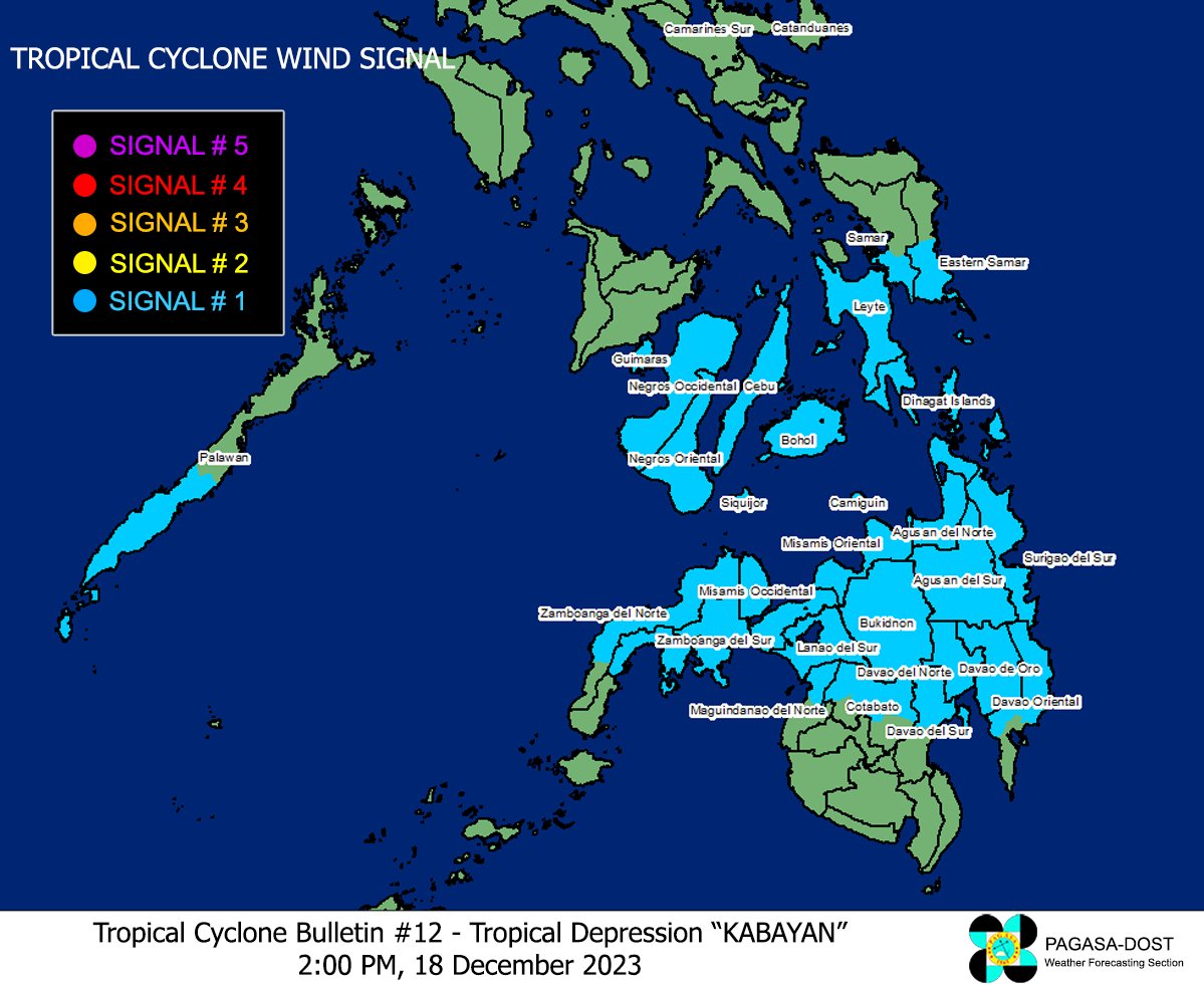
Signal No. 1 up in over 30 areas as Kabayan slightly weakens

At least 30 areas remain under Tropical Cyclone Wind Signal (TCWS) No. 1 as Tropical Depression Kabayan further weakened on Monday afternoon, state weather bureau PAGASA said.
In its 2 p.m. bulletin, PAGASA said the following areas are under TCWS No. 1:
- the southern portion of Palawan (Sofronio Española, Brooke's Point, Bataraza, Balabac, Rizal, Quezon, Narra), including Cagayancillo Islands
- Southern Leyte
- Leyte
- the southern portion of Samar (Basey, Santa Rita, Marabut, Talalora, Villareal, Pinabacdao)
- the southern portion of Eastern Samar (Maydolong, City of Borongan, Quinapondan, Guiuan, Lawaan, Balangiga, Llorente, Giporlos, Salcedo, Balangkayan, General Macarthur, Hernani, Mercedes)
- Cebu, including Camotes Islands
- Bantayan Islands
- Bohol
- Siquijor
- Negros Oriental
- Negros Occidental
- Guimaras
- Misamis Oriental
- Camiguin
- Bukidnon
- Davao de Oro
- the northern portion of Davao Oriental (Baganga, Manay, Caraga, Tarragona, Lupon, Banaybanay, Boston, Cateel)
- Misamis Occidental
- Lanao del Norte
- Lanao del Sur
- Davao del Norte
- Davao City
- the northern portion of Cotabato (Arakan, Carmen, Banisilan, Alamada, President Roxas, Kabacan, Matalam, Antipas, Magpet, Libungan, Pigkawayan)
- the northern portion of Maguindanao (Buldon, Barira, Matanog, Parang, Sultan Kudarat, Sultan Mastura)
- the western and central portion of Zamboanga del Norte (Siayan, Sindangan, Jose Dalman, Manukan, Pres. Manuel A. Roxas, Sergio Osmeña Sr., Katipunan, Dipolog City, Polanco, Mutia, Piñan, Dapitan City, Sibutad, La Libertad, Rizal, Siocon, Baliguian, Gutalac, Labason, Kalawit, Tampilisan, Liloy, Salug, Godod, Bacungan)
- the western and central portion of Zamboanga del Sur (Midsalip, Labangan, Tukuran, Aurora, Sominot, Ramon Magsaysay, Tambulig, Dumingag, Mahayag, Josefina, Molave, Vincenzo A. Sagun, Guipos, Dimataling, Dumalinao, Lakewood, Dinas, San Pablo, Tigbao, Tabina, Kumalarang, Lapuyan, Pitogo, Margosatubig, San Miguel, Bayog, Pagadian City)
- Zamboanga Sibugay
- Dinagat Islands
- Surigao del Norte
- Agusan del Norte
- Surigao del Sur
- Agusan del Sur
At 1 p.m., PAGASA said Kabayan was located in the vicinity of Loreto, Agusan del Sur with maximum sustained winds of 45 kilometers per hour, gustiness of up to 75 km/h, and central pressure of 1004 hPa.
The strong to gale-force winds of Kabayan, which was moving west northwestward at 20 km/h, extend up to 420 km from the center.
Kabayan is expected to move westward or west northwestward across the Philippine archipelago over the next two days, PAGASA said.
The tropical depression will keep on crossing the rugged terrain of Mindanao and emerge over the Sulu Sea between Monday afternoon and evening.
“Due to frictional effects associated with landfall, Kabayan is forecast to further weaken, and the possibility of being downgraded into a low pressure area while over land or after emerging over the sea is not ruled out (although in such a case, re-development may still occur over the Sulu Sea),” PAGASA said.
Kabayan is likely to make another landfall over central or southern Palawan as a tropical depression by Tuesday morning or afternoon and pass near or over Kalayaan Islands between Tuesday evening and Wednesday morning, according to PAGASA.—Joviland Rita/AOL, GMA Integrated News


