6 areas under Signal No. 2 as Kabayan approaches Davao Oriental

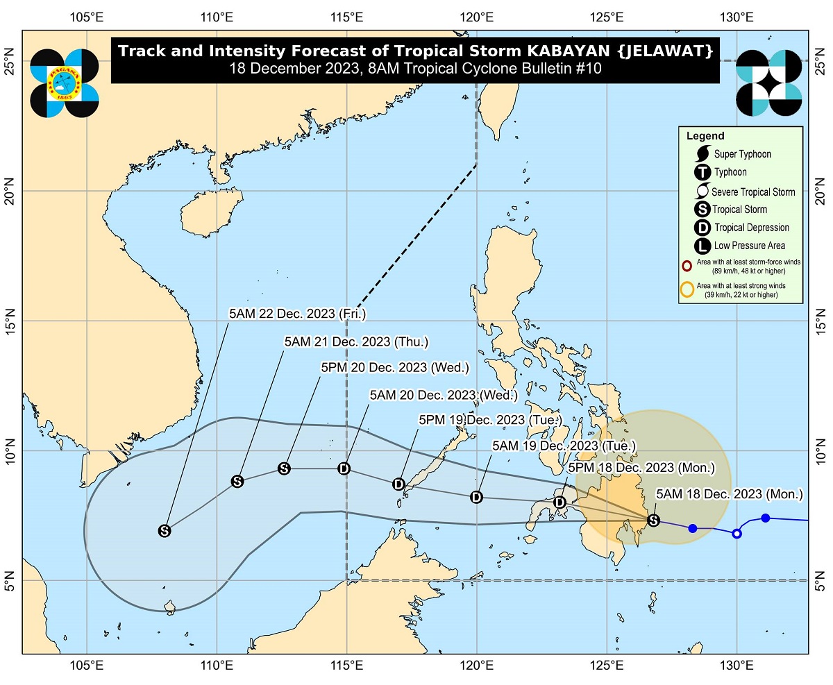
Tropical Cyclone Wind Signal (TCWS) No. 2 is hoisted over six areas as Tropical Storm Kabayan shifted southward and may make a landfall along the coast of Davao Oriental on Monday morning.
In its 8 a.m. bulletin, PAGASA said TCWS No. 2 is raised over the following areas:
- Dinagat Islands
- Surigao del Norte including Siargao and Bucas Grande Islands
- Surigao del Sur
- the northern portion of Agusan del Norte (Kitcharao, Jabonga, Santiago, City of Cabadbaran, Remedios T. Romualdez, Tubay)
- the eastern portion of Agusan del Sur (Trento, Bunawan, San Francisco, Rosario, Prosperidad, City of Bayugan, Sibagat)
- the northern portion of Davao Oriental (Boston, Cateel)
Meanwhile, TCWS No. 1 is up over the following areas:
- The southern portion of mainland Palawan (Sofronio Española, Brooke's Point, Bataraza, Balabac, Rizal, Quezon, Narra)
- Cagayancillo Islands
- Southern Leyte
- Leyte
- the southern portion of Samar (Basey, Santa Rita, Marabut, Talalora, Villareal, Pinabacdao)
- the southern portion of Eastern Samar (Maydolong, City of Borongan, Quinapondan, Guiuan, Lawaan, Balangiga, Llorente, Giporlos, Salcedo, Balangkayan, General Macarthur, Hernani, Mercedes)
- Cebu including Camotes and Bantayan Islands
- Bohol
- Siquijor
- Negros Oriental
- Negros Occidental
- Guimaras
- the rest of Agusan del Norte
- the rest of Agusan del Sur
- the central portion of Davao Oriental (Baganga, Manay, Caraga, Tarragona, Lupon, Banaybanay)
- Davao de Oro
- Davao del Norte
- Davao City
- Camiguin
- Misamis Oriental
- Bukidnon
- Misamis Occidental
- Lanao del Norte
- Lanao del Sur
- the northern portion of Maguindanao del Norte (Buldon, Barira, Matanog, Parang, Sultan Kudarat, Sultan Mastura)
- the northern portion of Cotabato (Arakan, Carmen, Banisilan, Alamada, President Roxas, Kabacan, Matalam, Antipas, Magpet, Libungan, Pigkawayan),
- the northern and central portions of Zamboanga del Norte (Siayan, Sindangan, Jose Dalman, Manukan, Pres. Manuel A. Roxas, Sergio Osmeña Sr., Katipunan, Dipolog City, Polanco, Mutia, Piñan, Dapitan City, Sibutad, La Libertad, Rizal, Siocon, Baliguian, Gutalac, Labason, Kalawit, Tampilisan, Liloy, Salug, Godod, Bacungan)
- Zamboanga del Sur
- Zamboanga Sibugay
At 7 a.m., PAGASA said Kabayan was located over the coastal waters of Manay, Davao Oriental, packing maximum sustained winds of 65 kilometers per hour and gustiness of up to 80 km/h.
Kabayan, which was moving westward at 20 km/h, made a southward shift and is forecast to track generally westward or west northwestward path across the Philippine archipelago over the next two days, PAGASA said.
Kabayan is likely to make landfall as a tropical storm along the coast of Davao Oriental on Monday morning, it added.
The cyclone cross the rugged terrain of Mindanao and emerge over the Sulu Sea between Monday afternoon and evening. Due to this, PAGASA said it is possible that Kabayan would weaken into a tropical depression or low pressure area.
Kabayan is also seen to make another landfall over central or southern Palawan as a tropical depression by Tuesday morning or afternoon, and then pass near or over Kalayaan Islands between Tuesday evening and Wednesday morning, PAGASA said.
An accumulated rainfall of 100-200 millimeters is expected over Surigao del Sur, Surigao del Norte, Dinagat Islands, Agusan del Sur, Davao del Norte, Davao de Oro, and Davao Oriental, PAGASA said.
Meanwhile, an accumulated rainfall of 50-100 millimeters is possible over Central Visayas, Biliran, Leyte, Southern Leyte, Zamboanga del Norte, Northern Mindanao, Davao City, Cotabato, Lanao del Sur, the southern portions of Samar and Eastern Samar, and the rest of Caraga, Davao Oriental, Davao de Oro, and Davao del Norte.
Forecast rainfall is generally higher in elevated or mountainous areas, said PAGASA, which warned of flooding and rain-induced landslides in areas prone to these hazards and those with considerable amounts of rainfall for the past several days.
Heavy rainfall is also expected over the eastern portion of Southern Luzon due to the shear line coinciding with the passage of Kabayan.
Minor to moderate impacts from gale force winds may be experienced in areas under TCWS No. 2, while minimal to minor impacts from strong winds in areas under TCWS No. 1.
Due to the Northeast Monsoon surge and Kabayan, a Gale Warning is in effect for the coastal waters along the seaboard of Northern Luzon, the eastern and central seaboards of Visayas, and the eastern seaboards of Central Luzon, Southern Luzon, and Mindanao.
“Sea travel is risky for small seacraft (including all motor bancas of any type or tonnage). Mariners of these vessels are advised to remain in port or seek safe harbor,” PAGASA said.
Moderate to rough seas of up to 3.5 meters are also possible over the western seaboards of Central and Southern Luzon, the western and northern seaboards of Mindanao, and the remaining seaboard of Visayas.
“Mariners of motor bancas and similarly-sized vessels are advised to take precautionary measures while venturing out to sea and, if possible, avoid navigating in these conditions, especially if inexperienced or operating ill-equipped vessels,” PAGASA said. —Joviland Rita/KBK, GMA Integrated News


