

Tropical cyclone downgraded to LPA; shear line, Amihan to bring rains over parts of PH
The Tropical Depression monitored by the local weather bureau east southeast of Palau has weakened into a Low Pressure Area (LPA).
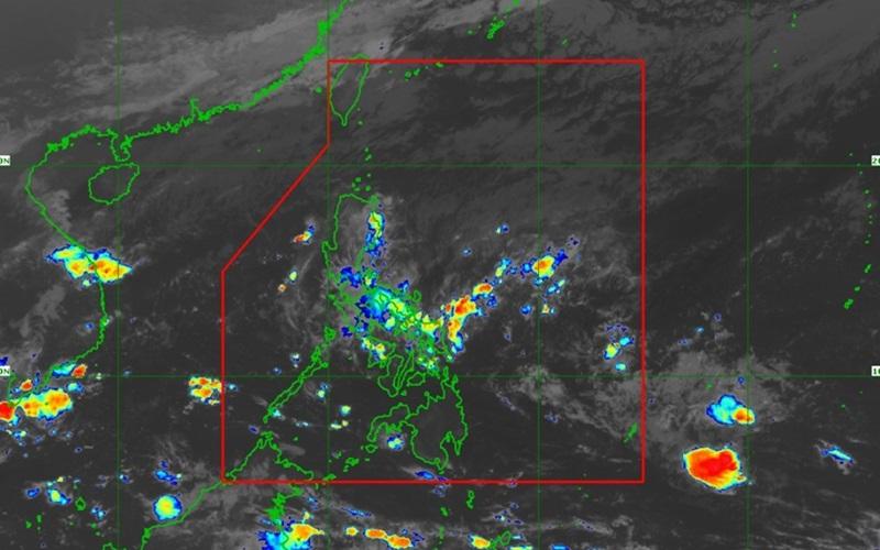
On Tuesday, PAGASA also reported that the shear line will be affecting Southern Luzon while the Northeast Monsoon (Amihan) will affect Northern and Central Luzon.
As of 4 a.m., the LPA was estimated at 1,620 kilometers east of Southeastern Mindanao outside the Philippine Area of Responsibility (PAR) with central pressure of 1006 hPa and moving south southwestward at a speed of 10 kilometers per hour.
The LPA is forecast to move erratically and may move near or around its present position in the next 24 hours as it remains highly disorganized.
"Should the disturbance re-develop within or enter the PAR as a tropical depression, the domestic name 'Kabayan' will be assigned to it. Within the PAR, this weather system will continue tracking westward until Friday while slowly intensifying. A more northwestward turn during the weekend over the waters east of Mindanao [may be expected]," PAGASA reported.
The interaction between the LPA and a possible shear line related to the forecast surge of the Amihan may result in heavy rainfall over the eastern portion of Mindanao starting Friday and over Bicol Region and most of Visayas (especially the eastern portion) on Saturday.
The Bicol Region, Quezon, Northern Samar, Eastern Samar, and Samar will have cloudy skies with scattered rain showers and thunderstorms due to the shear line with flash floods or landslides possibly occurring due to moderate to at times heavy rains.
Cagayan Valley, Ilocos Norte, and Apayao will have cloudy skies with rains due to the Northeast Monsoon. Flash floods or landslides may occur due to moderate to at times heavy rains.
Central Luzon, the rest of Ilocos Region, and the rest of the Cordillera Administrative Region will have partly cloudy to cloudy skies with isolated light rains also due to the Amihan but with no significant impact.
Metro Manila and the rest of the country will have partly cloudy to cloudy skies with isolated rain showers or thunderstorms due to the shear line and localized thunderstorms with possible flash floods or landslides occurring during severe thunderstorms.
Gale warnings for coastal waters are currently being issued due to risky sea conditions caused by the surge of the Amihan.
The wind speed forecast for Northern Luzon will be moderate to strong moving northeastward while coastal waters will be moderate to rough.
The rest of the country will experience light to moderate wind speed moving northeastward with slight to moderate coastal waters.
Sunrise will be at 5:56 a.m., sunset 5:24 p.m. — BAP/KG, GMA Integrated News
