

Jenny moves west northwestward, Signal No. 3 remains over Itbayat
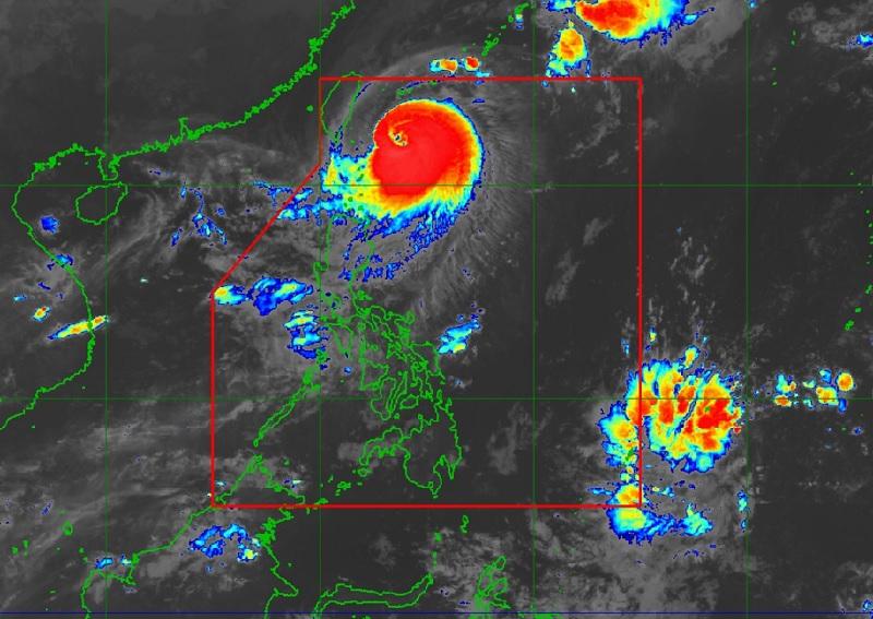
Typhoon Jenny slightly weakens and commences its west northwestward turn towards southern Taiwan as Signal No. 3 remains over Itbayat, Batanes, PAGASA reported.
According to the 5 a.m. Tropical Cyclone Bulletin, the center of the eye of Typhoon Jenny was estimated at 270 kilometers east northeast of Itbayat, Batanes, packing maximum sustained winds of 150 kilometers per hour near the center, gustiness of up to 185 km/h, and central pressure of 955 hPa.
Jenny is moving west northwestward at the speed of 10 km/h with strong to typhoon-force winds extending outwards up to 560 km from the center.
Tropical Cyclone Wind Signal (TCWS) No. 3 is hoisted over the north portion of Batanes (Itbayat).
TCWS Signal No. 2 is raised over the following areas:
- the rest of Batanes
- the northern portion of Babuyan Islands (Babuyan Island, Calayan Island)
TCWS Signal No. 1 is hoisted over the following areas:
- the rest of Babuyan Islands
- the northern portion of mainland Cagayan (Santa Ana, Gonzaga, Buguey, Santa Teresita, Lal-Lo, Camalaniugan, Pamplona, Claveria, Aparri, Ballesteros, Abulug, Allacapan, Sanchez-Mira, Santa Praxedes, Lasam, Gattaran)
- the northern portion of Apayao (Calanasan, Pudtol, Luna, Santa Marcela, Flora)
- the northern portion of Ilocos Norte (Piddig, Bangui, Vintar, Burgos, Pagudpud, Bacarra, Adams, Pasuquin, Carasi, Dumalneg, Laoag City)
Hazards affecting land areas
The forecast accumulated rainfall for today in Batanes is 100-200 mm and for the northern portion of the Babuyan Islands 50-100 mm.
Jenny will continue to enhance the Southwest Monsoon and bring occasional rains over the western portions of Luzon in the next 3 days.
Batanes and Babuyan Islands will be stormy due to Typhoon Jenny with flooding or landslides possibly occurring due to moderate to heavy rains. There may be minor to moderate threat to lives and properties due to strong winds.
Mainland Cagayan, Isabela, Apayao, Kalinga, Abra, and Ilocos Norte will have rains with gusty winds also due to the typhoon flooding or landslides possibly occurring due to moderate to heavy rains. PAGASA warned that minimal to minor threat to lives and properties due to strong winds.
The rest of Cagayan Valley, the rest of Cordillera Administrative Region, and the rest of Ilocos Region will have cloudy skies with scattered rain showers and thunderstorms due to the trough of Typhoon Jenny. Flash floods or landslides may occur in these areas due to moderate to at times heavy rains.
Zambales, Bataan, Occidental Mindoro, and the northern portion of Palawan will have occasional rains due to the southwest monsoon with flash floods or landslides possibly occurring due to moderate to heavy rains.
Metro Manila, CALABARZON, the rest of Central Luzon, and the rest of MIMAROPA will have cloudy skies with scattered rain showers and thunderstorms also due to the southwest monsoon with flash floods or landslides possibly occurring due to moderate to at times heavy rains.
The rest of the country will have partly cloudy to cloudy skies with isolated rain showers or thunderstorms due to the southwest monsoon and localized thunderstorms with the possibility that flash floods or landslides occurring during severe thunderstorms.
Severe Winds
The wind signals warn the public of the general wind threat over an area due to the tropical cyclone. Local winds may be slightly stronger/enhanced in coastal and upland/mountainous areas exposed to winds. Winds are less strong in areas sheltered from the prevailing wind direction.
The typhoon will enhance southwest monsoon bringing gusty conditions for the next 3 days over the following areas not under any Wind Signal, especially in coastal and upland/mountainous areas exposed to winds: The southern portion of Aurora, Bataan, Metro Manila, Occidental Mindoro, Kalayaan Islands, Romblon, most of CALABARZON, and portions of Bicol Region.
Hazards affecting coastal waters
A Gale Warning is in effect for the coastal waters along the seaboards of Northern Luzon.
Extreme Northern Luzon will experience strong wind speed moving in the northwest to west direction with rough coastal waters.
The rest of Luzon will experience moderate to strong wind speed moving in the west to southwest direction while coastal waters will be moderate to rough.
Visayas and Mindanao will experience light to moderate wind speed moving in the south to southwest direction with slight to moderate coastal waters.
Mariners of motor bancas and similarly-sized vessels are advised to take precautionary measures while venturing out to sea and, if possible, avoid navigating in these conditions, especially if inexperienced or operating ill-equipped vessels.
Track and Intensity outlook
PAGASA reported that Jenny has commenced its west northwestward turn and forecasted to move west northwestward in the next 12 hours, then westward thereafter.
The typhoon will make landfall over the southern portion of Taiwan Thursday morning, then exit the Philippine Area of Responsibility (PAR) by afternoon or evening. — BAP, GMA Integrated News
