

PAGASA: Signal No. 1 up over 5 areas as Jenny further intensified
Tropical Cyclone Wind Signal (TCWS) No. 1 remained hoisted over five areas in Luzon as Typhoon Jenny further intensified on Monday morning, state weather bureau PAGASA said.
In its 11 a,m. bulletin, PAGASA said the following areas are under TCWS No. 1:
- Batanes
- Cagayan including Babuyan Islands
- northern and eastern portion of Isabela (Maconacon, Divilacan, Palanan, Santa Maria, San Pablo, Tumauini, Cabagan, Ilagan City, San Mariano, Santo Tomas)
- Apayao
- the northern portion of Ilocos Norte (Carasi, Vintar, Burgos, Dumalneg, Bangui, Pagudpud, Adams)
Areas under TCWS No. 1 may experience minimal to minor impacts from strong winds.
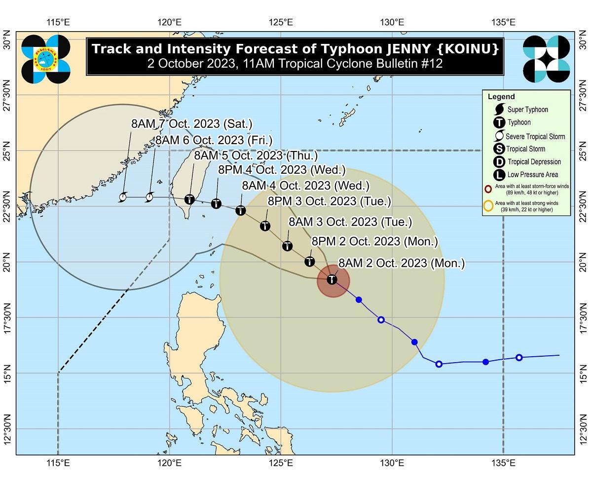
PAGASA said as of latest monitoring, Jenny was located 635 kilometers east Southeast of Basco, Batanes packing maximum sustained winds of 140 km per hour and gustiness of up to 170 km/h.
It was moving northwestward at 15 km/h.
PAGASA said the highest wind signal that may be raised is TCWS No. 2 although the potential for TCWS No. 3 is not ruled out at this time.
According to the weather bureau, Jenny may make landfall or close approach over the Batanes area.
“A landfall or close approach scenario over the Batanes area is still not ruled out, although the likelihood is decreasing,” it said.
A forecast accumulated rainfall of 50 to 100 millimeters is expected over Batanes, Babuyan Islands, Ilocos Norte, Ilocos Sur, and the northern portion of mainland Cagayan until Tuesday, PAGASA said.
Forecast rainfall is generally higher in elevated or mountainous areas, it pointed out.
PAGASA warned of possible flooding and rain-induced landslides in areas prone to these hazards and those with considerable amounts of rainfall for the past several days.
Jenny will keep enhancing the southwest monsoon or Habagat, bringing occasional to monsoon rains over the western parts of Central Luzon, Southern Luzon, Visayas, and Mindanao in the next three days.
Enhanced by Jenny, the southwest monsoon or Habagat will bring gusty conditions for the next three days over areas not under TCWS, especially in coastal and upland or mountainous areas exposed to winds.
Such conditions may be experienced in MIMAROPA, Western Visayas, and Bicol on Monday.
Gale warning
Due to Jenny, a gale warning is in effect for the coastal waters of the northern and eastern seaboards of Northern Luzon.
Moderate to rough seas up to four meters are expected over the coastal waters of Isabela.
“Mariners of motorbancas and similarly-sized vessels are advised to take precautionary measures while venturing out to sea and, if possible, avoid navigating in these conditions, especially if inexperienced or operating ill-equipped vessels,” PAGASA said.
Jenny will move generally northwestward until Tuesday before turning west northwestward or westward.
The typhoon is seen making landfall over the southern portion of Taiwan on Thursday afternoon or evening. It may exit the Philippine Area of Responsibility (PAR) over the Taiwan Strait between Thursday evening or Friday morning.
“Jenny is forecast to steadily intensify throughout the forecast period and may reach its peak intensity tomorrow,” PAGASA said.
“A slightly weakening trend may begin by mid-Wednesday due to a potential for dry air entrainment and increased wind shear prior to landfall over Taiwan,” it added. —Joviland Rita/KBK, GMA Integrated News
