

Typhoon Hanna slightly intensifies; Signal No. 1 up over Batanes, northern Babuyan Islands
Typhoon Hanna (international name: Haikui) on Sunday slightly intensified while moving closer to the coast of southern Taiwan, PAGASA said in its bulletin.
Tropical Cyclone Wind Signal (TCWS) No. 1 was raised over Batanes and the northern portion of Babuyan Group of Islands, particularly Babuyan Island and Calayan Island.
These areas will experience strong winds in 36 hours with wind speeds of 39 to 61 km/h, posing minimal to minor threat to life and property.
Batanes will also have 50 to 100 mm of rainfall on Sunday, PAGASA said.
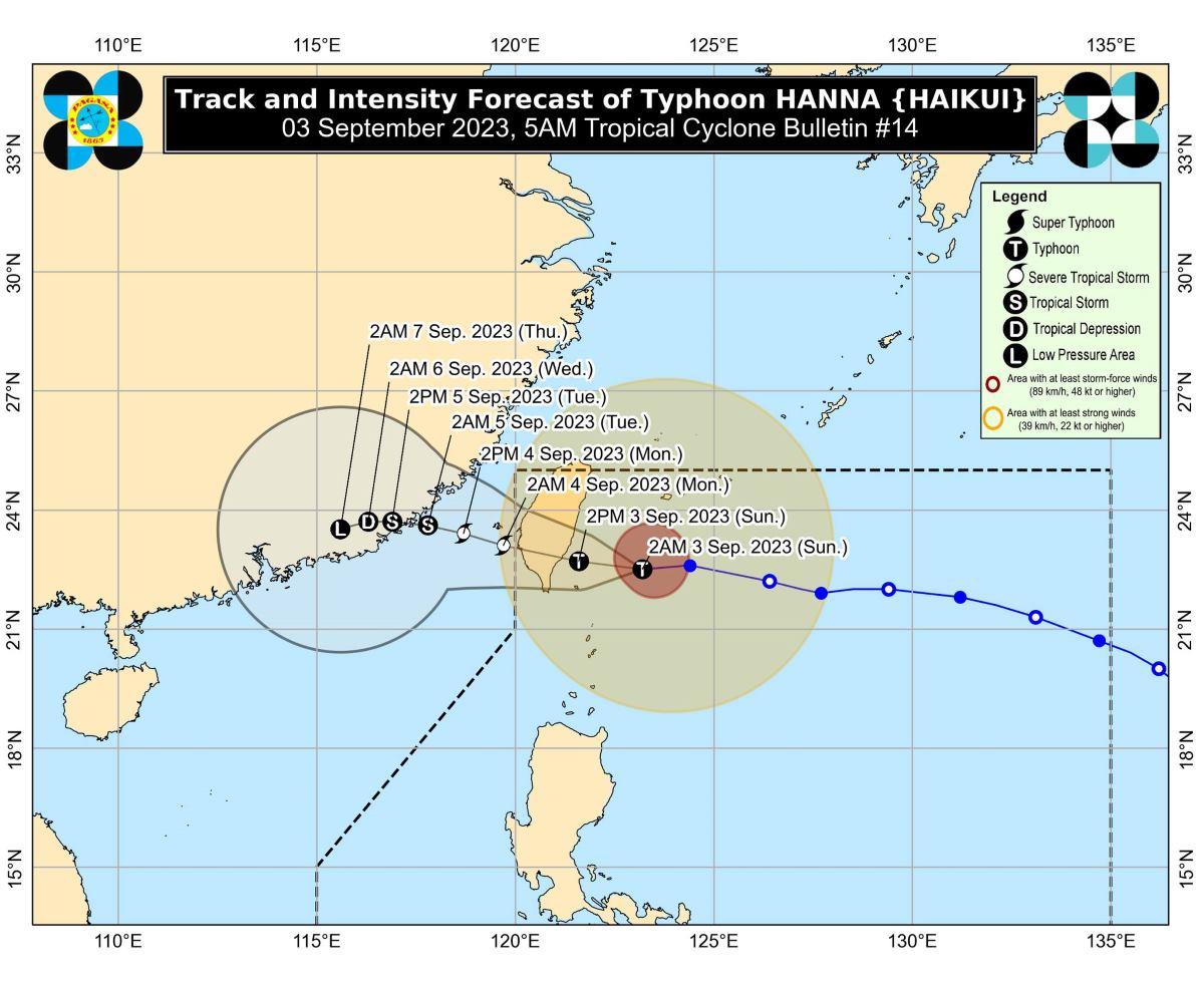
At 4 a.m., the eye of Hanna was estimated to be located at 215 km north northeast of Itbayat, Batanes.
Hanna has maximum sustained winds of 150 km/h near the center, gustiness of up to 185 km/h, and central pressure of 955 hPa.
From its center, strong to typhoon-force winds are extending outwards up to 560 km.
Hanna is expected to exit the Philippine Area of Responsibility (PAR) late evening on Sunday or early morning on Sunday as a severe tropical storm.
Habagat
Meanwhile, Hanna is enhancing the Southwest Monsoon (Habagat) which is expected to bring occasional to monsoon rains over the western portion of Luzon and Antique in the next three days.
Gusty conditions will thus be felt in the following areas not under any TCWS especially in coastal and upland or mountainous areas exposed to winds:
• Sunday: Babuyan Islands, Ilocos Region, Cordillera Administrative Region, Nueva Vizcaya, Zambales, Pampanga, Bataan, Aurora, Bulacan, Metro Manila, Calabarzon, Mimaropa, Bicol Region, Western Visayas, and the northern portion of Eastern Visayas.
• Monday: Batanes, Babuyan Islands, Ilocos Region, Abra, Benguet, Apayao, Nueva Vizcaya, Zambales, Pampanga, Bataan, Aurora, Bulacan, Metro Manila, Calabarzon, and most of Bicol Region, Mimaropa, and Western Visayas.
• Tuesday: Batanes, Babuyan Islands, Ilocos Region, Zambales, Bataan, Cavite, the northern portion of Quezon, Lubang Island, Romblon, and Kalayaan Islands.
Coastal waters
PAGASA raised a gale warning for the northern and western seaboards of Luzon, the eastern seaboards of Central and Southern Luzon, portions of seaboards of Northern Quezon, the southern seaboard of Southern Luzon, and the western seaboard of Visayas.
This is due to the combined influence of Hanna and the enhanced Southwest Monsoon.
Track, intensity
Hanna is expected to move generally westward then make landfall at or near peak intensity along the east coast of southern Taiwan on Sunday afternoon or evening.
It will then cross the rugged terrain of southern Taiwan on Sunday night, then weaken.
Hanna will then emerge over the Taiwan Strait then exit PAR.
From there, Hanna will move slowly westward or west northwestward over the Taiwan Strait, before making its final landfall along the coast of Guangdong or Fujian, China on Tuesday as a tropical storm.
PAGASA advised the public and disaster risk reduction and management offices concerned to take the necessary measures to protect life and property.
The next weather bulletin will be issued by PAGASA at 11 a.m.
Flights
Meanwhile, some flights were canceled on Sunday, September 3, due to the bad weather. —KG, GMA Integrated News

