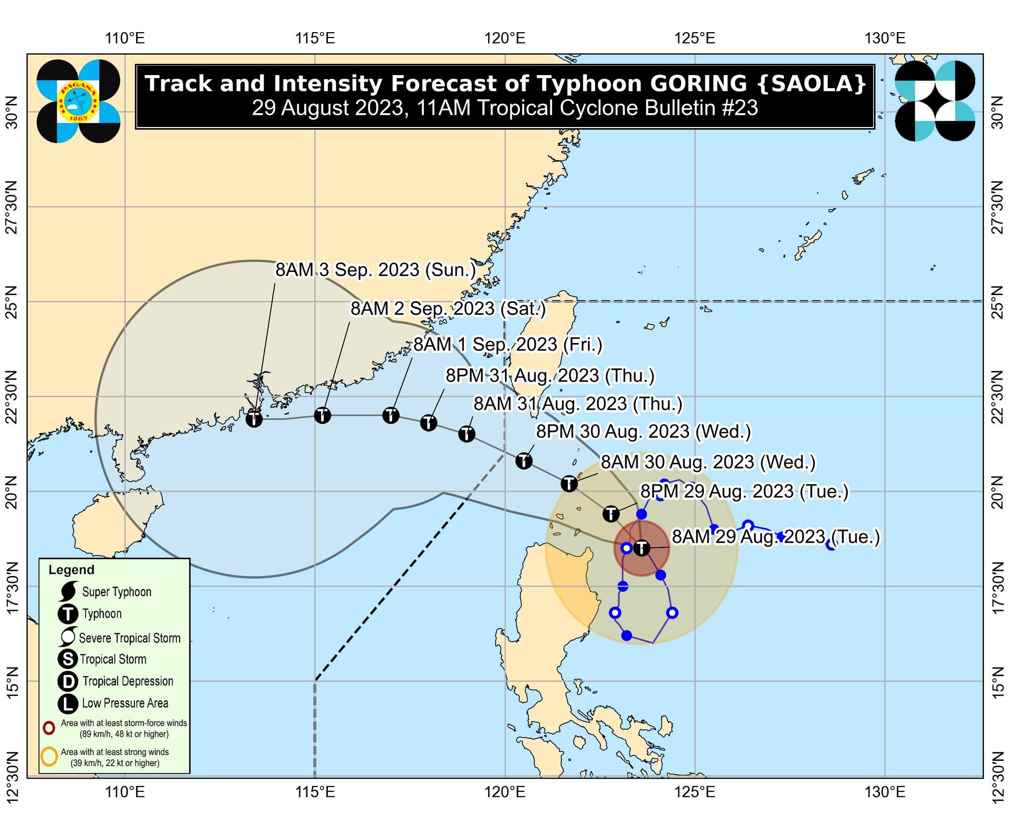
Signal No. 3 up in parts of Batanes, Babuyan Islands as Goring maintains strength

Tropical Cyclone Wind Signal (TCWS) No. 3 is hoisted over the southern portion of Batanes and northeastern portion of Babuyan Islands as Typhoon Goring maintained its strength on Tuesday morning, state weather bureau PAGASA said.
In its 11 a.m. bulletin, PAGASA raised the following Tropical Cyclone Wind Signals:
TCWS No. 3
- The southern portion of Batanes (Sabtang, Uyugan, Ivana, Mahatao, Basco)
- The northeastern portion of Babuyan Islands (Babuyan Is.)
TCWS No. 2
- The rest of Batanes and Babuyan Islands
- The extreme northeastern portion of mainland Cagayan (Santa Ana, Gonzaga)
TCWS No. 1
- The northern and eastern portions of mainland Cagayan (Camalaniugan, Pamplona, Santa Teresita, Baggao, Buguey, Claveria, Aparri, Ballesteros, Abulug, Sanchez-Mira, Santa Praxedes, Allacapan, Lal-Lo, Lasam, Peñablanca, Iguig, Amulung, Gattaran, Alcala, Santo Niño)
- The eastern portion of Isabela (Dinapigue, San Mariano, Ilagan City, Tumauini, San Pablo, Cabagan, Maconacon, Divilacan, Palanan)
- The northern portion of Apayao (Flora, Calanasan, Luna, Pudtol, Santa Marcela)
- The northern portion of Ilocos Norte (Vintar, Pasuquin, Burgos, Dumalneg, Adams, Pagudpud, Bangui)
PAGASA said that TCWS No. 4 is the highest possible warning level that it may raise due to the typhoon.
Goring was last located 180 kilometers east of Aparri, Cagayan packing maximum sustained winds of 155 km per hour and gustiness of up to 190 km/h, according to PAGASA.
The typhoon was moving northwestward slowly, it added.
PAGASA said Goring may pass very close or make landfall in the vicinity of Batanes between Wednesday morning and afternoon.
But, PAGASA said a slight southward shift in the track forecast may bring the eye and eyewall of the typhoon to the northern portion of Babuyan Islands.
Goring may reach the super typhoon category during this period, according to PAGASA.
“During this period, the typhoon is forecast to persist in strength by the time it passes very close or over Batanes (although gradual re-intensifying and reaching into a super typhoon category is not ruled out),” it said.
A forecast accumulated rainfall of 100-200 millimeters is expected over the northeastern portion of Babuyan Islands from Tuesday until Wednesday noon.
Meanwhile, 50-100 mm forecast accumulated rainfall may be experienced in Batanes, Babuyan Islands, Ilocos Norte, the northern portion of Abra, the northern portion of Apayao, and the northern and eastern portions of mainland Cagayan.
“Forecast rainfall are generally higher in elevated or mountainous areas,” PAGASA said.
“Under these conditions, flooding and rain-induced landslides are still expected especially in areas that are highly or very highly susceptible to these hazards as identified in hazard maps and in localities that experienced considerable amounts of rainfall for the past several days,” it added.
Enhanced Southwest Monsoon or Habagat will bring occasional or monsoon rains over the western portions of Central Luzon, Southern Luzon, and Visayas over the next three days.
Moderate to significant impacts from storm-force winds are possible in areas under TCWS No. 3, minor to moderate impacts from gale-force wind in TCWS No.2 areas, and minimal to minor impacts from strong winds in TCWS No. 1 areas.
Meanwhile, Habagat will bring gusty conditions over Aurora, Bataan, Bulacan, Metro Manila, CALABARZON, MIMAROPA, Bicol Region, Visayas, Dinagat Islands, Camiguin, and most of Zamboanga Peninsula on Tuesday.
A Gale Warning is in effect in the northern and eastern seaboards of Northern Luzon, the eastern and western seaboards of Central Luzon, the seaboards of Southern Luzon, seaboards of Visayas, and the northern seaboard of Mindanao.
“Disruption in civilian maritime activities is expected over these areas (e.g., suspension of sea travel) due to hazardous sea conditions,” PAGASA said.
Several courts have suspended work due to inclement weather, according to the Supreme Court.
The SC said court operations are suspended in the following:
Mamburao, Occidental Mindoro RTC Branch 44
Mamburao, Occidental Mindoro Family Court Branch 10
Mamburao, Occidental Mindoro MTC Branch 1
All courts in the Province of Batanes starting at noon.
Some flights were also canceled on Tuesday due to bad weather:
PAL Express (2P)
2P 2905/2906 Manila-Antique-Manila
2P 2932/2933 Manila-Basco-Manila
Cebu Pacific (5J)
5J 504/505 Manila-Tuguegarao-Manila
CebGo (DG)
DG 6177/6178 Manila-Masbate-Manila
Goring is seen to follow a mainly northwestward or west northwestward track across the Luzon Strait from Tuesday until it exits the Philippine Area of Responsibility (PAR) Wednesday evening or Thursday morning, PAGASA said.
—Joviland Rita/ VAL, GMA Integrated News


