

Goring now a super typhoon; Signal No. 3 up over extreme eastern Isabela
Tropical cyclone Goring intensified and became a super typhoon before dawn on Sunday, PAGASA said in its bulletin.
The extreme eastern portion of Isabela, particularly the towns of Divilacan and Palanan, was placed under Tropical Cyclone Wind Signal (TCWS) No. 3.
These areas will have storm-force winds in 18 hours with wind speeds of 89 to 117 km/h, which may pose moderate to significant threat to life and property.
TCWS No. 2 meanwhile was raised over:
- the eastern portion of mainland Cagayan (Peñablanca, Baggao, Gattaran, Lal-Lo, Gonzaga, Santa Teresita, Buguey, Santa Ana);
- the eastern portion of Isabela (Dinapigue, Ilagan City, Maconacon, Cabagan, Tumauini, San Pablo, Benito Soliven, San Mariano); and
- the extreme northern portion of Aurora (Dilasag, Casiguran).
Areas under TCWS No. 2 may have gale-force winds in 24 hours, with wind speeds of 62 to 88 km/h, with minor to moderate threat to life and property.
TCWS No. 1 on the other hand is in effect over the following areas:
- Babuyan Islands;
- the rest of mainland Cagayan;
- the rest of Isabela;
- Quirino;
- Nueva Vizcaya;
- Apayao;
- Kalinga;
- Abra;
- Mountain Province;
- Ifugao;
- the eastern portion of Benguet (Bokod, Buguias, Kabayan, Mankayan);
- the eastern portion of Ilocos Norte (Pagudpud, Adams, Vintar, Carasi, Nueva Era, Banna, Marcos, Dingras, Solsona, Piddig, Dumalneg, Bangui);
- the northeastern portion of Nueva Ecija (Carranglan, Pantabangan, Bongabon, Gabaldon, Laur, Rizal);
- the northern and central portions of Aurora (Dinalungan, Dipaculao, Baler, Maria Aurora, San Luis);
- Polillo Islands; and
- Calaguas Islands.
PAGASA said areas under TCWS No. 1 may experience strong winds in 36 hours with wind speeds of 39 to 61 km/h with minimal to minor threat to life and property.
Location
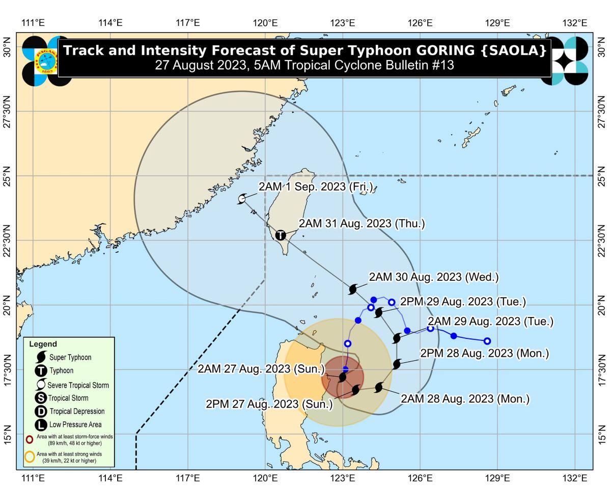
At 4 a.m., the eye of Goring was estimated to be located over the coastal waters of Palanan, Isabela.
Goring has maximum sustained winds of 185 km/h near the center, gustiness of up to 230 km/h, and central pressure of 935 hPa.
The super typhoon is slowly moving south southwestward.
From Goring's center, strong to typhoon-force winds are extending outwards up to 260 km.
Rainfall
On Sunday, the extreme eastern portion of Isabela will have more than 200 mm of rainfall.
The eastern portions of mainland Cagayan and Isabela will have 100 to 200 mm or rainfall, while 50 to 100 mm of rainfall may be expected in Ilocos Region, Apayao, Abra, Benguet, the northern portion of Aurora, the eastern portion of Nueva Vizcaya, and rest of mainland Cagayan and Isabela.
On Monday, the eastern portions of Babuyan Islands and mainland Cagayan may expect 50 to 100 mm of rainfall.
On Tuesday, the forecast is 100 to 200 mm of rainfall in Batanes and the eastern portion of Babuyan Islands; and 50 to 100 mm in the rest of Babuyan Islands and the northern portion of mainland Cagayan.
"Forecast rainfall are generally higher in elevated or mountainous areas. Under these conditions, flooding and rain-induced landslides are possible especially in areas that are highly or very highly susceptible to these hazards as identified in hazard maps and in localities that experienced considerable amounts of rainfall for the past several days," PAGASA said.
Southwest Monsoon
Meanwhile, Goring will enhance the Southwest Monsoon (Habagat).
The Habagat will cause occasional or monsoon rains over the western portions of Central Luzon, Southern Luzon, and Visayas over the next three days, PAGASA said.
The monsoon will also bring gusty conditions over the following areas not under TCWS, especially in coastal and upland/mountainous areas exposed to winds:
- Sunday: Aurora, Bataan, Metro Manila, Calabarzon, Mimaropa, Bicol Region, Visayas, Dinagat Islands, and Camiguin.
- Monday: Aurora, Bataan, Metro Manila, Calabarzon, Mimaropa, Bicol Region, Visayas, Dinagat Islands, Camiguin, and most of Zamboanga Peninsula.
- Tuesday: Aurora, Bataan, Bulacan, Metro Manila, Calabarzon, Mimaropa, Bicol Region, Visayas, Dinagat Islands, Camiguin, and most of Zamboanga Peninsula.
Gale warning
PAGASA raised a gale warning for the northern and eastern coastal waters of Luzon.
"Disruption in civilian maritime activities is expected over these areas (e.g., suspension of sea travel) due to hazardous sea condition," the weather bureau said.
Track, intensity outlook
On Sunday, Goring is expected to begin its loop over the Philippine Sea east of the Cagayan-Isabela area.
Goring will then turn northeastward and northward on Monday, then shift to a more northwestward movement on Tuesday.
On Wednesday evening or Thursday early morning, Goring may make landfall over the southern portion of Taiwan.
PAGASA said Goring will remain a super typhoon until it makes landfall over Taiwan.
However, it is seen to emerge over the Taiwan Strait and exit the Philippine Area of Responsibility as a severe tropical storm or a minimal typhoon.
PAGASA advised the public and disaster risk reduction and management offices concerned to take all necessary measures to protect life and property.
The next weather bulletin will be issued by PAGASA at 11 a.m. —KG, GMA Integrated News
