

Signal no. 3 raised over parts of Cagayan, Isabela as Goring intensifies
Tropical Cyclone Wind Signal (TCWS) No. 3 was raised over some parts of Cagayan and Isabela on Saturday morning as Typhoon Goring (international name: Saola) steadily intensified as it moved south southwestward over the sea east of Babuyan Islands, PAGASA said.
In its 11 a.m. bulletin, PAGASA said TCWS No. 3, with storm-force winds that have moderate to significant threat to life and property, will be in effect over the following:
- the northeastern portion of Cagayan (Santa Ana); and
- the extreme eastern portion of Isabela (Divilacan, Palanan).
TCWS No. 2, with gale-force winds bringing minor to moderate threat to life and property, meanwhile will be over the following:
- the eastern portion of Isabela (Dinapigue, San Mariano, Ilagan City, Maconacon, Cabagan, Tumauini, San Pablo);
- eastern portion of Cagayan (Peñablanca, Baggao, Gattaran, Lal-Lo, Gonzaga, Santa Teresita, Buguey); and
- and the northern portion of Aurora (Dilasag, Casiguran).
TCWS No. 1, which brings strong winds of minimal to minor threat to life and property, was raised over the following:
- Batanes;
- the rest of Cagayan including Babuyan Islands;
- central portion of Aurora (Dinalungan, Dipaculao);
- Quirino;
- the rest of Isabela;
- Apayao;
- eastern portion of Nueva Vizcaya (Kasibu, Quezon, Diadi, Bagabag, Solano, Villaverde);
- eastern portion of Ifugao (Lamut, Lagawe, Hingyon, Banaue, Mayoyao, Aguinaldo, Alfonso Lista);
- eastern portion of Mountain Province (Barlig, Natonin, Paracelis); and
- Kalinga.
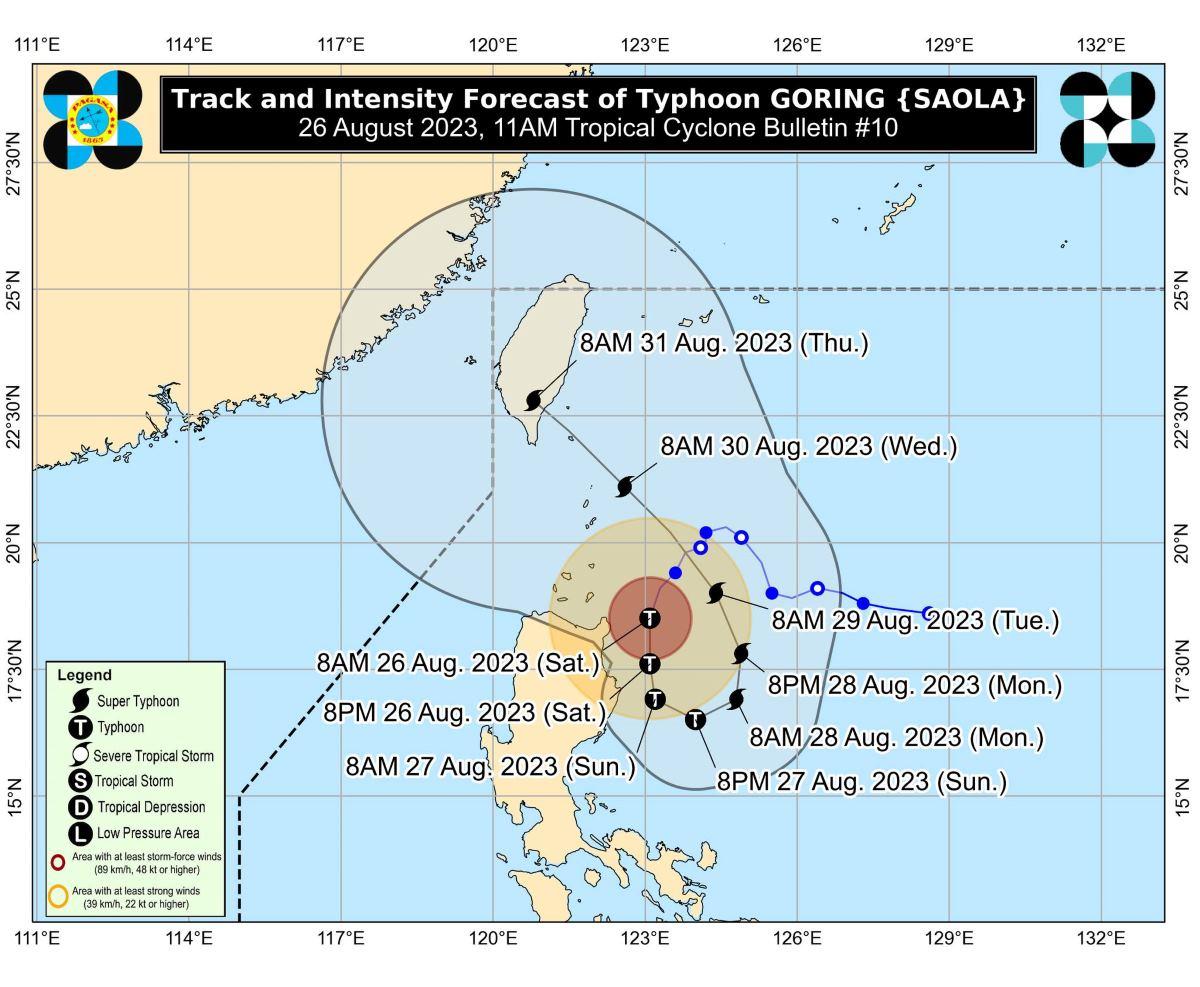
As of 10 a.m., the center of the eye of Goring was estimated based on all available data, including those from Aparri Weather Radar, at 155 km east of Aparri, Cagayan (18.3°N, 123.1°E)
Moving south southwestward at 10 km/h, Goring has maximum sustained winds of 150 km/h near the center, gustiness of up to 185 km/h, and central pressure of 965 hPa.
Its strong to typhoon-force winds are extending outwards up to 220 km from the center.
Habagat
PAGASA added that the Southwest Monsoon (Habagat) enhanced by Goring will bring occasional or monsoon rains over the western portions of Central Luzon, Southern Luzon, and Visayas over the next three days.
Further, the enhanced Southwest Monsoon will continue to bring gusty conditions over the following areas not under any TCWS on Saturday, especially in coastal and upland/mountainous areas exposed to winds:
- Bataan
- Metro Manila
- Calabarzon;
- Bicol Region; and
- most of Mimaropa.
Hazards on coastal waters
A gale warning is also in effect for the northern and eastern coastal waters of Northern Luzon and the eastern coastal waters of Central Luzon.
Sea travel will be risky for certain types or tonnage of vessels over the hazard areas. Disruption in civilian maritime activities is expected over these waters (e.g., suspension of sea travel).
Track and intensity outlook
PAGASA said Goring is forecast to move generally southward to southwestward on Saturday until Sunday, then will turn generally eastward to northeastward on Sunday. Afterwards, the typhoon will exit its looping path and move northwestward on Tuesday towards the sea east of Taiwan while moving on a consistent pace.
According to the state weather bureau, Goring is forecast to steadily intensify throughout most of the forecast period and may reach super typhoon category on Monday due to highly favorable environment. —KG, GMA Integrated News
