

PAGASA: TD Goring maintains strength, may reach super typhoon level
Tropical Depression Goring maintained its strength late Thursday morning and may develop into a typhoon or even a super typhoon, according to PAGASA's latest update.
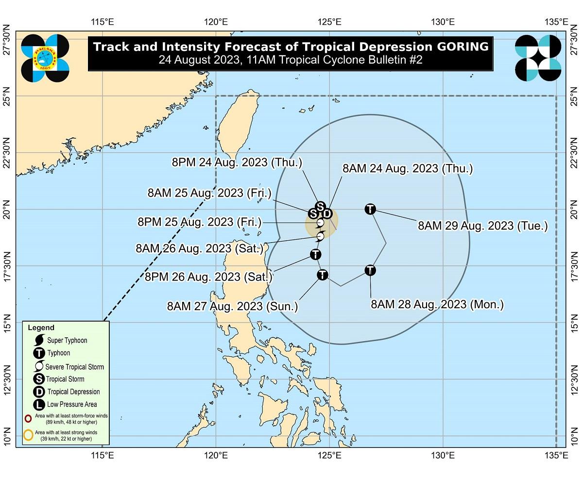
"While current intensity forecast indicate the progression towards typhoon category, the inherent volatility of attaining super typhoon category remains a possibility,” PAGASA said in its latest bulletin at 11 a.m.
PAGASA said Goring is seen to "steadily" intensify throughout the forecast period and may reach tropical storm category on Thursday night or early Friday morning.
It may be upgraded into a typhoon by Saturday during the southward segment of its looping track, it added.
On Thursday morning, Goring maintained its strength as it moved north northwestward over the Philippine Sea east of Basco, Batanes.
As of 10 a.m., Goring was located 355 kilometers east northeast of Calayan, Cagayan or 300 km east of Basco, Batanes. It was packing maximum sustained winds of 55 km per hour and gustiness of up to 70 km/h while moving west northwestward at 15 km/h.
Tropical Cyclone Wind Signals may be hoisted over areas in Northern Luzon starting Thursday night or Friday, according to PAGASA.
"The current forecast scenario shows that hoisting of Tropical Cyclone Wind Signals over areas in Northern Luzon may begin tonight or tomorrow in anticipation of the onset of tropical cyclone severe winds," PAGASA said.
"However, the hoisting may happen earlier should there be changes in the forecast scenario," it added.
While Goring is less likely to bring heavy rainfall in the next three days, PAGASA said any westward shift in its track forecast may result in heavy rainfall over portions of Cagayan Valley in the next three days.
Goring may also enhance the Southwest Monsoon or Habagat starting Sunday or Monday, which may cause occasional rains over the western portions of Central and Southern Luzon.
Gusty conditions may be experienced over most of Southern Luzon, Visayas, and portions of CARAGA starting Sunday or Monday. Such conditions are more likely in coastal and upland/mountainous areas exposed to winds.
For the next 24 hours, moderate to rough seas up to 2.8 meters are expected over the coastal waters of Extreme Northern Luzon and the northeastern portion of mainland Cagayan, PAGASA said.
PAGASA advised mariners of motor bancas and similarly-sized vessels to avoid navigating in these conditions, especially if inexperienced or operating ill-equipped vessels.
After 12 hours of moving generally northwestward, PAGASA said Goring is forecast to turn generally southward while over the waters off the eastern coast of Cagayan Valley.
Over the next five days, PAGASA said Goring will follow a generally looping track and may likely return to a more northward movement by late Monday or Tuesday. —Joviland Rita/KBK, GMA Integrated News
