

Falcon now a severe tropical storm; Habagat to bring rains over parts of Luzon, Visayas
Tropical Storm Falcon (international name: Khanun) developed into a severe tropical storm before dawn on Sunday and continues to enhance the Southwest Monsoon (Habagat) which will bring occasional to monsoon rains over the western sections of Luzon and Visayas in the next three days, PAGASA said in its bulletin.
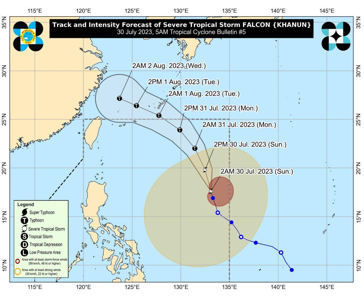
At 4 a.m., the center of Falcon was estimated to be located at 1,190 km east of Northern Luzon.
Falcon has maximum sustained winds of 95 km/h near the center, gustiness of up to 115 km/h, and central pressure of 985 hPa.
The severe tropical storm is moving north northwestward at 15 km/h.
From its center, strong to storm-force winds are extending outwards up to 900 km.
PAGASA has not raised any tropical cyclone wind signals (TCWS) at this time. It further said raising any TCWS due to Falcon is unlikely due to the current forecast scenario.
Rainfall
PAGASA said more rain may be expected in elevated or mountainous areas.
Flooding and rain-induced landslides may occur especially in areas prone to these hazards and in localities that had considerable amounts of rainfall in the past few days.
Winds
Gusty conditions may be expected due to the monsoon over the following areas, especially those near the coast or in upland/mountainous places exposed to winds:
- Sunday: Zambales, Bataan, Pampanga, Bulacan, Metro Manila, Occidental Mindoro, Palawan, Romblon, Northern Samar, and most of Calabazon, Bicol Region and Western Visayas;
- Monday: Ilocos Norte, Pangasinan, Zambales, Bataan, Pampanga, Bulacan, Metro Manila, Occidental Mindoro, Palawan, Romblon, Northern Samar, and most of Calabarzon, Bicol Region and Western Visayas; and
- Tuesday: Ilocos Region, Abra, Benguet, Zambales, Bataan, Bulacan, Metro Manila, Bicol Region, and most of CALABARZON, MIMAROPA, and Western Visayas.
Coastal waters
PAGASA raised a gale warning over several coastal waters along the western seaboard of Luzon due to the Southwest Monsoon.
This would make sea travel risky for small seacraft.
"For larger vessels, operating in gale conditions requires experience and properly equipped vessels. Mariners without proper experience or operating ill-equipped vessels are advised to remain in port or seek safe harbor," PAGASA said.
Track, intensity outlook
Falcon is expected to move north northwestward on Sunday, then northwestward on Monday.
It is forecast to exit the Philippine Area of Responsibility on Monday evening or early Tuesday morning.
"Outside the PAR region, FALCON will turn west northwestward and pass close to Okinawa Islands in the Ryukyu Archipelago on Tuesday morning before entering the East China Sea," PAGASA said.
Falcon is expected to steadily intensify in the next three days and become a typhoon between late Sunday evening or early Monday morning. It will reach peak intensity on Tuesday.
PAGASA advised the public and disaster risk reduction and management offices concerned to take the necessary measures to protect life and property.
The next weather bulletin will be issued by PAGASA at 11 a.m. —KG, GMA Integrated News
