

Tropical depression intensifies into tropical storm, may enter PAR on Saturday
The tropical depression outside the Philippine Area of Responsibility has intensified into a tropical storm and will be named "Falcon" once inside PAR, PAGASA reported.
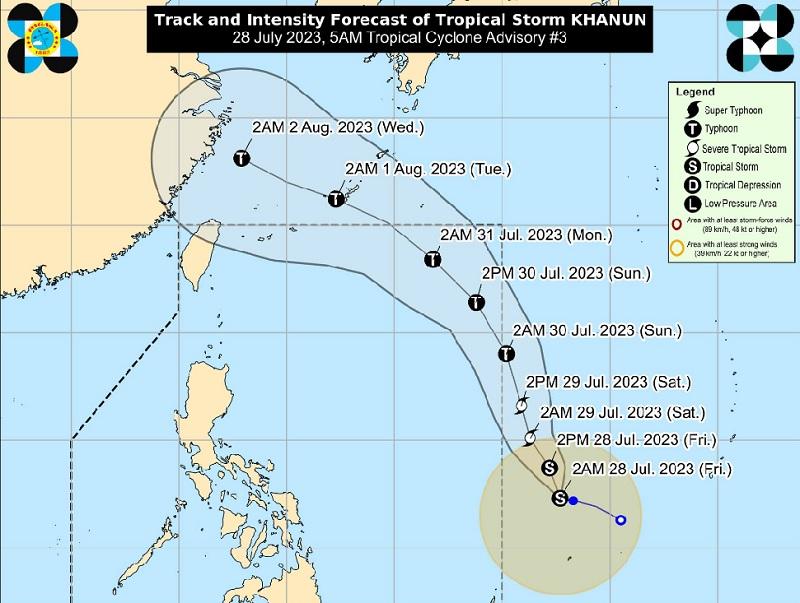
In a Tropical Cyclone advisory issued at 5 a.m., the Tropical Storm Khanun was estimated at 1,315 kilometers east of Eastern Visayas outside PAR packing maximum sustained winds of 65 kilometers per hour near the center, gustiness of up to 80 km/h, and central pressure of 1000 hPa.
Khanun is moving west southwestward at the speed of 15 km/h with strong to gale-force winds extend outwards up to 470 km from the center.
General outlook for the forecast period
"After a period of generally west northwestward movement in the near term, Khanun is forecast to turn and move generally north northwestward until Sunday afternoon over the Philippine Sea," said PAGASA.
"On the track forecast, the tropical cyclone may enter the PAR region between late evening on Saturday and Sunday morning. Once inside the PAR, the domestic name Falcon will be assigned to this tropical cyclone," the agency added.
PAGASA also said that "shifts in the track forecast remains possible as the circulation of Khanun further consolidates."
However, Khanun is forecast to continuously intensify within the next 5 days and become a typhoon late evening on Saturday or on Sunday early morning and reach its peak intensity by late Monday or early Tuesday.
Khanun may also enhance the Southwest Monsoon and trigger occasional or monsoon rains over the western portions of Luzon and Visayas beginning Saturday or Sunday.
"However, the magnitude, extent, and timing of monsoon enhancement and resulting rainfall may still change due to dependence of Southwest Monsoon enhancement on the intensity and movement of this tropical cyclone," said the weather bureau. — BAP, GMA Integrated News
