

Egay maintains northwestward path as Signal No. 2 remains over 8 areas
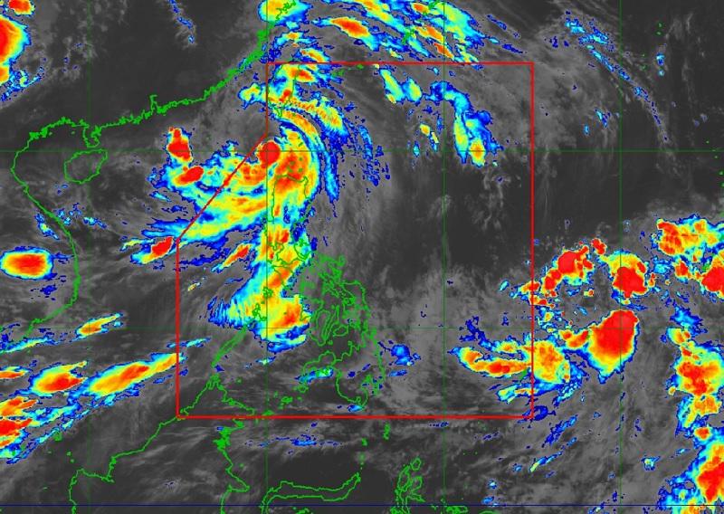
Typhoon Egay continues to weaken over Luzon Strait west of Batanes as Signal No. 2 remains hoisted over eight areas, PAGASA reported.
In the Tropical Cyclone Bulletin posted at 5 a.m., the weather bureau reported that the center of the eye of Typhoon Egay was estimated at 195 kilometers west of Basco, Batanes packing maximum sustained winds of 150 kilometers per hour near the center, gustiness of up to 185 km/h, and central pressure of 955 hPa.
Egay continues to move northwestward at a speed of 15 km/h with strong to typhoon-force winds extend outwards up to 630 km from the center.
Tropical Cyclone Wind Signal No. 2 is hoisted over the following areas:
- Batanes
- Cagayan
- Babuyan Islands
- Apayao
- Kalinga
- Abra
- Ilocos Norte
- the northern and central portion of Ilocos Sur (Magsingal, San Esteban, Banayoyo, Burgos, City of Candon, Santiago, San Vicente, Santa Catalina, Lidlidda, Nagbukel, Sinait, San Ildefonso, Galimuyod, City of Vigan, San Emilio, Cabugao, Caoayan, San Juan, Santa, Bantay, Santo Domingo, Santa Maria, Narvacan)
TCWS No.1 is hoisted over the following areas:
- Isabela
- Quirino
- Nueva Vizcaya
- Mountain Province
- Ifugao
- Benguet
- the rest of Ilocos Sur
- La Union
- Pangasinan
- Aurora
- Nueva Ecija
- Tarlac
- the northern portion of Zambales (Botolan, Iba, Candelaria, Cabangan, Palauig, Santa Cruz, Masinloc)
Hazards affecting land areas
Forecast accumulated rainfall from Thursday to Friday afternoon is 50-100 mm in Ilocos Norte, Ilocos Sur, La Union, Pangasinan, and the western portions of Abra and Benguet.
Forecast rainfall are generally higher in elevated or mountainous areas where flooding and rain-induced landslides are highly likely to occur especially in areas that are highly or very highly susceptible to these hazards.
The Southwest Monsoon or Habagat enhanced by Egay will continue to bring occasional to monsoon rains over the western portions of Central Luzon and Southern Luzon in the next three days.
Ilocos Norte, Batanes, and Babuyan Islands will be stormy due to Typhoon Egay where flooding or landslides may occur due to heavy to intense rains with significant to extreme threat to lives and properties due to strong winds.
Cordillera Administrative Region, the rest of Ilocos Region, mainland Cagayan, and Isabela will have rains with gusty winds due to the typhoon. Flooding or landslides may occur due to moderate to heavy rains with minimal to minor threat to lives and properties due to strong winds.
Zambales, Bataan, Occidental Mindoro, Northern Palawan including Calamian and Cuyo Islands will experience monsoon rains due to Egay and the habagat with possible flooding or landslides due to scattered to widespread rains.
Metro Manila, the rest of Cagayan Valley, the rest of Central Luzon, the rest of MIMAROPA, and CALABARZON will have occasional rains also due to Egay and the habagat with flooding or landslides occurring due to moderate to heavy rains.
The Bicol Region and Western Visayas will have cloudy skies with scattered rain showers and thunderstorms due to the habagat with flash floods or landslides possibly occurring due to moderate to at times heavy rains.
In Mindanao and the rest of Visayas will have partly cloudy to cloudy skies with isolated rain showers or thunderstorms due to the habagat and localized thunderstorms with flash floods or landslides occurring during severe thunderstorms.
Severe Winds
The bureau reported that minor to moderate impacts from gale-force winds may occur within areas under Signal No. 2 while minimal to minor impacts from strong winds may also occur in the areas where Signal No.1 is hoisted.
The enhanced Southwest Monsoon will continue to bring gusty conditions over the following areas not under any Wind Signal, especially in coastal and upland/mountainous areas exposed to winds over Luzon and Western Visayas.
"There is a moderate to high risk of storm surge which may cause flooding in the low-lying and exposed coastal areas of Batanes, the northwestern portion of Cagayan including Babuyan Islands, Ilocos Norte, and extreme northern portion of Ilocos Sur," PAGASA reported, adding that maximum surge heights may reach 3.0 m some of the warning areas.
Gale Warning is in effect over several coastal waters along the seaboards of Luzon and the eastern and western seaboards of Visayas and all mariners are advised to remain in port or seek safe harbor until winds and waves subside.
Track and Intensity Outlook
The typhoon is forecast to track northwestward or north northwestward over the Luzon Strait, the sea southwest of Taiwan, and the Taiwan Strait throughout the forecast period while gradually accelerating.
Egay may exit the Philippine Area of Responsibility (PAR) this morning or afternoon. — BAP, GMA Integrated News
