PAGASA: Egay starting ‘violent conditions’ in eastern Babuyan

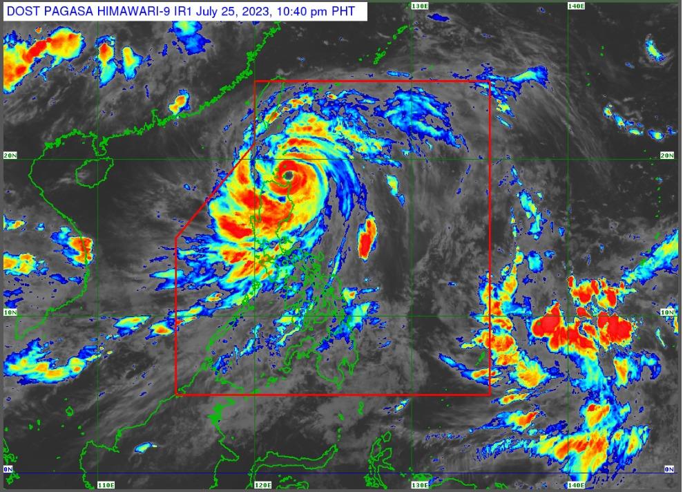
Violent conditions are starting over the eastern portion of the Babuyan Islands as Typhoon Egay moves over the coastal waters of Calayan in Cagayan, PAGASA said late Tuesday night.
According to its tropical cyclone bulletin at 11 p.m., PAGASA raised Signal No. 4 over the northern portion of Cagayan, the Babuyan Islands, and the northern portion of Ilocos Norte.
"Violent, life-threatening conditions within the eyewall are expected for Babuyan Islands and possible for the coastal municipalities of mainland Cagayan in the next six hours," PAGASA said.
"Significant to severe impacts from typhoon-force winds may be experienced within the areas under Wind Signal No. 4," it added.
PAGASA said Egay is packing maximum stustained winds of 175 kph near the center and gustiness of up to 215 kph.
The center of the eye was estimated to be in the coastal waters of Calayan, Cagayan.
It moving west northwestward at 10 kph.
"There is a high risk of storm surge which may cause flooding in the low-lying and exposed coastal areas of Batanes, Cagayan including Babuyan Islands, Ilocos Norte, and portions of Isabela and Ilocos Sur," PAGASA said.
"Maximum surge heights may exceed 3.0 m in most of the warning areas," it added.
Other areas under storm signals are the following.
Signal No. 3
- Batanes
- the rest of Cagayan
- Apayao
- the northern portion of Kalinga (Rizal, Pinukpuk, Balbalan)
- the northern portion of Abra (Tineg, Lagayan, Lacub, Danglas)
- the rest of Ilocos Norte
Signal No. 2
- Isabela
- the rest of Kalinga
- Mountain Province
- Ifugao
- the northern portion of Benguet (Bakun, Mankayan, Buguias, Kabayan, Kibungan, Atok)
- the rest of Abra
- Ilocos Sur
- the northern portion of La Union (Bangar, Sudipen, Luna, Balaoan, Santol)
Signal No. 1
- Aurora
- Quirino
- Nueva Vizcaya
- the rest of Benguet
- the rest of La Union
- Pangasinan
- Nueva Ecija
- Tarlac
- Pampanga
- Bulacan
- Zambales
- Bataan
- Metro Manila
- Rizal
- Cavite
- Laguna
- the northern portion of Batangas (Talisay, City of Tanauan, Santo Tomas, Balete, Malvar, Lipa City)
- the northern and central portion of Quezon (Pitogo, Calauag, Infanta, Lopez, Guinayangan, Unisan, Plaridel, Quezon, Alabat, Padre Burgos, Mauban, General Nakar, Perez, Agdangan, Gumaca, Atimonan, Real, Tagkawayan, Lucena City, Pagbilao, Lucban, Sampaloc, City of Tayabas, Dolores, Sariaya, Candelaria, Tiaong, San Antonio) including Polillo Islands
- Camarines Norte
- the northern portion of Camarines Sur (Siruma, Tinambac, Goa, Lagonoy, Caramoan, Cabusao, Sipocot, Garchitorena, Ragay, Del Gallego, Calabanga, Presentacion, Lupi), and the northern portion of Catanduanes (Pandan, Bagamanoc, Panganiban, Viga, Caramoran)
Heavy rains
The forecast accumulated rainfall from Tuesday night to Wednesday evening is 100 millimeters to 200 millimeters in Batanes, the rest of Cagayan, the rest of Apayao, the western portion of Kalinga, the western portion of Mountain Province, the western portion of Benguet, and La Union.
For the northern portion of Isabela, the western portion of Nueva Vizcaya, the rest of Kalinga, the rest of Mountain Province, the western portion of Ifugao, the rest of Benguet, Pangasinan, and Zambales, it will be 50 millimeters to 100 millimeters.
"Forecast rainfall are generally higher in elevated or mountainous areas. Under these conditions, flooding and rain-induced landslides are highly likely especially in areas that are highly or very highly susceptible to these hazards as identified in hazard maps and in localities that experienced considerable amounts of rainfall for the past several days," PAGASA said.
Egay will enhance the Southwest Monsoon which will continue to bring occasional to monsoon rains over the western portions of Central Luzon, Southern Luzon, and Visayas in the next three days. —NB, GMA Integrated News


