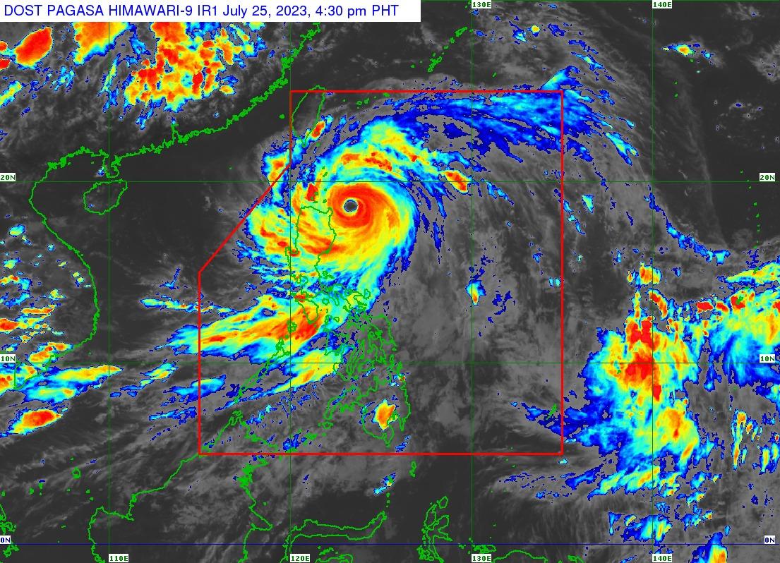
Signal No. 5 up in part of Babuyan Islands as Egay maintains strength

Tropical Cyclone Wind Signal (TCWS) No. 5 is raised over the eastern portion of Babuyan Islands (Camiguin Island) as Super Typhoon Egay is expected to make landfall or pass very close to the Babuyan Islands-northeastern mainland Cagayan area between Tuesday evening and Wednesday morning, according to state weather bureau PAGASA.
In its 2 p.m. bulletin on Tuesday, PAGASA raised the following Tropical Cyclone Wind Signal (TCWS) in parts of the country:
TCWS No. 5
- The eastern portion of Babuyan Islands (Camiguin Island)
TCWS No. 4
- The northeastern portion of mainland Cagayan (Santa Ana and Gonzaga)
- The rest of Babuyan Island
TCWS No. 3
- The northeastern portion of Isabela (Divilacan, Maconacon, Palanan, Santa Maria, San Pablo, Santo Tomas, Cabagan, Tumauini)
- The rest of Cagayan
- Apayao
- Eastern portion of Ilocos Norte (Vintar, Adams, Pagudpud, Dumalneg, Nueva Era, Carasi, Bangui, Piddig, Solsona)
- Northeastern portion of Kalinga (Rizal, Pinukpuk)
- Batanes
TCWS No. 2
- The rest of Isabela
- Northern and central portions of Aurora (Dilasag, Casiguran, Dinalungan, Dipaculao)
- Quirino
- The rest of Kalinga
- Northeastern portion of Nueva Vizcaya (Kasibu, Quezon, Diadi, Bagabag, Ambaguio, Villaverde, Solano, Bayombong)
- The rest of Ilocos Norte
- Ilocos Sur
- Abra
- Mountain Province
- Ifugao
- Northern portion of Benguet (Bakun, Mankayan, Buguias, Kabayan, Kibungan, Atok)
- Northern portion of La Union (Bangar, Sudipen, Luna, Balaoan, Santol)
TCWS NO. 1
- Quezon including Pollilo Islands
- The rest of Aurora
- The rest of Nueva Vizcaya
- The rest of Benguet
- The rest of La Union
- Nueva Ecija
- Pangasinan
- Tarlac
- Zambales
- Bulacan
- Pampanga
- Bataan
- Marinduque
- Cavite
- Metro Manila
- Rizal
- Laguna
- Batangas
- Camarines Norte
- Camarines Sur
- Albay
- Catanduanes
Egay was located 230 kilometers east northeast of Tuguegarao City, Cagayan or 240 km east of Aparri, Cagayan packing a maximum sustained winds of 185 km per hour and with gustiness of up to 230 km/h.
It was moving northwestward at 20 km/h.
PAGASA said Egay may make a landfall or pass very close to the Babuyan Islands-northeastern mainland Cagayan area between late Thursday evening and Wednesday morning.
Due to slight northward or southward shift in this segment of the track, Egay may also make a landfall or close approach over northern mainland Cagayan or Batanes.
It is forecast to exit the Philippine Area of Responsibility on Thursday morning, according to PAGASA.
Egay is nearing its peak intensity, PAGASA said. A short window of high favorable environment in the near term will allow it to either maintain its intensity in the next 12 hour or slightly intensify, it added. —Joviland Rita/ VAL, GMA Integrated News


