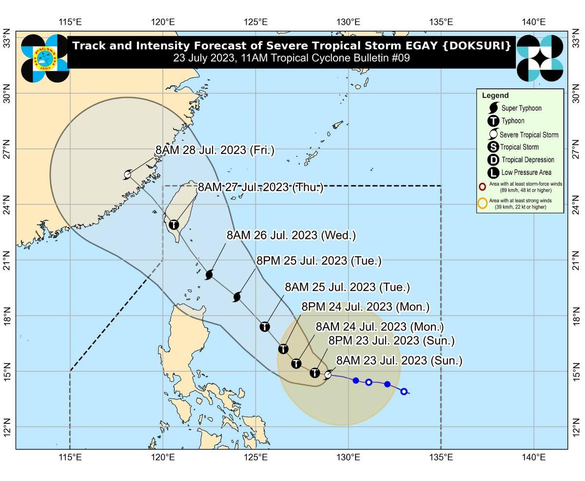
Egay intensifies into severe tropical storm

Egay (international name: Doksuri) has intensified into a severe tropical storm on Sunday morning, according to state weather bureau PAGASA.
According to PAGASA's 11 a.m. bulletin, the center of the tropical cyclone was last estimated at 610 kilometers east of Daet, Camarines Norte .
It was heading westward at a speed of 15 kilometers per hour (km/h) with maximum sustained winds of 95 km/h near the center, gustiness of up to 115 km/h, and a central pressure of 985 hPa.
Egay also has strong to storm-force winds that extend outwards up to 460 km from the center.
In anticipation of the arrival of strong breeze to near-gale conditions directly caused by Egay, PAGASA said wind signals may be raised in some areas in Bicol Region and Eastern Visayas within the day.
“Current forecast scenario shows that the highest wind signal that may be hoisted will be Wind Signal No. 3 or 4, potentially over Extreme Northern Luzon. However, should a southward shift in the track occur, higher wind signals may be hoisted,” PAGASA added.
Egay may also enhance the Southwest Monsoon (Habagat), bringing occasional rains over several areas of the country in the next three days.
Both the tropical cyclone and the enhanced Southwest Monsoon may thus bring gusty conditions over the following areas, especially in coastal and upland or mountainous areas exposed to winds:
Sunday: Mimaropa, Visayas, and the northern portions of Zamboanga Peninsula, Northern Mindanao, and Caraga.
Monday: Calabarzon, Mimaropa, Visayas, Zamboanga Peninsula, and the northern portions of Northern Mindanao and Caraga.
Tuesday: Most of Luzon and Visayas, the northern portions of Zamboanga Peninsula, and Dinagat islands
Coastal waters
PAGASA said a gale warning is in effect over several coastal waters along the eastern seaboards of Southern Luzon, Visayas, and Northeastern Mindanao due to Egay.
In the next 24 hours, Egay may also bring rough seas (2.8 to 3.5 meters) over the coastal waters along the eastern seaboards of Luzon and Visayas that are outside the Gale Warning area.
PAGASA warned that sea travel is risky for small seacraft, and operating in gale conditions requires experience and properly equipped vessels even for larger vessels. Mariners without proper experience or operating ill-equipped vessels were also advised to remain in port or seek safe harbor.
Track and intensity
Egay is expected to reach typhoon category within 24 hours and may become a super typhoon on Tuesday, according to PAGASA.
“Rapid intensification is likely within the next 72 hours due to favorable atmospheric and oceanic conditions,” it added.
In the next 12 hours, Egay is still forecast to move slowly and accelerate west northwestward or westward until Monday morning. Afterwards, it will turn generally northwestward for the remainder of the forecast period.
A slight weakening trend may then begin on Wednesday and will continue until the tropical cyclone makes landfall over Taiwan on Thursday. —Giselle Ombay/KG, GMA Integrated News


