

Egay slightly intensifies, nears severe tropical storm category
Tropical Storm Egay (international name: Doksuri) slightly intensified on Sunday and is expected to develop into a severe tropical storm, PAGASA said in its weather forecast.
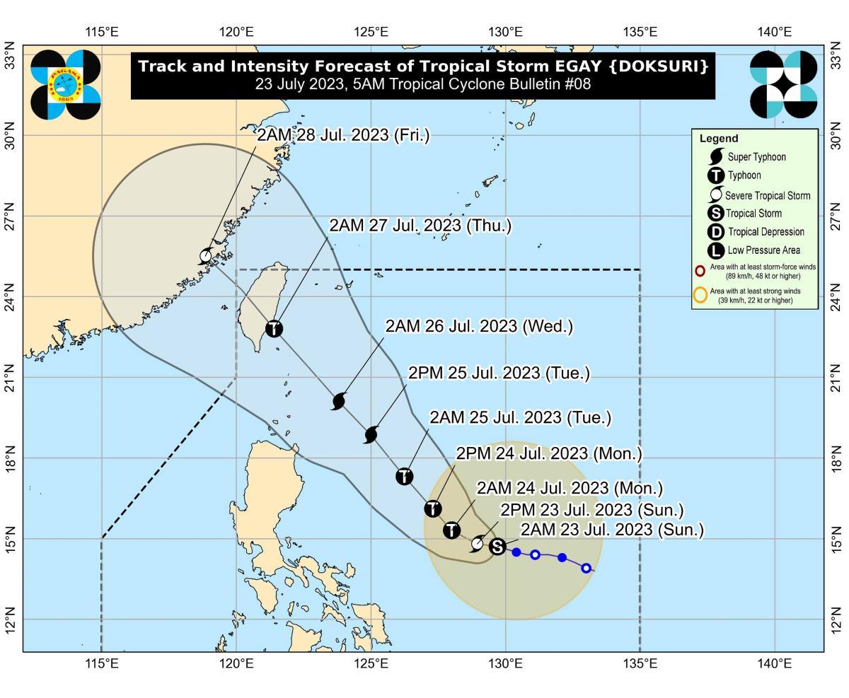
At 4 a.m. Sunday, Egay's center was estimated to be located at 585 km east northeast of Virac, Catanduanes or 705 km east of Daet, Camarines Norte.
Egay has maximum sustained winds of 85 km/h near the center, gustiness of up to 105 km/h, and central pressure of 990 hPa.
The tropical storm is moving west northwestward at 10 km/h.
From Egay's center, strong to gale-force winds are extending outwards up to 460 km.
PAGASA has not raised any tropical cyclone wind signal (TCWS) at this time.
Within 24 hours, Egay is expected to develop into a typhoon and reach super typhoon category on Tuesday.
Rainfall
The northern portion of Catanduanes will have 100 to 200 mm of rain on Monday.
Camarines Norte, the northern portion of Camarines Sur, and the rest of Catanduanes meanwhile may expect 50-100 mm of rain.
On Tuesday, Babuyan Islands and the northern portion of mainland Cagayan may experience 100 to 200 mm of rain.
Batanes, the rest of Cagayan, the northern portion of Apayao, Ilocos Norte, Abra, and the northern portion of Ilocos Sur on the other hand may have 50-100 mm of rain on Tuesday.
The amount of rainfall may be higher in elevated or mountainous areas, PAGASA said.
"Under these conditions, flooding and rain-induced landslides are possible, especially in areas that are highly or very highly susceptible to these hazard as identified in hazard maps and in localities that experienced considerable amounts of rainfall for the past several days," it added.
The tropical storm is also expected to enhance the Southwest Monsoon (Habagat).
As a result, several areas in the country will have occasional rains in the next three days.
Severe winds
PAGASA said TCWS may be raised in some areas in the Bicol Region and Eastern Visayas on Sunday as strong breeze to near-gale conditions directly caused by Egay are expected.
The highest TCWS that may be raised would be Signal No. 3 or 4, potentially over Extreme Northern Luzon, PAGASA said.
Higher TCWS may be hoisted should Egay turn southward, it added.
Gusty conditions due to Egay and the enhanced Habagat may be expected in the following areas, especially in coastal and upland/mountainous areas exposed to winds:
• Sunday: Mimaropa, Visayas, and the northern portions of Zamboanga Peninsula, Northern Mindanao, and Caraga.
• Monday: Calabarzon, Mimaropa, Visayas, Zamboanga Peninsula, and the northern portions of Northern Mindanao and Caraga.
• Tuesday: Most of Luzon and Visayas and the northern portions of Zamboanga Peninsula, Northern Mindanao, and Caraga.
Coastal waters
PAGASA raised a gale warning over several coastal waters along the eastern seaboards of Southern Luzon and Visayas due to Egay.
"Sea travel is risky for small seacrafts," PAGASA said.
"For larger vessels, operating in gale conditions requires experience and properly equipped vessels. Mariners without proper experience or operating ill-equipped vessels are advised to remain in port or seek safe harbor," it added.
Moderate to rough seas (up to 3.5 meters) over the coastal waters along the eastern seaboards of Luzon and Visayas that are outside the gale warning area are to be expected in the next 24 hours.
"Mariners of small seacrafts are advised to take precautionary measures when venturing over these waters. If inexperienced or operating ill-equipped vessels, avoid navigating in these conditions," the weather bureau said.
Track, intensity outlook
"EGAY is forecast to slowly accelerate west northwestward or westward until tomorrow early morning," PAGASA said.
For the remainder of the forecast period, Egay is expected to turn northwestward.
"Although the latest track forecast shows that EGAY will remain offshore for most of the forecast period, a close approach or landfall in the vicinity of Extreme Northern Luzon is still not ruled out based on the forecast confidence cone," PAGASA said.
On Wednesday, Egay will be closest to Extreme Northern Luzon.
On Thursday morning, Egay is seen to make landfall over Taiwan's east coast.
"Based on current and forecast behavior of the ridge of high pressure to the north of EGAY, a 'westward shift' in the track forecast remains a possibility," PAGASA said.
The weather bureau said Egay is expected to likely rapidly intensify within 72 hours "due to favorable atmospheric and oceanic conditions."
On Wednesday Egay may start to weaken slightly and will continue to do so until it makes landfall over Taiwan.
"Interaction with the mountainous terrain of Taiwan will result in further weakening – a trend which will continue until the tropical cyclones makes another landfall on mainland China," PAGASA said.
The weather bureau advised the public and disaster risk reduction and management offices concerned to take all necessary measures to protect life and property.
The next weather bulletin will be issued by PAGASA at 11 a.m. —KG, GMA Integrated News
