

Egay maintains strength while moving west northwest, enhances Habagat
Tropical Depression Egay (international name: Doksuri) maintained its strength while moving west northwestward on Saturday, PAGASA said in its weather forecast.
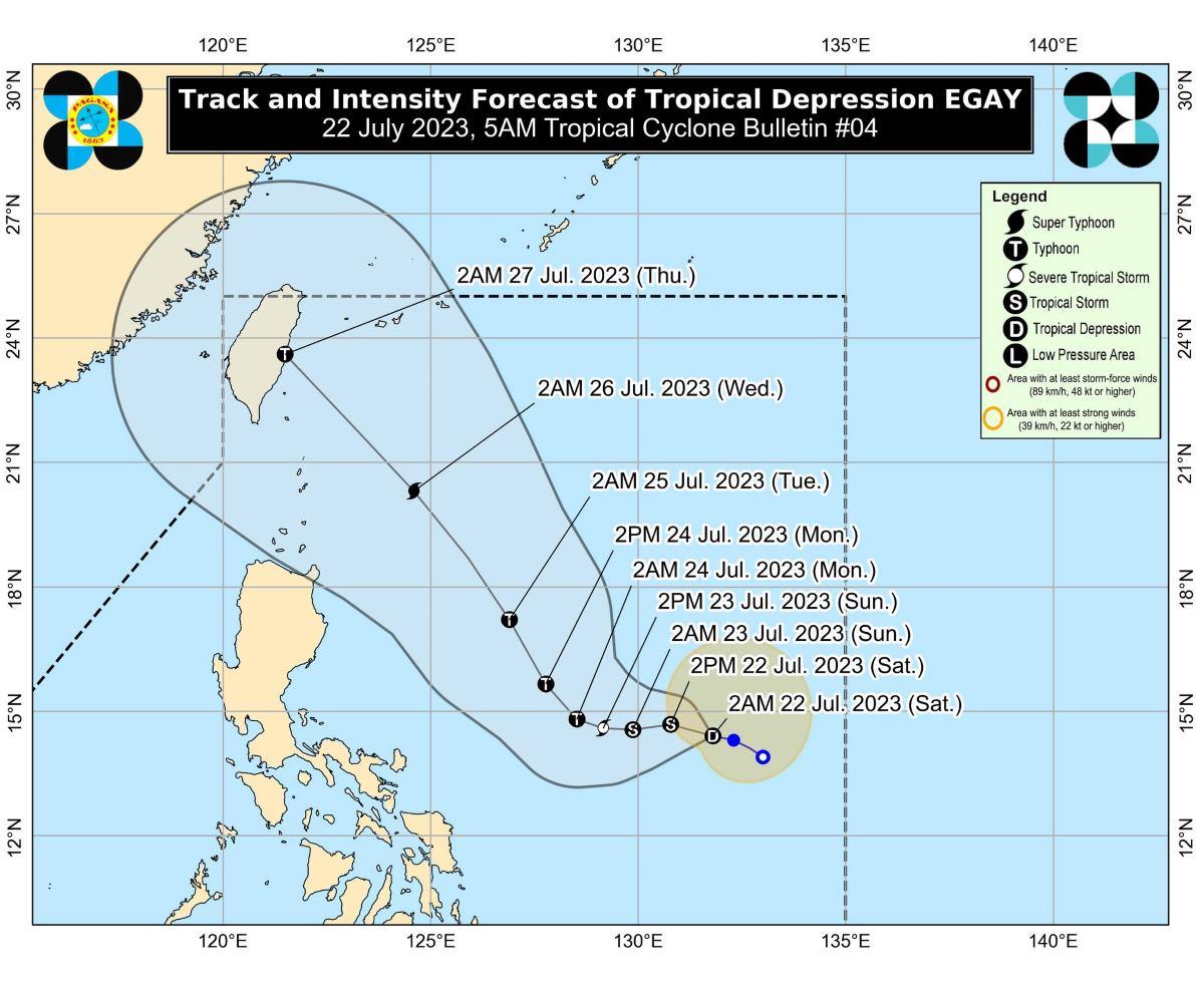
At 4 a.m., the eye of Egay was estimated to be located at 815 km east of Southeastern Luzon.
Egay has maximum sustained winds of 55 km/h near the center, gustiness of up to 70 km/h, and central pressure of 1004 hPa.
It is moving west northwestward at 10 km/h, the weather bureau said.
From Egay's center, strong winds are extending outwards up to 290 km.
No tropical cyclone wind signals (TCWS) were raised at this time.
However, PAGASA said it may raise TCWS later on Saturday or on Sunday in some areas in the Bicol Region and Eastern Visayas in anticipation of strong breeze to near-gale conditions associated with Egay.
Catanduanes may expect 50-100 mm of rainfall on Monday due to the tropical depression.
Egay however may enhance the Southwest Monsoon (Habagat) this weekend and next week.
Western Visayas may have occasional rains on Sunday.
On Monday, Western Visayas, Occidental Mindoro, and the northern portion of Palawan including Calamian Islands may likely have occasional rains.
"Forecast rainfall are generally higher in elevated or mountainous areas. Under these conditions, flooding and rain-induced landslides are possible, especially in areas that are highly or very highly susceptible to these hazard as identified in hazard maps and in localities that experienced considerable amounts of rainfall for the past several days," PAGASA said.
The monsoon may cause gusty conditions in the following areas, especially in coastal and upland/mountainous areas exposed to winds:
Saturday: The western and southern portions of Visayas, the northern portions of Northern Mindanao and Caraga, Romblon, and Masbate;
Sunday: Tomorrow: Most of Visayas and Mimaropa and the northern portions of Northern Mindanao and Caraga;
Monday: Monday: Mimaropa, most of Visayas, the northern portions of Northern Mindanao and Caraga, and portions of Zamboanga Peninsula.
Coastal waters
Moderate to rough seas up to 3 meters high may be experienced in the seaboards of eastern seaboards of Southern Luzon, Visayas, and Mindanao on Sunday.
PAGASA advised mariners of small seacraft to take precautionary measures when venturing out to sea, and if inexperienced or operating ill-equipped vessels, to avoid navigating.
Track, intensity
"EGAY is forecast to track generally west northwestward or westward today and tomorrow before turning northwestward for the remainder of the forecast period," PAGASA said.
It will remain offshore over the Philippine Sea, based on current forecast track, the weather bureau added.
However, "a landfall scenario over the northern portion of Northern Luzon is not ruled out at this time," PAGASA said.
On Saturday, Egay is expected to intensify into a tropical storm.
On Tuesday or Wednesday, Egay may reach super typhoon category while over the Philippine Sea east of Extreme Northern Luzon.
PAGASA advised the public and disaster risk reduction and management offices concerned to take the necessary measures to protect life and property.
The next bulletin will be issued by PAGASA at 11 a.m. —KG, GMA Integrated News
