TD Chedeng may reach typhoon category by Thursday —PAGASA

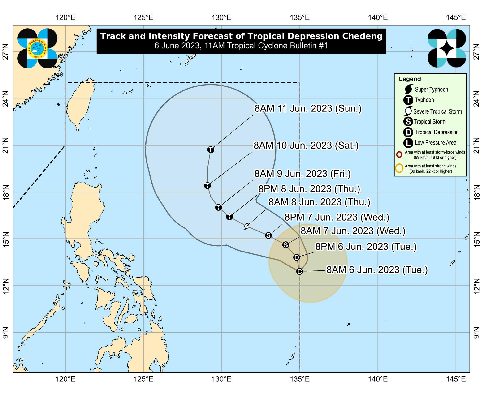
Tropical Depression Chedeng is expected to become a typhoon in the coming days and become stronger by the weekend, according to PAGASA.
“This tropical cyclone may reach typhoon category by Thursday and reach its peak intensity during the weekend while over the Philippine Sea east of Northern Luzon,” the state weather bureau said in its 11 a.m. advisory on Tuesday.
Due to this, PAGASA advised concerned public and disaster risk reduction and management offices to take all necessary measures to protect life and property.
Residents of areas prone to hazards are advised to follow evacuation and other instructions from local officials.
There are no wind signals raised at this time, according to PAGASA.
“Wala tayong nakikitang direktang epekto pagdating sa mga wind signal, mababa ang tsansa so mababa din ang tsansa ng heavy rainfall warning,” PAGASA weather specialist Veronica Torres told Super Radyo dzBB.
(We cannot see any direct effect in terms of wind signal, the chance is low so the chance of heavy rainfall warning is also low.)
PAGASA said Chedeng is expected to develop into a tropical storm by Wednesday as it gets closer to the country.
“Owing to favorable environmental conditions, Chedeng is forecast to intensity in the next 4 days and may be upgraded to tropical storm category by tomorrow,” PAGASA said in
At 11 a.m., Chedeng was located 1,170 kilometers east of Central Luzon, packing a maximum sustained winds of 45 km per hour (km/h), gustiness of up to 55 km/h, and central pressure of 1004 hPa.
Chedeng’s strong winds extend outwards up to 360 km from the center.
The tropical depression was almost stationary.
While Chedeng is unlikely to directly bring heavy rainfall over any portion of the country in the next three to five days, PAGASA said it is expected to enhance the Southwest Monsoon.
PAGASA advised the public to keep monitoring updates as the agency will issue weather advisories if there is an increasing chance of heavy rainfall within the next three days.
The tropical depression is unlikely to cause rough sea conditions over the coastal waters of the country in the next 24 hours, PAGASA said.
Chedeng is expected to remain far from the Philippine landmass, according to PAGASA.
It is seen to gradually accelerate and move generally northwestward today before turning west-northwestward on Wednesday.
Chedeng will maintain its west northwestward movement from Wednesday until Thursday before turning towards the northwest on Friday and to the north during the weekend. —Joviland Rita / VAL, GMA Integrated News


