

Betty downgraded to Severe Tropical Storm as Signal No. 1 remains over Batanes
Batanes remained under Signal No. 1 as Typhoon Betty weakened into a severe tropical storm as it moved northward, PAGASA said in its latest Tropical Cyclone bulletin.
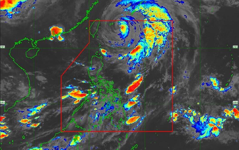
As of 4 a.m., the center of Severe Tropical Storm Betty was estimated at 505 kilometers northeast of Itbayat, Batanes packing maximum sustained winds of 110 kilometers per hour near the center, gustiness of up to 135 km/h, central pressure of 975 hPa and moving northward at the speed of 15 km/h.
Heavy Rainfall Outlook
The forecast accumulated rainfall from tonight to tomorrow evening of 50-100 mm over La Union, Benguet, Ilocos Sur, and the southern portion of Abra.
Flooding and rain-induced landslides are possible in these areas especially in areas that are highly or very highly susceptible to these hazards.
"As Betty continues to move away from country, the Southwest Monsoon will become the dominant rain-causing system in the country within the day," the weather bureau reported.
Severe Winds
PAGASA said that if there are no significant changes in the track or extent of the tropical cyclone, the wind signal over Batanes will be lifted by noon or afternoon today.
There will still be minimal to minor impacts from strong winds in Batanes.
Meanwhile, the enhanced Southwest Monsoon will bring occasional to frequent wind gusts over northern Cagayan including Babuyan Islands, Ilocos Region, Cordillera Administrative Region, Central Luzon, Metro Manila, CALABARZON, Bicol Region, MIMAROPA, Western Visayas, Northern Samar and the northern portion of Samar.
Occidental Mindoro, Antique, and northern Palawan including Cuyo, Calamian, and Kalayaan Islands will have monsoon rains due to the southwest monsoon with the possible occurrence of flash floods or landslides due to moderate to at times heavy rains.
Metro Manila and the rest of Luzon and of Visayas will have cloudy skies with scattered rain showers and thunderstorms due to the southwest monsoon and Betty with possible occurrence of flash floods or landslides due to moderate to at times heavy rains.
Mindanao, meanwhile, will have partly cloudy to cloudy skies with isolated rain showers or thunderstorms due to the southwest monsoon with possible flash floods or landslides occurring during severe thunderstorms.
Hazards affecting coastal waters
With Betty and the enhanced southwest monsoon, a marine gale warning remains in effect over the northern seaboards of Northern Luzon, the eastern seaboard of Luzon, and the western seaboard of Southern Luzon.
Track and Intensity outlook
Betty will continue to gradually accelerate northward or north northeastward until this afternoon before beginning to turn northeastward or east northeastward over the waters near the Ryukyu Islands.
The severe tropical storm will leave the Philippine Area of Responsibility (PAR) this afternoon or evening.
Outside the PAR, Betty may make landfall or pass very close to Okinawa Island tonight or tomorrow early morning.
Sunrise will be at 5:26 a.m., sunset at 6:22 p.m. -- BAP, GMA Integrated News
