

Batanes remains under Signal No. 2 as Betty moves slowly over sea east of Batanes
Batanes remained under Signal No. 2 as Typhoon Betty moved slowly over sea east of the province, according to the latest PAGASA bulletin.
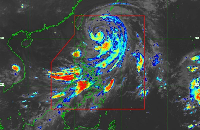
As of 4 a.m., the center of the eye of Typhoon Betty was estimated at 320 kilometers East of Itbayat, Batanes packing maximum sustained winds of 120 kilometers per hour near the center, gustiness of up to 150 km/h, and central pressure of 970 hPa, and moving slowly in the north northwest direction.
A former super typhoon with an international name of Mawar, Betty is expected to exit the Philippine Area of Responsibility (PAR) by Thursday evening or Friday morning.
Though there was hardly any rain as of Wednesday morning, Batanes experienced strong winds and waves, prompting 56 people to evacuate, according to Jonathan Andal's report on Unang Balita.
Of the total number of evacuees, 26 were staying in evacuation centers while 30 were taking shelter in other places.
While Batanes remained under Tropical Cyclone Wind Signal (TCWS) No. 2, the following areas were under TCWS No. 1:
- Cagayan
- Babuyan Islands
- the northern and eastern portions of Isabela (Santo Tomas, Santa Maria, Quezon, San Mariano, Dinapigue, Delfin Albano, San Pablo, Ilagan City, Benito Soliven, Tumauini, Cabagan, Palanan, Quirino, Divilacan, Gamu, Maconacon, Naguilian, Mallig)
- the eastern portion of Ilocos Norte (Piddig, Bangui, Vintar, Marcos, Pagudpud, Banna, Adams, Carasi, Dingras, Solsona, Dumalneg, Nueva Era)
- Apayao
- the northern portion of Kalinga (City of Tabuk, Balbalan, Pinukpuk, Rizal)
- the northeastern portion of Abra (Tineg, Lacub, Malibcong)
Heavy Rainfall Outlook
Batanes and Cagayan will have rains with gusty winds due to Betty with the possibility of flooding or landslides due to moderate to heavy rains and minimal to minor threat to lives and properties due to strong winds.
Metro Manila, the rest of Luzon, and Western Visayas will have cloudy skies with scattered rain showers and thunderstorms due to the southwest monsoon and Betty with the possibility that flash floods or landslides may occur due to moderate to at times heavy rains.
The rest of the country will have partly cloudy to cloudy skies with isolated rain showers or thunderstorms due to the southwest monsoon with possible flash floods or landslides occurring during severe thunderstorms.
The forecast accumulated rainfall from today to tomorrow afternoon, 50-100 mm over Ilocos Norte, Ilocos Sur, La Union, Abra and Benguet.
The weather bureau said that flooding and rain-induced landslides are possible, especially in areas that are highly or very highly susceptible to these hazard as identified in hazard maps and in localities that experienced considerable amounts of rainfall for the past several days.
Severe Winds
There may be minor to moderate impacts caused by gale-force winds remain possible within the areas under TCWS No. 2 and that minimal to minor impacts from strong winds are also possible within any of the areas where TCWS No.1 is currently in effect.
"The enhanced Southwest Monsoon will bring occasional to frequent wind gusts over Bicol Region, Western Visayas, Aurora, Quezon, the northern portion of mainland Palawan including Calamian and Cuyo Islands, Mindoro Provinces, Romblon, and the remaining areas of Ilocos Region and Cordillera Administrative Region that are not under any Wind Signal."
Hazards affecting coastal waters
Under the influence of Typhoon Betty and the enhanced Southwest Monsoon, a marine gale warning remains in effect over the seaboards of Northern Luzon, eastern seaboards of Central Luzon, Southern Luzon, and Visayas.
Track and Intensity Outlook
Betty is forecast to slowly accelerate today through Thursday morning while moving generally northward over the waters east of Batanes, although some wobbling in its movement is possible.
The typhoon will then turn more northeastward by Thursday afternoon or evening and exit the Philippine Area of Responsibility (PAR) in the evening or on Friday early morning.
Outside the PAR, PAGASA reported, the tropical cyclone will pass very close or make landfall in the vicinity of central Ryukyu Islands by mid-Friday.
Sunrise will be at 5:26 a.m., sunset by 6:22 p.m. -- BAP/KBK, GMA Integrated News
