Signal No. 2 up in Batanes, some parts of Cagayan as Betty slows down

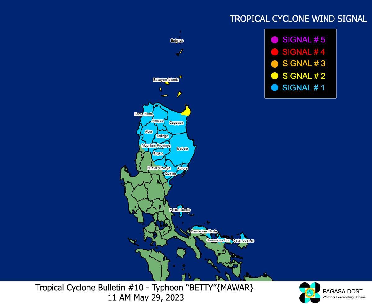
Tropical Cyclone Wind Signal (TCWS) No. 2 is hoisted over two areas as Typhoon Betty slows down towards east of Batanes, state weather bureau PAGASA said Monday.
In its 11 a.m. advisory, PAGASA said the following areas are under TCWS No. 2:
- Batanes
- the northeastern portion of Cagayan (Santa Ana, Gonzaga) including Babuyan Islands
Meanwhile, the TCWS No. 1 is raised over the following areas:
- The rest of mainland Cagayan
- Isabela
- Apayao
- Ilocos Norte
- Abra
- Kalinga
- Mountain Province
- Ifugao
- the northern and central portions of Aurora (Dilasag, Casiguran, Dinalungan, Dipaculao, Baler)
- Quirino
- the northeastern portion of Nueva Vizcaya (Kasibu, Quezon, Solano, Bagabag, Diadi, Villaverde, Bayombong, Ambaguio)
- the northern portion of Catanduanes (Caramoran, Viga, Gigmoto, Panganiban, Bagamanoc, Pandan)
- the northeastern portion of Camarines Sur (Caramoan, Garchitorena, Lagonoy, Tinambac, Siruma)
- Pollilo Islands
- the northern portion of Camarines Norte (Vinzons, Paracale, Jose Panganiban, Capalonga, Talisay, Daet, Mercedes, Basud)
- the northern and central portions of Ilocos Sur (Gregorio del Pilar, Magsingal, San Esteban, Banayoyo, Cervantes, Burgos, Santiago, San Vicente, Santa Catalina, Lidlidda, Nagbukel, Sinait, Sigay, San Ildefonso, Galimuyod, Quirino, City of Vigan, San Emilio, Cabugao, Caoayan, San Juan, Santa, Bantay, Santo Domingo, Santa Maria, Narvacan, Salcedo, City of Candon)
PAGASA officer-in-charge Esperanza Cayanan, however, said that Betty will not directly hit areas in Northern Luzon.
"Ang kagandahan nito ay nasa karagatan itong bagyo na ito at hindi nito masasapul o matataman itong mga isla ng Batanes, or even the Cagayan area. Ito ay nakikita natin na medyo babagal habang dumadaan sa karagatan papuntang northwest," she said in a public briefing.
(The good thing about this is that this typhoon is in the ocean and will not hit the islands of Batanes or Cagayan. We can see that the typhoon will slow down a bit while passing the ocean to the northwest.)
At 10 a.m., Betty was located at 470 km east of Aparri, Cagayan or 475 kilometers east of Calayan, Cagayan packing maximum sustained winds of 155 kilometers per hour (kp/h), gustiness of up to 190 km/h, and central pressure of 950 hPa.
Betty decelerated to 15 km/h as it moved northwestward.
The typhoon will move generally northwestward slowly on Monday and may become slow-moving or almost stationary from Tuesday to Wednesday while over the waters east of Batanes.
Then, the typhoon will turn north-northeastward on late Wednesday or Thursday and gradually accelerate towards the waters east of Taiwan and the southern portion of Ryukyu Islands.
Cayanan explained that one of the reasons Betty is weakening is because of the "dry air."
"Ang dahilan ng paghina nito ay dahil meron tayong tinatawag na dry air o walang masyadong moisture na pumapasok sa bagyo na ito kaya tuluyang humihina o nagwe-weaken," she said.
(The typhoon is weakening because we have dry air or there is not much moisture entering this storm.)
The National Disaster Risk Reduction and Management Council (NDRRMC) has already activated its emergency preparedness and response (EPR) protocols in preparation for Betty's onslaught.
Preemptive evacuations were also conducted by local government units as a precaution against the typhoon. The Department of Social Welfare and Development (DSWD), which has started distributing food packs to the affected families.
Classes in some areas were also canceled on Monday, as were some flights.
Meanwhile, a number of tourists were stranded in Batanes due to strong waves and winds in the province brought by Betty, according to the Batanes Emergency Operation Center.
Betty is expected to exit the Philippine Area of Responsibility (PAR) on Friday, according to PAGASA. —with Giselle Ombay/ VAL, GMA Integrated News


