Signal No. 1 up over 20 Luzon areas as Paeng moves toward PAR exit

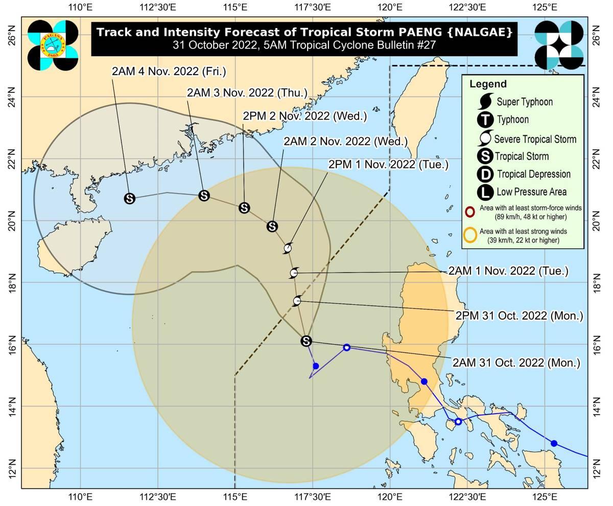
Tropical Cyclone Wind Signal No. 1 remains hoisted over 20 areas on Monday morning as Tropical Storm Paeng (international name: Nalgae) moves toward the northwestern limit of the Philippine Area of Responsibility (PAR), PAGASA said in its 5 a.m. bulletin.
TCWS No. 1 is in effect over:
- Ilocos Norte;
- Ilocos Sur;
- La Union;
- Pangasinan;
- Apayao;
- Kalinga;
- Abra;
- Mountain Province;
- Ifugao;
- Benguet;
- Nueva Vizcaya;
- the western portion of Cagayan (Santa Praxedes, Claveria, Sanchez-Mira, Pamplona, Abulug, Ballesteros, Allacapan, Lasam, Santo Niño, Piat, Tuao, Rizal);
- the western portion of Isabela (Cordon, City of Santiago, San Mateo, Ramon, Alicia, San Isidro, Quezon, Mallig, Roxas, San Manuel, Aurora, Cabatuan);
- the northwestern portion of Quirino (Cabarroguis, Diffun, Saguday);
- the northern, western, and southern portions of Nueva Ecija (Cuyapo, City of Gapan, Talavera, San Leonardo, Santo Domingo, Rizal, San Isidro, Zaragoza, Llanera, Guimba, Aliaga, Science City of Muñoz, General Mamerto Natividad, Cabanatuan City, Carranglan, Quezon, San Antonio, San Jose City, Santa Rosa, Lupao, Nampicuan, Talugtug, Peñaranda, Jaen, Licab, Cabiao, Pantabangan);
- Pampanga;
- Bataan;
- Tarlac;
- Zambales; and
- the western portion of Bulacan (Hagonoy, Paombong, City of Malolos, Guiguinto, Calumpit, Pulilan, Plaridel, Baliuag, Bustos, San Miguel, San Ildefonso, San Rafael).
These areas will have strong winds (strong breeze to near gale strength) in 36 hours.
TCWS in other areas were lifted.
At 4 a.m. on Monday, the center of Paeng was estimated to be located at 320 km west northwest of Iba, Zambales or 340 km west of Dagupan City, Pangasinan.
It has maximum sustained winds of 85 km/h near the center, gustiness of up to 105 km/h, and central pressure of 990 hPa.
From Paeng's center, strong to gale-force winds are extending outwards up to 650 km.
Paeng is moving west northwestward at 10 km/h.
It is expected to exit PAR on Monday afternoon or evening.
Heavy rainfall
Batanes, Zambales, Bataan, Occidental Mindoro, and Palawan including Calamian and Cuyo Islands may expect moderate to heavy rains on Monday morning.
The Ilocos Region, Cordillera Administrative Region, Metro Manila, Calabarzon, Western Visayas, Babuyan Islands, the rest of Central Luzon and Mimaropa meanwhile may possibly have light to moderate with at times heavy rains.
Flooding and rain-induced landslides are likely to slowly subside except in areas with significant antecedent rainfall or still experiencing persistent heavy rainfall.
Coastal waters
A marine gale warning remains in effect over most seaboards of Luzon due to the surge of the Northeast Monsoon (Amihan) and Paeng.
The western seaboard of Visayas may have moderate to rough seas due to Paeng, with waves possibly reaching up to 3 meters.
"These conditions may be risky for those using small seacrafts. Mariners are advised to take precautionary measures when venturing out to sea and, if possible, avoid navigating in these conditions," PAGASA said.
Intensity outlook
Paeng may likely re-intensify into a severe tropical storm within 12 to 24 hours.
However, it may weaken by late Wednesday or on Thursday.
PAGASA advised the public and disaster risk reduction and management offices concerned to take all necessary measures to protect life and property.
Queenie
Meanwhile, a tropical depression near Palau entered the PAR at 5 a.m. on Monday.
It was named Queenie by PAGASA.
The weather bureau will issue the next bulletins about Paeng and Queenie at 11 a.m.
98 dead
The number of fatalities due to Paeng has climbed to 98, the National Disaster Risk Reduction and Management Council (NDRRMC) said on Monday.
NDRRMC Assistant Secretary Bernardo Rafaelito Alejandro IV, in an interview on Unang Balita on Monday, said there were 69 injured and 63 missing. —KG, GMA News


