Signal No. 2 up over 9 areas as Paeng traverses West Philippine Sea

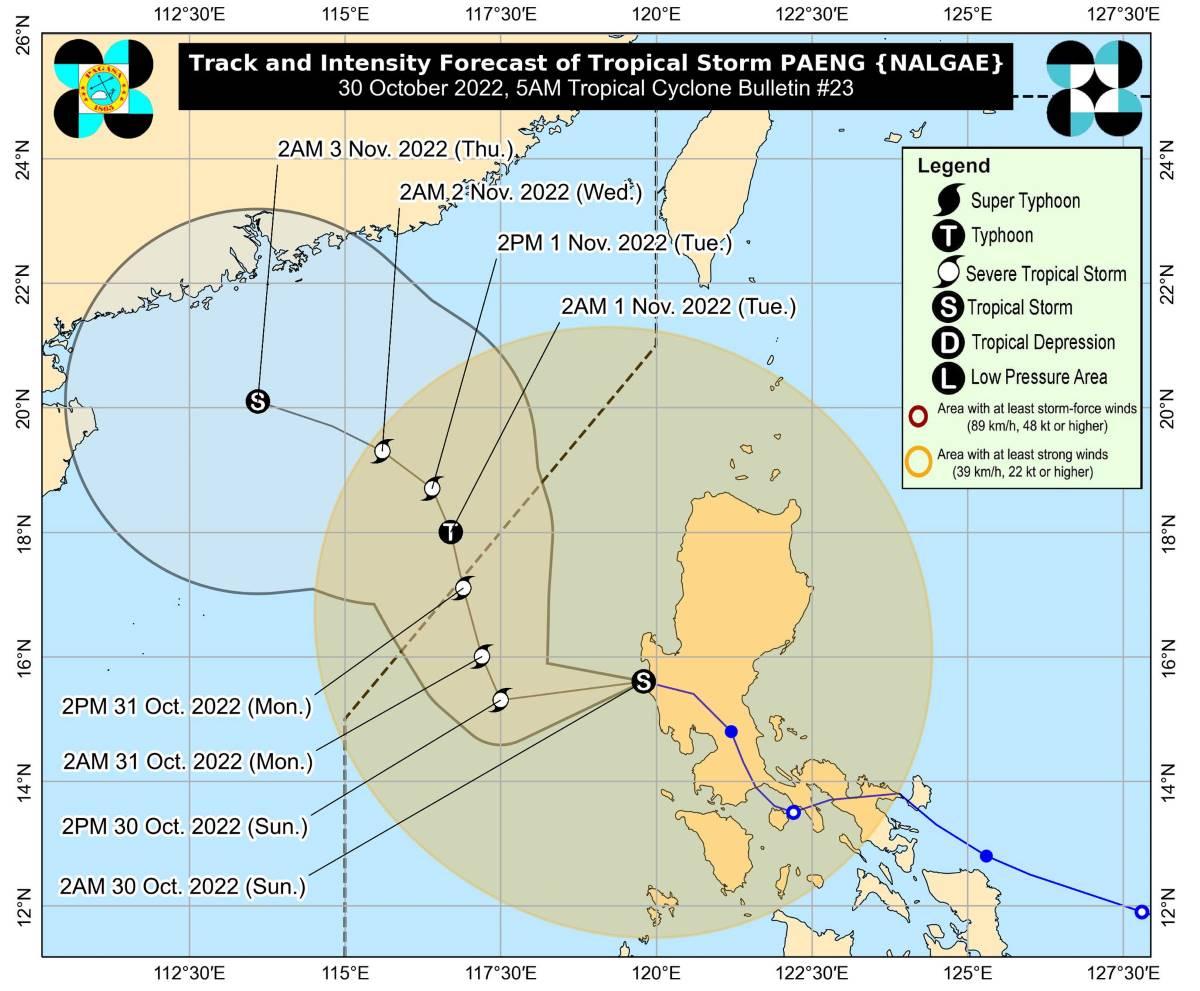
Tropical Cyclone Wind Signal (TCWS) No. 2 was hoisted over nine areas on Sunday morning as Tropical Storm Paeng (international name: Nalgae) traverses the West Philippine Sea, PAGASA said in its bulletin.
TCWS No. 2 is in effect over the following areas:
- Pangasinan;
- La Union;
- the southern portion of Ilocos Sur (City of Candon, Banayoyo, Galimuyod, Sigay, Suyo, Santa Lucia, Santa Cruz, Alilem, Tagudin, Sugpon, Cervantes, Quirino, Gregorio del Pilar, Salcedo, Lidlidda, San Emilio, Santiago, Burgos, Santa Maria, San Esteban);
- Benguet;
- Tarlac;
- Zambales;
- the western portion of Bataan (Morong, Bagac, Dinalupihan, Hermosa);
- the western portion of Pampanga (Floridablanca, Mabalacat City, Magalang, Angeles City, Porac); and
- the northwestern portion of Nueva Ecija (Guimba, Cuyapo, Talugtug, Nampicuan).
These areas may experience gale-force winds greater than 62 km/h and up to 88 km/h in at least 24 hours which may pose minor to moderate threat to life and property.
TCWS No. 1 meanwhile was raised over the following areas:
- Cagayan including Babuyan Islands;
- Isabela;
- Quirino;
- Nueva Vizcaya;
- Apayao;
- Kalinga;
- Ifugao;
- Mountain Province;
- Abra;
- Ilocos Norte;
- the rest of Ilocos Sur;
- Aurora;
- the rest of Nueva Ecija;
- the rest of Pampanga;
- Bulacan;
- the rest of Bataan;
- Metro Manila;
- Laguna;
- Rizal;
- Batangas;
- Cavite;
- Quezon including Pollilo Islands;
- Marinduque;
- the northwestern portion of Romblon (Concepcion, Banton, Corcuera); Occidental Mindoro including Lubang Islands;
- Oriental Mindoro;
- Calamian Islands;
- Camarines Norte; and
- the northwestern portion of Camarines Sur (Lupi, Ragay, Del Gallego, Sipocot).
Areas under TCWS No. 1 may expect strong winds of 39-61 km/h in at least 36 hours or intermittent rains within 36 hours.
At 4 a.m., the center of Paeng was estimated to be located at 85 km west northwest of Iba, Zambales, packing maximum sustained winds of 85 km/h near the center, gustiness of up to 105 km/h, and central pressure of 990 hPa.
Paeng is moving west northwestward at 30 km/h.
From its center, strong to gale-force winds are extending outwards up to 650 km.
Heavy rainfall
Zambales, Bataan, Aurora, Pangasinan, Batanes, and the northern portion of Cagayan including Babuyan Islands may have moderate to heavy rains on Sunday morning.
Metro Manila, Cordillera Administrative Region, Calabarzon, Mimaropa, Camarines Provinces, Western Visayas, and the rest of Cagayan Valley and Central Luzon meanwhile may possibly have light to moderate with at times heavy rains.
"Except in areas with significant antecedent rainfall or those still experiencing persistent heavy rainfall, flooding and rain-induced landslides are likely to slowly subside," PAGASA said.
The rest of Mindanao meanwhile will have partly cloudy to cloudy skies with isolated rain showers or thunderstorms due to localized thunderstorms. During severe thunderstorms, flash floods or landslides may result.
Coastal waters
A marine gale warning is still in effect over the seaboards of Luzon and the western and eastern seaboards of Visayas due to the surge of the Northeast Monsoon and Paeng.
Coastal waters will be rough in the seaboards in the western section of Luzon, with waves possibly reaching up to 6 meters.
The rest of the seaboards in Luzon and Visayas will have moderate to rough coastal waters, with wave heights possibly reaching up to 5 meters.
In Mindanao, coastal waters will also be moderate to rough, with waves possibly reaching up to 4 meters.
Track, intensity outlook
Paeng exited the Luzon landmass at 2 a.m. on Sunday.
It also was downgraded into a tropical storm from a severe tropical storm category.
Paeng is expected to continue generally westward until Sunday afternoon then turn north northwestward on Sunday night until Tuesday. From then on it may turn northwestward on Wednesday, moving closer to southern China.
Paeng is expected to exit the Philippine Area of Responsibility (PAR) on Monday morning or afternoon.
It may re-intensify into a severe tropical storm within 24 hours while over the West Philippine Sea, then further intensify into a typhoon by late Monday evening or Tuesday morning.
PAGASA advised the public and disaster risk reduction and management offices concerned to take all necessary measures to protect life and property.
The weather bureau will issue the next advisory at 11 a.m.
Tropical depression outside PAR
Meanwhile, PAGASA is monitoring a tropical depression located outside PAR.
As of 3 a.m. on Sunday, the tropical depression was estimated to be located at 1,385 km east of northeastern Mindanao.
It has maximum sustained winds of 45 km/h near the center and gustiness of up to 55 km/h.
The tropical depression is moving west northwestward at 10 km/h.
Sunrise was at 5:51 a.m. while sunset will be at 5:29 p.m. —KG, GMA News


